

Retired Judge James T.O. Keefe passed away at age 69 in Palo Alto 1979. Certainly he ruled over fascinatiing cases, but his father, also a judge ,was, I believe involved in Pescadero cases such as the famous “Pebble Beach War.”
Here’s the obit:
“Born in Menlo Park, he was the son of the late James T. O’Keefe, Sr, who was dean of the San Mateo County bar when he died at the age of 93. His mother, Mary Ellen O’Keefe, was a member of the pioneer Gilcrest family of Half Moon Bay and was born there when it was known as Spanish Town.
“After serving for 26 years as Menlo Park attorney, Judge O’Keefe was elected to the bench in 1960. As a jurist, he was famous for his wit, his human touch and his vast amount of patience. For this latter quality he became known as ‘the Marathon Judge.’
“During his term on the bench he established a few records for long distance cases. One case for damages required 55 days before a jury, while a land dispute ran 70 days. He sat through 62 days of seemingly endless argument over who was to pay for shipments of tropical flowers from Hawaii to the mainland.
“And some sort of record was set when Judge O’Keefe presided over a 25-day divorce trial. At stake was $6 million in community property. Long trials did not bother Judge O’Keefe, obviously, because, as he said:
“In the interest of justice no unfair impediment solely in the interest of time should be interposed, because to do so may well distract and deny justice……”
All images from Authors John & Kristina Schmale, to see their latest book, please click here
Hi June,
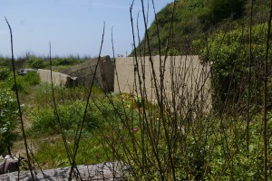
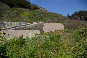
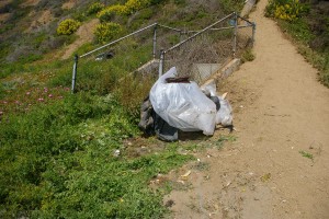
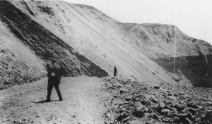
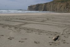
These pictures of the Waddell beach bypass road from John Schmale are spectacular. I can hardly wait to see what else he has. I sent he and Angelo, each other’s phone numbers. They both live in Bennett Valley in Sonoma. I also talked to Ed Weeks, (82) who remembers visiting the Pescadero OSR bore tunnel. He was telling me how the engineers for the construction of the Pescadero coast bridge and highway lived at his house(he had to sleep on the sofa) for three years during the construction. Meg and I are going to visit his home(he says you published a picture of it) as soon as possible. enjoy. John
———————–
[Message below is from John & Kristina Schmale to John Vonderlin]
Hi John,
Thanks for the response to my email and the encouraging words concerning our book.
I would love to meet Angelo. My wife and I live in Bennett Valley as well. I could probably throw a rock and hit his house. Bennett Valley area is only a few square miles. I am sorry that I did not get to talk with Angelo at our signing. The one in petaluma was somewhat disrupted by a pair of rabid railfans who would wanted more of our attention than we had time for. I am being kind by using mild language. The woman who runs the bookstore says they show up for any railroad related event.
I and many other people would love to see the OSR route material and photo you have
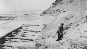
of the Waddell bluff area. I’m sure Angelo Misthos, who has been exchanging emails (some of which are on June’s PM website) with me, and is the source of most of my interest in the OSR, would love to talk to you. He lives in Bennett Valley. He made it to your Sonoma booksigning, but there was a line of people waiting to talk to you, so he just bought a book and went home. I’ll send him an email about you contacting me and will make sure I can forward his phone number if you’d like to talk to him.I’m excited about solving the mystery of where the OSR actually planned to go, and whether our “educated” guesses were right. Thanks for contacting me, and congratulations on your book. Enjoy. John Vonderlin
P.S. I’ve scooped a large number of articles from the Newspaper Archives about the fishing and fish of the early Coastside that I need to organize, but would be glad to share. —————————————[Message below from John Schmale to John Vonderlin]
Hi John,
I have read your posts on the San Mateo coast history on June Morrall’s
site and have related to what you have to say. You have been following the
proposed route of the Ocean Shore Railway along the coast between Tunitas and
Swanton. Please contact me as I did the same back in the 1970’s and would be
happy to compare notes. I have a completed manuscript covering the Ocean Shore
Railroad and the events leading up to its incorporation. I would like to hear
your views on the Ocean Shore Ry. and coastside history including fishing etc..
The ocean Shore Ry engineers built a rock filled cribbing fill along the bottom
of the Waddell bluffs in 1905 to test the action of the waves. Part of their
franchise required them to build the county road alongside of the Ocean Shore
right of way. I have a photo of it taken in 1909. Tracks were never built on it,
but it was mostly still intact.
Regards,
John Schmale
Say Angelo Mithos: The last picture is the one with the man with rolled up papers under his arm and the boy with the pail in the background–pail visible by his right leg. That is the scene looking south toward the bluff on the other side of which is the sluice cut as stated in the Bondholders Report, where these pictures appear. That picture must be the last gasp of the OS as least as far as grading goes as they never went the short distance beyond to meet the sluice cut. Re your attachment depicting the electric car equipped with pantographs: as far as I know the OS never had such cars. I have a picture of such a car (drawing) at the Granada Station. I’ll sent it as an attachment when my daughter comes up. The OS did have three electric locomotives used to haul trains between the 12th and Mission Station in San Francisco to the shops at Barnevald Ave. In S.F., and vice versa, in compliance withe the franchise prohibiting steam power in that portion of the
line. I know of one occasion when the OS violated that rule, taking a steam powered passenger train all the way to the station, engendering a huge protest from residents along Potrero St. who wanted the City to revoke the OS’s franchise–didn’t happen. Believe an S.F. Call article had this too. When the OS finally gave up it sold one of the electric engines tto the Petaluma & Santa Rosa Railway and another to the California Wine Association. Don’t know about the third. The electric motor trucks (wheel and axle assemblies) it planned to use on its electric coaches (if and when!) were sold at that time to the Sacramento Northern or one of its predecessors. The OS acquired two gas-powered rail cars in its last years of operation as an economy move; I don’t know the dispositon of these. John, I don’t remember if I referred you to this site befrore, but if not Google: calisphere university of california.edu. In the search block at right type in ocean shore railway. This will give you a set of photographs of damage to the double-tracked OS grading from the ’06 earthquake, which effectively turned the OS into a single-track steam line. The rock in the far background is Mussel Rock. This is the area I hiked with my uncle and older brother in roughly 1927-28, only about a half dozen years after the rails were torn up, and started my interest in the OS. I’ve noted incorrect info. on the Web that the the earthquake threw track and equipment, even an engine into the surf at Devil’s Slide. Pure fiction. The scenes in the Calishphere photos were about as far as the OS got when the earthquake came. Angelo
From the files of Richard Schellen
“In November 1871 already, Orrin Brown purchased a large hunk of land in San Mateo from George S. Mann. The price paid for the land was $10,000, and the property itself was Block 4 as shown on the 1863 map of San Mateo. In July 1872 Orrin Brown made quite elaborate plans with Loren Coburn, the eccentric millionaire, to build a boom near the mouth of the Pescadero Creek to impound any logs brought down the creek from the lumber area above Pescadero, to build a sawmill and possibly also a wharf at the spot, all in order to cut costs.
“Presumably all this would occur on Brown’s property, the proposed boom and sawmill site to be where Cabrillo Highway crosses the marshland at Pescadero Creek. Apparently these plans were not carried out, for the Coburn plan to get the lumber to San Francisco. eventually took place at Pigeon Point instead.
“In May 1873 Brown leased 700 acres to J.C. Williamson of Pescadero; at the same time he also leased 200 acres to N.M. Brown, a local member of the Patrons of Husbandry. In October of that same year Brown bought and consolidated two meat markets in San Mateo; six months later he brought in James Wagor, formerly a schoolteacher in Pescadero, later a butcher near the Peer’s Sawmill, who became “the presiding genius of the cleaver” at the San Mateo Meat Market.
“Orrin Brown became involved in San Mateo in the establishment of the town’s first cemetery on the east side of the tracks, the so-called Evergreen Cemetery, which was used only for a few years until the establishment of St. John’s Cemetery, when the bodies were removed to the new burial grounds.
“In June 1877 Brown sold his meat market to W.Z. Price, moving back to Pescadero and farming his land, or what was not leased out to Hugh Carlton Walche of Pescadero for experimental growing of flax. Brown had raised about 200 acres of flax, out of which he obtained some 2400 centals of seed, which he promptly sold at a fair profit to a San Francisco firm; Walche leased 900 acres to try to repeat this performance.
“The date of death of Orrin Brown is yet to be determined, but it probably took place soon after his return to Pescadero, and certainly before January 1881. It was then that Esther C. Brown, the widow leased 1000 acres to James McCormick of Pescadero for farming purposes for a period of two years, starting with March 1, 1880.”
From the Richard Schellen Collection
A force of men are at work at Point New Year on the Ano Nuevo fog signal. The action of the waves last winter undermined a portion of the ground where the signal house stnads, which necessitated the building of a breakwater. Some 300 barrels of cement will be used in constructing this wall.
From the Richard Schellen Collection
Eli D. Moore, California pioneer and the oldest member of the Native Sons’ order in San Mateo County, passed away at home in Pescadero Monday. His last illness was the first serious one he had ever experienced. He was bedridden for two weeks in his vine-covered cottage that he had made his home in the picturesque Coastside for so man years.
Moore was born under the Mexican flag at Santa Cruz, December 12, 1847. on the land purchased by his grandfather, Eli Moore, from Jose Balcoff. This is believed to have been the first instance of transfer of land in that section to an American. Moore was the son of Mr. and Mrs. Alexander Moore, immigrants to California from Missouri in 1847. The family lived first at Mission San Jose and then at Santa Cruz, moving to Pescadero in 1850, where they later secured large land holdings.
In 1876 Moore married Miss Ellen McCormick, member of another well-known pioneer family of the Coastside. Of several children born to the couple, only one is living, Edmund Moore. There are two surviving brothers, William A. and J. L. Moore, both of Pescadero, and a sister, Mrs. Charles Steele. Dave Moore, a third brother, passed away in this city last year. ….Internment was in the family plot in Pescadero.
————
Story from John Vonderlin
Email John [email protected])

How :^ well’he;’ carries “out- his ;Dromls«» !
of the great Carillo family ;_ Jose An
tonio Torba, founder of the family, of
that name and grantee of .the Rancho
-Santiago Santa Ana, and others. . .
To Sergeant Ortega is\ given; the
credit of having .discovered the Golden
gate and Carquiriez strait. This state
ment, it Is expected, will arouse dis
pute, but the author is .prepared to de
fend it. Ortega certainly received high,
honors later. He became lieutenant
and brevet captain, comandante .of:
the Presidio /of Monterey, founder- *of
the Presidio of Santa Barbara and of
the missions “of San Juan Caplstrano:
and San Buenaventura.’ – ,
The march was a difficult one, by
reason of its being through an un
known country, with danger from
lurking hostile Indians. From twb ;
to four Spanish leagues (5 to 10 stat-.
ute miles) , were made a day. The ;
road followed was V practically ; that :
known afterward as El Camino ‘real..’
On August. 18 the site of Santa Bar-;
bara was reached/ Thus far the \u0084ex- r
pedition had been received . hospitably;
by the Indians, .who , gave, them re
freshment and every I facility of their;
numerous rancherlas. Guadalupe lake,
in the northwest corner or Santa Bar
bara county, was ‘ reached on Septem
ber 10, and herea Test’was taken, as
many of the soldiers were suffering
from sore feet and some were ill. >,
Genuine troubles now began to come
thick and fast. Confronted by the Sierra
de Santa Lucia, they had to labor hard
to pass through the rugged mountains.
As they ascended the cold increased and
‘all suffered exceedingly. In’spite of this
and of the appearanoe. of scurvy,; they
pressed bravely on, a.na*on September
26 emerged f rom the f,mountalns “. “an^ |
camped atr the Salinas: river, rwhich
\u25a0 they, afterward followed ‘down* to ‘the
-sea.\: \u25a0′ ;’ .- -\:– “”: } : ‘ -\u25a0″ :’; : ~* <\u25a0′>’ i ; ;”,. \u25a0:/\u25a0:” \u25a0\u25a0-.
, Upon, reaching the mouth of the Sali
nas river, on,” September ‘; 30,- they be
lieved .that they were V close to Monte
rey, which they had for? their goal.; E
remains for the reader to .discover.
had excursions” and\ park, concerts; – to :
upset ‘a; system in. no time. -But the
xploring ; parties made reconnajsances
both: north and south In search of the
great port’v of Monterey, but . they j were
baffled. Much perplexed,’ Portola called
a council/ of \u25a0 his officers : on i October 4,
and laid the situation before them. Slx\
teen-men were, too sick to do duty, and
the labor of the rest.was increased ac
cordingly.’ The season was getting late
and further passage through the Sierra
would be obstructed by the snow. Opin
ions differed, and, after hearing all,
Portola resolutely made- nls decision,
i which was to s go f orward, # putting his
trust in God. “If Monterey were found, .
all well and good; – if : not, they should
find another place for settlement. … ah
agreed and signed a document to this,
effect. . On October 7 the march was resumed,
Ortega and his scouts in advance, .to
lay out a path. for therest of the col
umn to follow.. Sixteen of. the men had
now lost tbe’use of .their limbs. .Bach
night the ailing ones were rubbed with
oil, and In j the ‘ day »were /conveyed In
hammocks .stretched between two
mules, in , tandem. The Pajaro river
was crossed on the Bth, and on the 17th
they reached the ‘site of the present
Santa Cruz.
; .On . the 21st , and 22d, having good
water and- fuel, the command rested ay
the {‘entrance of the canyon of Waddell
creek, and here; both\ Portola and , Ri
vera, worn out by their hard work r pri
vations and-;anxiety, ‘ themselves -were
I added to the sick list. -Food .ran: low,
and’ reduced.’ rations were.s erved out.
The daily allowance was five; tortillas
•of bran and flour for each’ man, < ,- y. .
\u25a0 Relief was, found jon. the\23d- at an
Indian; r’anch’eria,” near- Pigeon ; point, \u25a0
and then they again’ pressed on toward
the’north.y; Diarrhea broke out, and all
became much alarmed, until it was dis
covered, that the ! new ailment relieved
the scurvy.^ C-f }’-” : .%’- i -.* -v’>- : \u25a0’• –
TOn’October 27 some abandoned Indian
.huts \rere ‘found, but they-were soon
given up, on account of a ; pesf of fleas
within. ; ” .; r . – ,
els” . ; and from Baron Munchau sen, and
“By noon of the next day,” according
to Mr. Eldredge’s “narrative,” “Jthe pio-.
neers had prepared a passage over the
bold promontory •’ of Point San Pedro,
and at 10 o’clock in the morning the.
company set out on the trail of the ex
pioradoros and made their painful way
to the summit. Here a wondrous sight •
met their eyes and quickened their
flagging spirits. Before ‘ them, bright
and beautiful, was spread a great ense
nada, its waters dancing in the sun
light. Far to the northwest a point
reached out Into, the “sea, rising: ab
ruptly before them, high above the
ocean. \ Further to the left.’west-north
west, were seen six or seven white Far
allqnes, ‘and finally, along the ; shore
northward, they discerned the white
cliffs and what ‘appeared to be the
! mouth of the Inlet,” ‘
Thus \u25a0’\u25a0 was the bay of San Francisco
revealed to clvllzed-man. By infer
ence it was Ortega, leader of the
scouts, who first beheld it.
Details of’the further exploration of
the great bay are given. : It took Por
tola some time to convince himself
arid his followers, that it was not Mon
terey,” but another place altogether that
they had found. Ortega, with his pio
neers, was sent on a trip of discovery
around the bay. He got as far north
as Carqulnez strait, where he turned
back,- reporting that to go around. the
estero would involve too long a jour
ney.’
‘ Hunger and the approach of winter
forced the explorer to retrace his foot
steps,, and on November 11 the little
column started bacK to renew the
search” for Monterey, c Their hardships
were . redoubled: Food was nearly all
gone. ‘They had to kill their mulea for
meat and even to eat acorns. Finding
themselves in such straits they deter
mined ;to return to San Diego, which
they did, and reached that place after
:
24. 1770.
‘The fact is that Portola really did
find the port of Monterey on his return
trip from San Francisco bay, but he
did not recognize it. He erected two
crosses — one’ upon Monterey bay, tho
identity of the place being revealed to
him in San Diego bay by Captain Vila
of the ship San Carlos.
Portola thereupon decided to. make
another expedition to Monterey, which
he did, this time with a better outfit.
He sent the ship San Antonio by sea
with Juniparo Serra. Costanso, Prat
and a large cargo of stores, he himself
-proceeding by land with Fages. 12 Ca
talan volunteers, 7 soldiers, Crespi. 2
muleteers and 5 natives. He followed
the same route ho had taken on his
retreat from Monterey and arrived on
May 24 near the cross he had planted
on December 10 preceding. The San
Antonio arrived a week later, and on
June 3, 1770. Portola and his followers,
\u25a0with appropriate ceremonies, took for
mal possession -of the country, estab
lished the Presidio of Monterey and
the mission of San Carlos de Borromeo
de Monterey, the second mission in
California. ,• -”
On July 0 Portola turned the new
statlen and the district over to Lieu
tenant Fages and sailed for San Bias.
He never returned to California.
.The translation of the log of the San
Carlos, commanded by Don Juan Ma
nuel de Ayala la a moat interesting,
. document, as 13 the report of Ayala to
Don Antonio Maria Bucareli, viceroy
of New Spain, on his examination of
the port of San Francisco in 1775. This
report is accompanied by a singularly
accurate chart of San Francisco bay.
the original of which Is now Jn tha
India office. Seville. Spain.-
The little book gives succinct!* and
in most attractive form tha explora
tions of Portola, which San Franciscans
are now about to celebrate with th* co
operation of representatives of all civ
ilized nations.
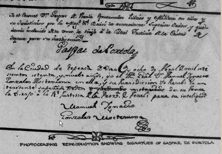
Below: Indo on Zoeth S. Eldredge’s book: The March of Portola and the Discovery of the Bay of San Francisco
From John Vonderlin
Email John ([email protected])
|
Hi June,
The book by Zoeth S. Eldredge, “The March of Portola and the Discovery of the Bay of San Francisco,” can be read for free at Archive.org. If you use “Portola” in the Search box you will find Mr. Eldredge’s book, and two other books about the 1769 Portola Expedition. One is Miguel Costanso’s diary and the other Vicente Vila’s.
Here’s the excerpt from when they were on the Coastside.
On the 20th they were at Punta de Ano Nuevo,
and camped at the entrance of the canon of Waddell creek. They recognized Point Ano Nuevo from the description given by Cabrera Bueno, and Crespi estimated that it was one league distant from the camp. With good water and fuel, the command rested here the 21st and 22d. Both Portola and Rivera were now added to the sick list. Meat and vegetables had given out and the rations were reduced to five tortillas of bran and flour per day. Crespi named the camp San Luis Beltran, while the soldiers called it La Canada de Salud. On the 23d, they again moved forward, passing Punta de Ano Nuevo and, traveling two leagues, camped probably on Gazos creek, where was a large Indian rancheria, whose inhabitants received them kindly. This camp, which was about opposite Pigeon Point, they named Casa Grande, also San Juan Nepomuceno[27]. The next jornada was a long one of four leagues, and their camp was on San Gregoria creek. It began to rain and the command was prostrated by an epidemic of diarrhoea which spared no one. They now thought they saw their end, but the contrary appeared to be the case. The diarrhoea seemed to relieve the scurvy, and the swollen limbs of the sufferers began to be less painful. They named the camp Vane de los Soldados de los Cursos, and Crespi applied the name of Santo Domingo to it. Unable to travel on the 25th and 26th, but resuming the march October 27th, they pressed forward. The next stop was Purisima creek, two short leagues distant, but the way was rough, and the pioneers had to make roads across three arroyos where the descents were steep and difficult for the transportation of the invalids. On the bank of the stream was an Indian rancheria, apparently deserted. The Spaniards took possession of the huts, but soon came running forth with cries of “las pulgas! las pulgas![28]” They preferred to camp in the open. The soldiers called the camp Rancheria de las Pulgas, while Crespi named it San Ibon. On the 28th they camped on Pilarcitos creek, site of Spanish town or Half Moon Bay. They named the camp El Llano de los Ansares – The Plain of the Wild Geese – and Crespi called it San Simon y San Judas. Every man in the command was ill; the medicines were nearly gone and the supply of food very short. They contemplated killing some of the mules. That night it rained heavily and Portola, who was very ill, decided to rest on the 29th. On Monday, October 30th, they moved forward. Half Moon Bay and Pillar Point were noted but no names given. Several deep arroyos were crossed, some of which required the building of bridges to get the animals over. They proceeded up the shore until a barrier of rock confronted them and disputed the passage. Here in a rincon (corner) formed by the sierra and. sheltered from the north wind they camped while Ortega and his men were sent out to find a passage over the Montara mountains. A little stream furnished them with water and they named the camp El Rincon de las Almejas, on account of the mussels and other shell fish they found on the rocks. Crespi calls it La Punta del Angel Custodia. The site of the camp is about a mile north of the Montara fog signal. By noon of the next day, October 31st, the pioneers had prepared a passage over the bold promontory of Point San Pedro, and at ten o’clock in the morning the company set out on the trail of the exploradores and made their painful way to the summit. Here a wondrous sight met their eyes and quickened their flagging spirits. Before them, bright and beautiful, was spread a great ensenada, its waters dancing in the sunlight. Far to the northwest a point reached out into the sea, rising abruptly before them, high above the ocean. Further to the left, west-northwest, were seen six or seven white Farallones and finally along the shore northward they discerned the white cliffs and what appeared to be the mouth of an inlet. There could be not mistake. The distant point was the Punta de los Reyes and before them lay the Bahia o Puerto de San Francisco. The saint had been good to them and with joy in their hearts they made the steep and difficult descent and camped in the San Pedro valley[29] at the foot of the Montara mountains. Some of the company thought they had left the Port of Monterey behind The next day, Thursday, November 2nd, being All Souls day, after mass On Saturday, November 4th, being the day of San Carlos Borromeo, in |
