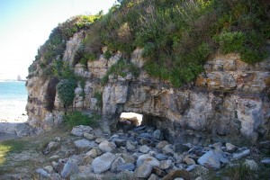
John Vonderlin: This Brick’s No Ordinary Brick

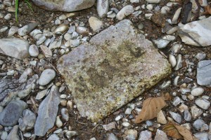
[Image: The partial brick John found. How did it get to the South Coast?]
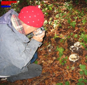
Story/Photo by John Vonderlin
Email John ([email protected])

Hi June,

Do you remember my posting that included a photo of a partial brick I had photographed in the gravel of Gazos Creek the day of Mike Merritt’s guided history walk in late August? Only little more then half a brick, with an imprint including a partial letter followed by the letters B A L L. Hoping to find out something about it, I emailed a brick collector’s website that encouraged questions. Unfortunately, the email I sent was from a master account on my computer, and I forgot to check that account for replies. So I missed the reply from Dan Mosier, an avid brick collector, and the helpful author of the excellent brick-oriented website. http://calbricks.netfirms.com/index.html Wander around this site for a few minutes and I’ll guarantee you’ll know more about bricks then anyone in your neighborhood. What Marine Debris is to me, bricks are to Dan.

Fortunately, Dan re-sent his missive recently. And I now know the partial brick is an antique archway firebrick, made in Derwenthaugh, Durham County, England, and probably shipped to California in the mid- to- late 1800s, as ballast in a ship that sailed the perilous 16,000 mile route around Cape Horn. Price upon delivery? Possibly free! Probably 10 cents. Certainly so cheap, that the Mid-Western brickmakers could not compete, when saddled with the prohibitive cost of overland transportation for just one-tenth that distance.

Even with all the facts I’ve learned about the remnant since Dan identified its manufacturer, it is still quite possible that it could have been used in the McKinley Mill in the 1870s, and then reused at the Gazos Mill in the early 1900s, as I had theorized in the “Strange Coincidence” posting.

Mr. Mosier was quite sure it was a SNOWBALL brick, made by the Snowball brother’s Derwenthaugh Fire Brick Works. When I looked at this photo on his website, so was I. http://calbricks.netfirms.com/brick.snowball.html An exact match.

Mr. Robert Piwarzyk, also an avid brick collector, whom Dan quotes on his website, has written a manuscript entitled, “The Laguna Limekilns: Bonny Doon.” An excerpt of that at http://www.santacruzpl.org/history/work/limefire.shtml explains the history of firebricks in California, particularly on our coast. And this helps to explain the possible usage dynamics that might have led to the SNOWBALL firebrick remnant being in the Gazos Creek. While his timeline and facts seem to support my multiple firebox use theory for the brick, he warns of the difficulty of interpretation of sites that have bricks. Then reiterates that with this quote , “…..Or, as more aptly stated in “Brick Bats for Archaeologists: Values of Pressed Brick Brands,” by Roger and Marsha Kelly: “…. Reuse of bricks is an important capability which may lead to ambiguous interpretations of chronology.” ”

Still, I’ve made up my story and I’m sticking with it. Enjoy. John
P.S. Mr. Mosier, also wrote an interesting email to me about the bricks used in the Pigeon Point Lighthouse, a subject that has had mystery and some controversy associated with it. He also suggested likely brickmakers for both the distorted bricks I posted a picture of a while ago and the bricks used in “Limey Kay’s” house. More on this soon.

Real soon. This is an excerpt about SNOWBALL firebricks by Mr. Piwarzyk in his manuscript.

“Comments: Several letter sizes and styles are known. Also comes in arch and wedge shapes. Noted in Kelly’s Directories Ltd. 1935. Have been found at five limekiln sites in Santa Cruz. Two fragments of this brick having a backward “b” (i.e. rotated) were found at the Laguna limekilns.” Hmmm. Dyslexic or drunk brickmakers? Or bored, rebellious workers? Good thing I didn’t work there. Though I’m sure future brick collectors would prize my clandestine efforts.

By the way I was able to find some of the Vital Statistics about the Snowball brothers. They were both listed as coalminers when they got married. I wonder if their wives had anything to do with their career change. Women and coal dust are not immiscible, but form a very unstable compound. Bricks? They are forever.
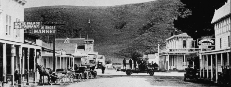
Posted in Dan Mosier, John Vonderlin, South Coast Brick | Tagged , | Comments Off on John Vonderlin: This Brick’s No Ordinary Brick

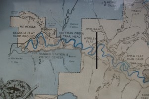
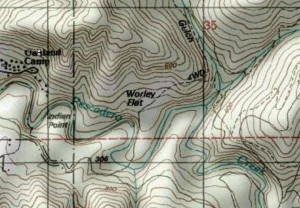
John Vonderlin: The Black Bar Shows The Possible Site of the Worley Dam Site

To play catch up on John Vonderlin’s earlier Worley Dam posts, please click here

Email John Vonderlin ([email protected])

Posted in Uncategorized | Comments Off on John Vonderlin: The Black Bar Shows The Possible Site of the Worley Dam Site

The Coburn Mystery: Chapter 57

By June Morrall


1893, the year of a “financial panic,” centered in the big cities.

In January, respected Pescadero pioneer Alexander Moore traveled to the state capitol in Sacramento to lend his last minute support for passage of the controversial Pebble Beach legislation, Assembly Bill 103. His presence was worth the trip; the so-called “Pebble Beach bill” passed the legislature unanimously, adding it to the county park system.

Loren Coburn had claimed the beach, and all of its shiny pebbles, but he was not in Sacramento to fight for it.

Why was that?

Apparently, an incomplete piece of legislation had been passed. Yes, the beach was now officially a public park—but the road, Coburn’s road, leading to the beach WAS NOT. There was no provision for a road or path or trail for people to use to get to the beach.

That problem would be dealt with later. In Pescadero there was much rejoicing. A “Grand Picnic” was planned for April, including San Mateo and Santa Cruz Assemblymen James O’Keefe and Bart Burke. The festivities closed with a “Grand Hop” at the Union Hall.

Everyone had so much fun, there was another big picnic scheduled for May, a “seashore banquet,” if you will,. Assemblymen O’Keefe and Burke were guests of honor.

When the time came,  Pescadero’s Dr. McCracken rose to speak:

“Ladies and Gentlemen,” he said, “today in Chicago the greatest fair and exhibit in the history of the world has been dedicated to the people….we are here to celebrate an important event to the people of this county, the dedication to the people of beautiful Pebble Beach. For over a year the people have been battling for their rights, and it had come to the time when they were to be protected in them. We have with us two gentlemen to whom, for this, we owe much., and will now take pleasure in presenting each with a charm made from a pebble from the beach as a slight token of the regard the people of Pescadero hold of their friends. As we love Pebble Beach so we hold in remembrance those who so valiantly assisted in the passage of Assembly Bill 103.”

———

(Image at the top of the story: 1893 minted in San Francisco Morgan Silver Dollar. Only 100,000 were struck, making this coin the rarest Morgan Silver Dollar.)

Posted in Uncategorized | Comments Off on The Coburn Mystery: Chapter 57

John Vonderlin: The Chutist (Two)

The Chutist, Part Two

Story & Photos by South Coast Explorer-Adventurer John Vonderlin

Email John ([email protected])

Hi June,

In Part 1, I was in such a hurrry to push my account to the point of reaching the location of Gordon’s Chute, that I left out a couple of “points of interest” that you will see along the way. As I previously wrote , after you’ve wound your way to where the beach comes into view, after having passed the ominous “Skull Graffitti,” scurried over the “Slime Pit” on the wobbly log,  inched along the slippery, precipitous “Inca Trail,” and finally struggled through the dense underbrush of the riparian corrider, into the open, you’ll see something I forgot to mention: A series of huge, parallel concrete blocks. They are the last remnants of the Tunitas Gulch Trestle, the figurative, and perhaps someday, the metaphorical “end-of-the-line” of the famous, but ill-fated, Ocean Shore Railroad. The blocks used to be heavily covered by bright blue and fluorescent,Tagger-type painted graffitti, but somebody, mercifully, covered those with a camouflage-style coating that seems to be getting less obtrusive as time passes. Might be me, though.

If you want to head towards the southern end of the beach, close to the trestle remnants, there’s a log that spans the creek, and with a little  balancing act, you can do it, no problem. If you can’t do that, perhaps the green coating of shoe- slime you picked up earlier on the “Log Walk,” will look tasty with an ample topping of white sea foam (a thick layer of the fluffy stuff huddles on the waters surrounding the good-sized tree you’ll be traversing)

But this time we’re going to head north. After reaching the sand where the creek, which had been hugging the base of the hill, veers westward toward the ocean, Meg and I discovered this wonderful bit of Ephemeral Beach Art.

Knowing that this area was a camping site for Portola during the famous 1769 Expedition, probably because of the Ohlone village that was once here, I couldn’t help but wonder if there is an Ohlone, or other  Native-American connection to this structure. It has wonderful lines,  seems to be easy to build, and when  thatched, would provide sufficient shelter under all kinds of skies. It’s fun to visualize how it might have been 500 years ago, on an overnight shellfish-gathering expedition from a nearby village to this special site, under the magical cliffs of Tunitas.

Now, 240 years after the Portola Expedition, I found myself walking and standing and thinking where the explorers may have done the same. I am not surprised by this feeling of “continuity,” if you will.  I am sure they enjoyed the same incredible views of the Pacific, the spacious sands, looming cliffs, and the ever-changing rhythm of the surf that is found here.

As we headed further north across the sand, a distance away from the sheer cliffs for safety’s sake, we encountered a tire, one of Tunitas Beach’s most common non-buoyant Marine Debris “aggravations.” I’ve observed tires being coughed up more frequently by “Neptune’s Vomitorium” at the north end of the beach, more than anywhere else on the Coastside. Then they slowly migrate south down the beach. Sometimes it takes months for a nubile tire to make the voyage; then it will vanish into the offshore Longshore Current (once again.)

The particular stretch of sand this tire was marring, was, and is, the province of Jim Denevan’s, aka, The Sand Man. I might have stepped onto his favorite practice area where he creates his world famous sand etchings. Alas, he seems to have stopped coming. Perhaps, this winter, when most sane folks are barred from access by the difficult terrain, I’ll spot his bare footprints leading away from his latest wonderful piece of art.
One hundred yards further, and we are standing at the gateway to Alexander Gordon’s Chute site. Only passable in a good minus tide, this “gauntlet-style” passage is coated with a healthy layer of many types of slimy algae, turning walking into a “pay-attention business.”

But we thought by hugging the cliff base, in the narrow band above the slime, and doing a timed-dash across the one, always wave-washed area, then clambering up a slick wall onto the terrace of the base rock for Gordon’s Chute, that we would be ready to launch our expedition into new, unexplored territory, the Tunitas sea cliffs, stretching north to Martin’s Beach. What I now call “The Forbidding Zone.” Home to many large sea caves, where some have tall-taled, suggested or perhaps revealed, sea monsters or other strange creatures might live. Certainly, it is one of the least explored, least written about and apparently never photographed stretches of our coast. I wanted to change that.

Up to this point, I had been feeling pretty confident about our plan and the planned route.  But, if you look carefully in the far distance of the gateway picture, above the base rock of Gordon’s Chute, you can see a huge spray of  whitewater. This is right at the low spot I was hoping to lower myself from the top of the base rock to the sand below next cove, and then use my little ladder to climb back up after probing north. Seeing this made me worried, and that was from a distance.  Next Part 3 The Base Rock, Chicken’s Roost Redux? Enjoy. John
Below is a page from the California Historical Landmark about the #375 Marker at Tunitas Creek;Tunitas Beach, Indian Village Site on Portola Route

Site Information

Approximate Location of the Indian Village Site
site photo
Landmark Number: 375
Location: Mouth of Tunitas Creek at Tunitas Beach, 1,000 ft west of Hwy 1, 6.8 miles south of Half Moon Bay, San Mateo County
Marker Plaque: none
Coordinates: 37.35664 N
122.3961 W

Coordinates based on NAD27 datum

Description

The Portola Expedition of 1769 discovered this Indian Village on Tunitas Creek in the southwest corner of Rancho Canada de Verde y Arroyo de las Purisima; the Rancho was granted to Jose Maria Alviso in 1838

Posted in Gordon's Chute, John Vonderlin | Comments Off on John Vonderlin: The Chutist (Two)

John Vonderlin: The Chutist (1)

[ Note to our readers: If you have a pc, you may have to imagine John’s photos at this time. You may see red x’s. If you have a mac, you should be okay. We are working on resolving the problem. They are really beautiful photos.]

The Chutist, Part One

Story/Photos by John Vonderlin

Email John ([email protected])

Hi June,

Our attempt during the extreme low tide (minus 1.4) a few days ago to probe northward from the former site of Gordon’s Chute into “The Forbidding Zone,” was a failure. We had hoped the combo of the low tide, nicely placed in the late afternoon, along with the presence of all the sand, not yet drawn into deeper waters by the winter’s waves, might provide us a virtual Camino Real northward below the cliffs, perhaps, right up to Martin’s Beach.

Realistically, I was just planning to use my little wooden ladder, a throwaway from some child’s bunk bed, to climb back onto Gordon’s Chute’s base rock after sliding down from it for a quick foray into the next cove, with its giant sea cave. Unfortunately,.the moderately large surf, spawned by a Pacific storm, that though driven far north by the developing High Pressure Center presently warming us, was still able to send its killjoy missionaries to squash my hopes, as I saw at first glance. Still, failure can breed success and having to halt, and go no further, on the base rock of Gordon’s Chute, made me give my newest Chicken’s Roost, a thrice over. A “Chute shoot” developed.

But before I can photographically bolster my rationale for allowing reticence to decide whether I should take a chance in the name of exploration, let’s get there first.

These first five photos are of the creek trail to Tunitas Beach. With the onset of substantial rain, it will washout, leaving only the slippery, steep trail straight down from the Highway 1 pulloff available.

After parking on Tunitas Creek Road just east of Highway 1, you head south along a dark, shady trail, beside and in a small concrete drainage ditch. The path gets steeper downhill, then cuts westward under the bridge. There you will be confronted by the angry guardian of Tunitas,

If you are brave enough to continue, you’ll soon have to pass the first test:: “The Log Walk.” Though only slightly longer then ten feet, the log walk is particularly treacherous because of the thinness of the log, the sliminess of the nearby mud that will be coating the bottom of your shoes, and the green scum that failure will coat you with.

The added trap of the seemingly substantial log parallel, alongside the main trunk, apparently available in case you should start to lose your balance, actually offers a long-to-be-recounted-with much-laughter, even if not photographically-captured, humiliation event.

From there it’s the Inca Trail, a narrow, muddy, slippery  hand-dug trail, that offers its own opportunities to put a damper on your beach visit memories, if you’re not paying attention.

Passing through that, you wind your way through almost a tropical forest.

During the winter some ambitious souls will hack a path leading up the hill above the flooded “Log Walk” and the washout of the “Inca Trail, allowing beach access.  Abandoned in late Spring, it is almost invisible, completely overgrown by Fall.

Continuing to hike through the riparian corridor as it emerges into the ever-widening canyon mouth, you finally see the goal ahead, Gordon’s Chute

the wave-washed end of the looming, sheer Tunitas cliffs. Next, Part 2 of “The Chutist,” or “Oh. Shoot! and the Chute Shoot.” Enjoy. John

Posted in Uncategorized | Comments Off on John Vonderlin: The Chutist (1)

Photographer Joel Bratman: Acid Beach & The Notch

Bratman has gone deep into Vonderlin territory.

To see Joel Bratman’s photos, please click here

Email Joel: [email protected]

June to Joel: Where did you shoot these pix from?

Joel to June:

Hi June,

I stopped at a couple of turnouts about half a mile south of Greyhound rock and pushed my way through thick shrub to get to the edge of the protruding bluff to take these photos.

Look for the portion of green shrub that extends out the furthest.  http://www.californiacoastline.org/cgi-bin/image.cgi?image=6419&mode=sequential&flags=0&year=2002 That’s where I took most of these from.

– Joel

Posted in Uncategorized | Comments Off on Photographer Joel Bratman: Acid Beach & The Notch

John Vonderlin: New Coastal Trail at Cowell Beach A Beauty

Story by John Vonderlin
Email John ([email protected])
Hi June,
A while ago I sent a posting to you about an adventure Meg and I had exploring “Secret Beach, a ways south of the Ritz Carlton.”  The highlight of that trip was clambering over and photographing Purisima Falls, where it drops into the Pacific. Not long after that I related that there were big plans for a blufftop trail from Cowell Beach to south of the Falls. Well, yesterday we drove by and found that the project is close to being done.
At the north end of this soon-to-be-opened stretch of the Coastal Trail, there is a path, though “road” might be a more accurate description, winding along the blufftops, south from the Cowell Beach access viewpoint.
At the southern end of the trail, across from the Bob’s produce building on Highway 1, there is a new parking lot, a new bathroom, and a path/road leading straight west to an overlook on the blufftop, just south of Purisima Falls.
Workers were still busy with various details along the path, so we decided not to get a “Sneak Preview,” but I did photograph the stunning Cowell Beach area. While I’m a little sad that such a hard-to-reach, and stunning stretch of our coast, which we considered “our little secret,” will now become accessible to hordes of people, I’m also delighted that it’s happening. I predict this new stretch will vault to near the top of list of places you’ll want to recommend to your friends who come to visit from out of town.
After surveying the ongoing work we walked down the newly-repaired stairs from the Viewpoint to Cowell Beach.
There I photographed these two odd chunks of metal, seemingly deliberately placed there as “works” of art.
I suspect there is an interesting story behind these mysterious relics ending up close together at the bottom of the stairs. Heavyweight artistic statement? Last remnants of a shipwreck, pulled from the sand or surf?
One appears to be a gearbox that was hooked up to a large motor. The other reminds me of the fixture on boats that allows multiple lines to be fastened to it. Maybe some kind of giant “cleat?” or “bollard?” As the son of a sailor, I probably should be embarrassed at my lack of the right term, but I’ll research it. Just a couple bits of oddness on a spectacular, quarter-moon-shaped, soft-sand beach, bounded by steep cliffs, and the cold, moody Pacific, with no other sign of civilization visible, but the stairs you climb. down.
I’m sure there will be a big opening ceremony fairly soon after the trail has been completed. I’ll be looking forward to using the path, thereafter. It should be interesting to see what kinds of photographs of the Falls start showing up online.  Enjoy. John
Posted in Uncategorized | Comments Off on John Vonderlin: New Coastal Trail at Cowell Beach A Beauty

Aug 1928: Eli D. Moore Passes

From the “Redwood City Standard,” August 2, 1928

“Eli D. Moore, California pioneer and the oldest member of the Native Son’s order in San Mateo county, passed away at his home in Pescadero Monday. His last illness was the first serious one he had ever exerienced. He was bed-ridden for only two weeks in his vine-covered cottage that he had made his home in the picturesque coastside town for so many years.

“Moore was born under the Mexican flag at Santa Cruz, December 12, 1847, on the land purchased by his grandfather, Eli Moore, from Jose Balcoof. This is believed to have been the first instance of transfer of land in that section to an American. Moore was the son of Mr. and Mrs. Alexander Moore, immigrants to California from Missouri in 1847. The family lived first at Mission San Jose and then at Santa Cruz, moving to Pescadero in 1850, where they later secured large land holdings.

“In 1876 Moore married Miss Ellen McCormick, member of another well-known pioneer family of the coastside. Of several children born to the couple, only one is living, Edmund Moore. There are two surviving brothers: William A. and J.L. Moore, both of Pescadero, and a sister, Mrs. Charles Steele. Dave Moore, a third brother, passed away in this city last year….Interment was in the family plot in Pescadero.”

Posted in Eli D. Moore | Comments Off on Aug 1928: Eli D. Moore Passes

John Vonderlin: “Holes in Pescadero” (Part 2A)

Story & Photos by John Vonderlin

Email John ([email protected])

I believe the Worley of Worley Flats  fame (almost) was William L. Worley. In “San Mateo’s 1870 Federal Census, Page 410B, Sixth Township, Post Office Pescadero” there is only one listing for a Worley. He was 47 at the time. He listed his occupation as a farmer and his birthplace as Tennessee. That fits with Dr. Brown’s book’s decription of Worley Flats’ name’s origin timewise.

Hi June,

Since I learned about Pescadero’s, “Biggest Hole That Never Was,”  a few weeks ago, my mind has been traveling down some odd, speculative paths.  My discovery of the almostness of this proposed behemoth’s existence,  followed by a visit to the site where it might have been, and some subsequent contemplation of the possible present state of my favorite playground, The Coastside, had this dream come to fruition, has me thinking about forks in the road not taken.
It was while reading about “The Stage Hole,” in Dr. Alan Brown’s 1960 book, “Place Names of San Mateo County,” that it started. Dr. Brown mentioned in his brief notation about ,”The Stage Hole,” that  the old stage road had run across what he knew in the present time (1960) as Nunziati’s dam. That was before the old road was abandoned in 1859 to be replaced by the appropriately and still-to-this day-named Stage Road.
While websearching, using “Nunziati and Pescadero” as a search phrase, I found a posting on a forum that included  three old local newspaper articles from 1970, about  the Army Corps of Engineers, holding public meetings on seven different proposed dam construction sites in the coastside watersheds near Pescadero.
Their favorite possible site was the so called Worley Flat option. They were proposing to build a 233- foot- high earthen dam, on Pescadero Creek, at Worley Flats, about 1 mile east of Memorial Park, roughly eight miles inland.
When a series of public hearings were held to discuss the options, a Mr. Nunziati, spoke strongly of the benefits that would proceed from a Worley Flats Dam. Those might have included a better-then-Hetch Hetchy quality, reliable, water source for everybody in the watershed below the dam and far beyond, up and down the Coastside, a lake-based, tourist magnet, with a wide spectrum of possible associated recreational opportunities, and the nearby jobs they would create, and of course the peace-of-mind-security, upper watershed flood control dams gift the population they overlook, in those tense “The Storm Door is Open,” periods, that can last weeks, in the mountains along our coast, during wet winters. From his position on the Water Committee, his voice was well heard in the public hearings about the proposed dams.
If this is the same Mr. Nunziati, who used the small storage ponds, of which, “The Stage Hole,” is one, to grow crops around Round Hill, it is easy to see why he believed strongly that a dam was the answer to his and many other local farmers’ water problems, and that it would have been a boon to  this area.
Since we all know there is not a “Richard Milhous Nixon Dam” on Pescadero Creek, I won’t bother  relating the few details I know of the public’s reaction, almost forty years ago, to what they considered a  seven-headed Hydra, come to kill their way of life.
However, I woud like to relate the details of a trip we recently took to the site of the proposed Worley Flats Dam. (I made up the part about Nixon, but he was a popular President at the time the project would have been named, and we would have been stuck with the name thereafter.)
Here are a couple of screengrabs of a U.S.G.S. map of the Worley Flats area.

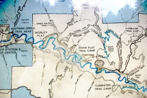
On the second one, I’ve used a “black bar” to approximately where the dam would have been. The reservoir would have been bifurcated, with one arm going up Jones Gulch and the other going up the canyon that Pescadero Creek flows through. I’ve also attached a photo of the Park’s kiosk map.

I should mention that my friend Meg’s house sits on a cliff sixty feet above Pescadero Creek, about a mile downstream from the proposed dam site. We’ve speculated about the type of dam failure that would sweep her home away. I bet on a spectacularly rainy stretch in late-winter, the creek running high, roaring over the dam’s spillway when, an 8.7  earthquake along the San Gregorio fault, triggers a general collapse of the dam’s face, unleashing 50 billion gallons of water in a matter of minutes.
Reading a bit about the thousands, yes I said thousands of failures of earthen dams in the United States throughout history, particulary the details of the Johnstown Flood, our worst dam disaster, I came to realize it wouldn’t need a rare set of circumstances.
This excerpt from Wikipedia about the Johnstown Flood explains why
“On its way downstream towards Johnstown, the crest picked up debris, such as trees, houses, and animals. At the Conemaugh Viaduct, a 78-foot (24 m) high railroad bridge, the flood temporarily was stopped when debris jammed against the stone bridge’s arch. But after around seven minutes, the viaduct collapsed, allowing the flood to resume its course. Because of this, the force of the surge would gain strength periodically, resulting in a stronger force hitting Johnstown than otherwise would be expected.”
I suspect all the giant redwoods still left in the Pescadero watershed might cause the same effect; forming a series of logjams, with  temporary lakes a hundred feet deep, flooding the canyon behind them, only to have them break, unleashing a wall of water laden with its crushing debris.
For the tens of thousands of people seven miles downstream, who might have lived in the “Nixonville Flats,”– the suburb that might have grown up around “Old Pescadero”– in the nearby, drained and filled marsh areas, there would be scant warning. Only the occupants of the upper floors of the large condo towers in town would be unscathed.
Still, while the fate of submersion seemed a remote possibility for Meg’s house, with a failure of the Worley Flat Dam, it was actually part of the plan in another of the proposed dam sites. The Five Mile site, so called because that’s how far inland from the coast it was to be built, would have left Memorial Park and Meg’s house somewhere at the bottom of the lake. But, that will be addressed in a future story about “The Holes of Pescadero.”
The Worley Flats Dam Project was probably the Worleys’ big chance for immortality. While they’re already way ahead of me, what with a flat named after the family, this ws their chance to make the “Big Time.”The thought of generations of knowledge-thirsty school-age children, by the endless busload, visiting the dam and asking: “Who were the Worleys?”…and having their teachers respond with well-prepared answers about the Worleys, lives would have cemented their place in history. That is, unless, the schoolchildren were there to visit the memorial at the sundered remains of the dam, whose failure had wiped out all the good citizens of Nixonville/OldPescadero, thereby learning a valuable lesson about misjudging the power of Mother Nature. Or “Pulling a Worley” as such errors might have subsequently become known locally.
Under the heading of “The Worley Field” he states: “A clearing on the N bank of Pescadero Creek about 3/4 above Memorial Park; Worley is said to be the first settler here in the 1860’s or 70s.”
Next a visit to where it ain’t, but might have been. if a different fork in the road had been taken. Enjoy. John


Posted in Holes in Pescadero, John Vonderlin | Comments Off on John Vonderlin: “Holes in Pescadero” (Part 2A)

There’s this “Hole in the Wall” Photos by John Vonderlin

[Note: If you could not enjoy John Vonderlin’s stunning “hole in the wall” photos in his earlier post of the same name–because there were red x’s there instead of beautiful images–you should be able to see them here now. My apologies to John and to my readers.]

All photos by John Vonderlin
Email John ([email protected])

Hi June,
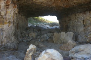
These are the original files of the Hole in the Wall at Four Mile Beach. One is looking seaward, one landward. Hope they come through. Enjoy. John

Posted in Hole in the Wall, John Vonderlin | Comments Off on There’s this “Hole in the Wall” Photos by John Vonderlin