[Note: It’s taking me so long to punch out the chapters of this very long story because my original ms is covered with scribbles, etc. ]
By June Morrall
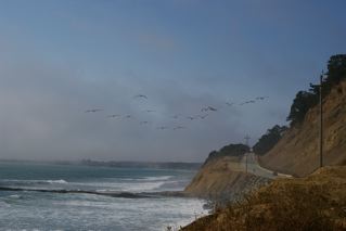
The stages picked up passengers headed for the Coastside at the San Mateo train station. The typical route closely followed present-day Highway 92. [I say that loosely.] There were stops along the way, marked by drinking establishments, and according to legend, the places where the stage drivers downed whiskey to help them finish the first leg of the trip, the Occidental Hotel in Half Moon Bay–then called Spanishtown because of the large population of Spanish-speaking residents.
In Half Moon Bay, the horses were fed and watered, and the drivers consumed more drink at one of the many saloons in town, before delivering the remaining passengers to Pescadero, and most likely to the Swanton or Pescadero House, both bed & breakfast establishments.
By then, again according to legend, the drivers were pretty high on drink, and raced from Spanishtown to Pescadero, along the still-bucolic Stage Road (which had a different name at the time–for example, the main thoroughfare in Pescadero was called San Gregorio Street, a name changed in the 1970s, I think, and not by the locals.)
Like today, when the stage entered Pescadero from the north a hundred years ago, the first building to come into view was the tall spire of the white Congregational Church, one of the oldest in San Mateo County. (I was always look for it when I take that beautiful, still timeless ride.)
Some of the passengers didn’t stop in Pescadero; they were headed south to Santa Cruz, and the stage took them there three times a week.
Most of the visitors and business people who took the stage from San Mateo to Pescadero were regular folks, who couldn’t afford their own carriages—the “well-heeled” rode over the mountains in fancy horse-drawn vehicles of all kinds. At one time the Swanton House was reputed to be the gathering place for the railroad barons and the silver kings, the very wealthy who lived in San Francisco mansions–with names like Flood, Crocker and McKay.
Posted inUncategorized|Comments Off on Coburn Mystery: Chapter 30 (Original Draft)
journal entry at Pescadero Memories regarding your attempts to access Acid Beach. I am very familiar with The Notch, Acid Beach, Trefiret Beach, and AMB’s beach having been to all four, and the latter three on many, many occasions beginning around 1993 or 1994.
In fact, I know exactly how the beaches were named. A friend of mine, and co-explorer of that portion of the coast, named that northernmost of the three beaches “The Notch” in the Coastal Records Project, literally after a notch in the cliff above that beach. The actual notch is visible, as I recall, looking to the south from the turnout in US1 directly above Acid Beach. A promontory extends out perpendicular to the coast and the notch is cut in to the top of the promontory, maybe a dozen feet wide and deep.
I was surprised to run into someone at the bottom of Acid Beach once back around 1994. This person (Steve) had accessed that beach on numerous occasions. He called it “Acid Beach” because he enjoyed “partaking” there. So while the naming may not have a direct connection to Ken Kesey, it was named by a kindred spirit! My friend/co-explorer denies naming the beach in the Coastal Records Project, but I am dubious.
My friend named “Trefiret Beach” after me. Trefiret is simply an anagram of my last name, Fitterer. I was appalled at the naming, by the way, and would have chosen a more appropriate descriptive name instead.
I believe I designated AMB’s Beach in the Coastal Records Project. A stake was driven in the ground at the lowest point of the cliff above AMB’s Beach, presumably for rappelling purposes. Behind the stake, about 50 feet away, is (or at least was) a homemade sign which reads: “AMB’s Beach – Monty Parker’s favorite spot.” I don’t know AMB or Monty Parker, but given that they had reached the before before me, I thought I would pay tribute in the Coastal Records Project.
Regarding beach access, I will address each in turn. First, I reached The Notch only one time. That was in 1993 or 94, and I accessed it from Acid Beach to the south at a very low tide. If you stand above Acid Beach at the turnout in Highway 1 and look at the north end of that beach, you will notice a very significant arch. 15 years ago, you could walk through the arch to the north at a very low tide, and then scramble along the base of the cliffs to the north of the arch to access The Notch. However, the sand levels have eroded to the point that this access is no longer possible.
In the past, Acid Beach could be accessed by descending from the top of the north end of the cove (in front of a sprawling pine tree) and in line with the large arch. You could walk over the arch and then descend to the beach mainly in a southerly direction.
Unfortunately, the arch has eroded to the point that I no longer feel comfortable crossing it. You can safely exit Acid Beach by ascending from the south end of the main cove (i’m comfortable ascending the south end but not climbing down). A description here would be too difficult. Better to describe in person (more on that in a bit).
Trefiret Beach/Warm Water Cove/Amb’s beach, as you know, are all accessible from Scott Creek. I call the route the “Scott Creek Obstacle Course” for reasons you must know well by now.
It is possible to access Acid Beach from Warm Water Cove. Here’s how. Refer to the first picture in your post entitled “Third Time’s The Charm” from February 24th. You need to proceed north around the back of the cove. As you reach the base of the peninsula that extends out in a southerly direction, you can climb onto a ledge about 8 feet high and walk along that ledge all the way out to the big arch.
At that point, you are at the base of a steep scree slope. It’s pretty scary, but it is possible to ascend that slope to the top of the ridge visible in that picture. There ain’t no goin’ back, however! Once you climb, you are pretty much committed to going the rest of the way. The way down and north is pretty obvious from the ridge.
Once you make your way around to the south end of the south cove at Acid Beach, you have a choice: (1) negotiate a ten foot or so drop into the cove, or (2) back up a bit and drop into waist/chest deep water and trudge into the cover. With much experience, I can say that Option 2 is far safer and easier to do.
It’s pretty easy from there. You go to the back of the cove, climb over a tunnel at the north end of that south cove and then pick your way into the main cove at Acid Beach.
I haven’t made this trip in a few years and would love to do it again. I would especially love to go with someone else but have never found anyone interested in accompanying me (my wife and buddies are not particularly adventurous).
Please let me know if you have any questions. I would be happy to write back or call if that’s easier. Also, it would be great to make the trip from Scott Creek to Acid Beach with you. Let me know if that’s of interest, and we can plan a trip around the tides.
I’m glad to know you are connecting in an intimate way with this beautiful, desolate section of coast.
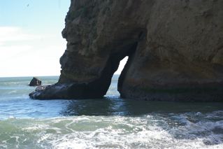
I was reading the presentation by “Save Our Shores,” entitled, “A Geologic Train Ride Down The San Mateo County Coast,” when I came upon an interesting photo. It’s of a very attractive Sea Arch just south of Martins Beach. This stretch of coast from Martins Beach to the site of Gordon’s Chute at the northern limit of Tunitas Beach is inaccessible except by watercraft. Which is probably why the photo was taken from an aircraft. The caption says the arch collapsed due to the Loma Prieta Earthquake of 1989. I thought that gave it some special cachet, and the Sea Arch deserves mentioning even though it’s gone.
If you’d like to see the before and after you can do so on the California Coastal Records Project website.
The arch appears in the 1972 (#7218025), 1979 (#7928064). and 1987 (#8713158) photos and is gone in the 2002 (#6190) photo.
Well, not entirely gone. When you click on the 2002 photo, to access the large file photo, you can see the missing pieces lying in the shallow water, the surf busting over them. An inglorious, but inevitable end considering the forces of Nature this feature faced. I wonder how many other of the disappearing arches of our coast suffered the same fate from the frequent (geologically speaking) earthquakes that shake our coast?
When I kayak down this part of the coast this summer, I’ll be sure to get a picture of this spot. I wanted to investigate the huge sea cave just to the right of the former arch’s spot on the 2002 picture (#6190) anyway.
By the way the dark spots above the white areas on the cliffside are birds. You can see them perching on tiny ledges all along here in the pictures. I’m not sure what species. Enjoy. John
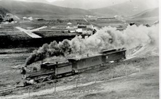
Mr. Vonderlin, I’ve enjoyed reading Half Moon Bay Memories and El Granada Observer as well as your Pescadero Memories, particularly references to the OSRR, which I became acquainted with in the late 1920s.
My uncle took my brother and me on a hike along the right-of-way from Thornton to Mussel Rock. Though the rails had been torn up, still it was obvious a railroad had been there.
In 1939 I made several bike trips down the coast from San Francisco, once climbing to the top of the collapsed tunnel at Pedro Point to view the grade south to Devil’s Slide. And I also drove to Santa Cruz in a friend’s Model A Ford, borrowed from his brother, always looking for OSRR remnants.
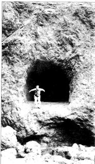
At Pescadero beach it looked like grading of the dunes had been done south of the “mysterious tunnel” bluff you described. On a much later visit I found the tunnel portal, and since the grading I’d seen earlier would have led to the tunnel site, I surmised that the OSRR had built the tunnel either as a pilot bore, or to use it to blow down the hillside for easier grading.
Your north portal pictures puzzle me as they don’t appear to coincide with this surmise. I’ve never seen anything about this in the OSRR literature.
Re the Palmer Gulch Trestle: I have a photo of it given to me in 1939 that shows the trestle had already started to sag in the middle. About 1960 a friend and I hiked down to it; by then it was sagging noticeably. On the north side was a large, weathered (tool?) box, about 12’x4’x4′ roughly. It had an old padlock on it which we left as is.
We walked across the trestle, and my friend took pictures, of which I have a couple. Unfortunately, they are now badly faded (Polaroid camera?). but the rotted ties are still evident. I don’t believe it burned down because I saw an internet picture of it taken a few years after our crossing, and it was in nearly collapsed condition, and the text said it totally collapsed shortly after. Regrettably I didn’t add it to my OSRR “favorites,” and have never found it on the Web again.
Thanks again for your interesting memories of the San Mateo coastside.
Hi June,
I received this interesting email today. It reminded me the tunnel (s) story is not a mystery solved. I’ll get back to it. The gentleman from the cemetery has said he’ll show us it, so maybe it exists. I sent Angelo a picture of a burnt timber, though that might have happened after collapse. I loved that he lives in Sebastopol. I used to have a wonderful ranch/family orchard in the hills west of town during the Seventies. George Lichty, the cartoonist of “Grin and Bear It,” fame lived across the street. The Thomases who owned the American Opinion Bookstore (John Birch Society–remember them?) were at one corner, two gay interior designers from S.F. on another and a schoolteacher couple who were Sufis on another. A great time in my life to recall. Where has my youth gone?
Larry Fitterer and I are going to be lowering ourselves down the cliffs into “The Notch” and Acid Beach on April 9th or 10th. Yee-Haw. Hopefully, I won’t break my typing fingers or anything else. Enjoy. John
Hi June,
My guess is that the first European set foot in what is now San Mateo County on October 20th, 1769. They almost surely did so on what most people call Bradley Beach. That first person was probably a scout for the Portola expedition, ranging ahead of the main expedition, which reached and made camp at the mouth of Waddell Creek on that day.
As we set out from the camp a very long slope presented itself; this we had to ascend after crossing the stream which flowed at the foot of the hill to the north. It was necessary to open the way with the crowbar, and in this work we were employed the whole morning. We afterwards travelled a long distance along the backbone of a chain of broken hills, which sloped down to the sea. We halted on the same beach at the mouth of a very deep stream that flowed out from between very high hills of the mountain chain. This place, which was named the Arroyo or Cañada de la Salud, is one league, or a little more, from the Alto del Jamón. The coast, in this locality, runs northwest by north. The canyon was open towards the north-northeast, and extended inland for about a league in that direction.
From the beach a tongue of land could be seen at a short distance, west by north. It was low, and had rocks which were only a little above the surface of the water.
To the Cañada de la Salud, 1 league. From San Diego, 177 leagues.
(Picture #6402 at California Coastal Records Project [CCRP] showing the bluffs and the valley behind them shows why the weary explorers would have picked this wonderful spot to rest. The tongue of land he was referring to is Ano Nuevo Point)
Saturday, October 21.
We rested in this canyon while the scouts employed the day in examining the country.
Observed with the English octant, facing the sun, the meridian altitude of the lower limb of the sun was found to be … 41°41’30”
Astronomical refraction to be subtracted … 1′ Inclination of the visual [horizon] in consequence of the observer’s eye being three to four feet above sealevel, subtract … 2′
Semidiameter of the sun to be added … 16′ 13′
Altitude of the center of the sun … 41°54’30”
Zenith-distance … 48°5’30”
Its declination at that hour was … 11°2’3″
Latitude of the place … 37°3′
During the afternoon and night heavy showers fell, driven by a very strong south wind which caused a storm on the sea.
(You’ll note in Picture #6402 of Waddell Creek in the CCRP pictures that the latitude of this spot is actually 37 degrees 5.69 minutes. Still, to be so accurate with such primitive instruments is a testimonial to the skill of these explorers)
Sunday, October 22.
The day dawned overcast and gloomy; the men were wet and wearied from want of sleep, as they had no tents, and it was necessary to let them rest to-day. What excited our wonder on this occasion was that all the sick, for whom we greatly feared lest the wetting might prove exceedingly harmful, suddenly found their pains very much relieved. This was the reason for giving the canyon the name of La Salud.
(It is interesting to note in Father Crespi’s, Portola Expedition diary that he mentions this place was initially named the “Valley of San Luis Beltran,” and only after many of the sick recovered so quickly, despite a sleepless night in the cold rain of that late October day, was it renamed “Valley of Good Health.”
(Saint Beltran had been an early Dominican missionary in Colombia noted for his defense of the Indians against the more greedy and violent colonialists)
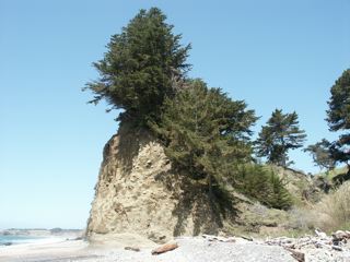
Here’s a picture of what that first scout, probing the beach to the north for the best path, would have seen.
The rock projecting into the ocean in the foreground is known as “Alligator Rock”. In the background we see Ano Nuevo Point and San Mateo County. On the right are the Waddell Bluffs.
“Alligator Rock,” so named because when the tide is in, it looks like a partly submerged alligator lurking watchfully for any unwary prey.
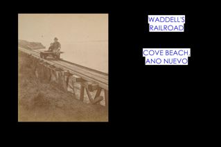
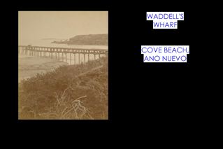
Waddell Bluffs is named for William Waddell, an early settler and lumberman from the nearby coastal mountains. He built a sawmill up Waddell Creek, in what is now Big Basin State Park. The cut timber was hauled in mule-drawn carts on wooden rails through the canyon to the coast for shipping. His plans for a wharf at the mouth of Waddell Creek were foiled by bedrock that made it impossible to drive piles for a wharf, so he extended a tiny rail line north to Cove Beach on Point Ano Nuevo.
From there he built a 700- foot long pier into deep water.
A swinging chute at the end loaded lumber onto awaiting schooners. Built in 1864, Waddell’s wharf was moving two million board feet of timber three years later.
After successfully conquering all the dangers of logging the mighty redwoods and shipping them off to market in rickety boats, Mr. Waddell was tragically mauled by a grizzly bear while deer hunting, soon after dying of complications in 1875.
The Bluffs themselves have left a longer lasting legacy. They, and their continual landslides, served as a natural barrier to transportation to the north, turning the routes that fostered major development inland to the Santa Clara Valley, leaving much of the Coastside undeveloped.
Even today, Highway 1 remains gripped in a perpetual battle with the ever-eroding talus slope of the Waddell Bluffs. Every year between 17,000 and 26,000 cubic yards of sliding material is removed, and then dumped onto the western side of the highway, keeping the road clear, and preventing it from falling into the sea, as the soil, and rock below it, are carried away by waves.
At the turn of the 20th century, road-builders were not so successful. Stagecoaches, carriages and wagons had to time their arrival to this stretch of beach at low tide. For about three quarters of a mile north of Waddell Creek, they would have to proceed over the recently wave-swept beach.
At the halfway point of this risky traversal, they reached what was known locally as “Cape Horn.” (Named after the tip of South America because of the extremely difficult, dangerous trip rounding the continent in the icy storm infested waters.) This was a continually sliding area just above Alligator Rock. There they had to temporarily leave the beach and climb a steep, rutted path across the landslide rubble from the Bluffs to get around a promontory. Fresh landslides stopped traffic north and south until the rubble was cleared.
In this century, to put your foot on the most southerly stretch of San Mateo County’s beaches you must climb down the large riprap boulders where “Cape Horn” was, just feet south of Alligator Rock. You can see it and the nearby parking spot in
Reaching the beach, head north, and after about two hundred yards, you’ll reach the Promised Land of Saint Matthew, for whom San Mateo County is named.
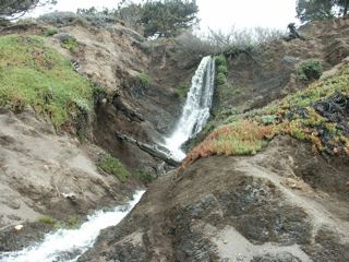
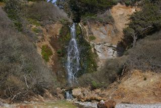
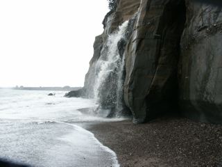
Continuing north you’ll soon come upon Wilson Falls, the most southerly waterfall in San Mateo County.
Not much further is the more picturesque Elliot Falls
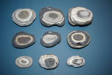
As you are walking along, you might want to look around for the rocks that I call “eyeballs.” They are black chert nodules with layers of white material. Differential erosion often leaves them looking like eyeballs.
The local Ohlone Indians gathered the large, solid pieces of black, glassy chert, and used them for tool manufacturing, or for trading items with inland tribes.
Several times while walking this stretch, I’ve met geologists who told me this area is a good source of “agatized whale bone.” Not having the tools, time or desire to convert the dull rocks they showed me into polished specimens, they remain a mere curiosity.
As we head further north we come to a place where the beach narrows considerably, disappearing entirely at high tide.
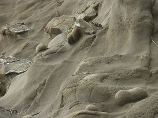
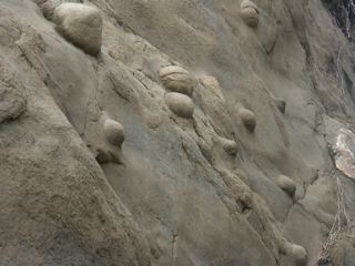
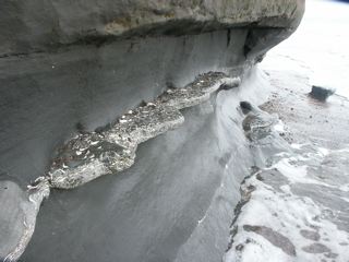
Look up at the Cliffside, and you’ll notice a number of concretions, many spherical, a few dumbbell-shaped, partially eroded from the soft rock.
If the tide is favorable you can continue northward, and in a few hundred yards you’ll view Finney Falls, the only waterfall I know besides Pfeiffer Falls in Big Sur, that drops right into the surf at times.
Because it’s partly fed by irrigation on the coastal terrace above, Finney Falls can be flowing during anytime of the year, though winter is best. Watch for concretions, layers of fossils
or scattered individual ones in many places in the cliff. Be aware though that this whole stretch is very unstable, and it’s common to find a new cliff collapse whenever I visit.
Continuing northward you’ll reach New Year’s Creek. At this point climb the path that will take you across the old bridge and back to the free parking spot on Highway 1, or continue to the end of the beach where the most southerly arch in San Mateo County is located.
This is also near where the pictures of Waddell’s wharf and railroad were shot. Waddell’s warehouse and lumberyard stood Just above you on the blufftop.
Nearby there’s a path that heads up to the trail on the bluffs that heads northwest to the Elephant Seal rookeries on Ano Nuevo Point. Usually, after the 31st of March, the trail is open without the need for a docent guide. Or you can head back to the main parking lot and Ranger station. Enjoy. John Vonderlin
Posted inJohn Vonderlin|Comments Off on The Coastside’s Southern Entrance: Story & Photos by John Vonderlin
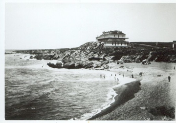
After church on Sunday afternoons, the Fourth of July–or, for no special reason–the Pescadero folk announced a picnic at Pebble Beach. Picking the pebbles became a pretense, sharing the experience of being together replaced the village Town Hall.
Pebble Beach became the fabric that held the close-knit community together.
Simultaneously, the pebbles attracted visitors from as far away as Maine, outsiders who needed a comfortable place to stay. Mrs. Sarah Swanton offered them rooms in a row of charming white cottages, smothered with blood red roses and trailing green ivy.
(An alleyway separated the six cottages called Fern, Myrtle, Rose, Ivy, Elm and Woodbine. All of the cottages opened onto a common garden filled with blooming flowers and shrubs. Beyond the garden was a wide promenade. Owners Charles and Sarah Swanton lived in the main house with their two children, Frank and Eva.
The Swanton House, owned by Sarah and Charles Swanton, stood at the corner of San Gregorio Street and Bean Hollow Road, names that have changed over the decades. Travel writers described the bed and breakfast as a “plain country hotel with a good table,” which meant Sarah was a pretty good cook. Old fashioned hospitality kept families returning to Pescadero but it was especially popular with women.
The flagpole–a significant marker by which everyone marked distances–stood in front of the hotel. It was a part of everyday life, always mentioned when giving directions to strangers. And there was a story behind the flag made of store-bought blue flannel with the stars sewn on in the 1850s by the town’s leading ladies.
To the south stood a landmark ridge that the locals called Lincoln Hill, named for the famous president, giving away the town’s Civil War sympathies. [I mention this because many & briefly, in San Francisco, were pro-Confederacy.] Union Army General Frederick Steele was a close relative of the Steele family, prominent dairymen at Ano Nuevo, south of town.
Wooley & Taft’s stagecoach picked up passengers daily at the San Mateo train station on the opposite side of the tree-covered mountain. The stage drivers, with reputations as hard drinkers and daredevils, careened over the hills.
Posted inCoburn Mystery|Comments Off on Coburn Mystery: Chapter 29 (Original Draft)
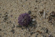
More photos of things we saw on the trip to Secret Beach.
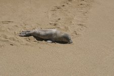
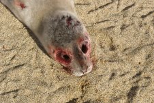
1) Finding complete sea urchins with spines intact is rare in my experience. Finding twenty of them in a hundred foot stretch of beach was an oddity I have no explanation for. 2) This cute little fellow had made this odd trail down the beach some time after high tide a few hours before. It didn’t seem to be aware of our approach, so I went close enough to observe if there was a problem I could help with, like fishing line entanglement. It’s eyes were open, but unresponsive. While I was walking back a few hours later I wondered if I should move it closer to the water or call the Marine Mammal Center for a rescue. Two vultures told me that wouldn’t be necessary.
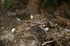
3) Nature can seem horrific, if it’s not a food source we utilize. I’ve been told the high protein eyes are usually the first to go on fresh marine mammal carcasses. 4) The short inlets eroded into the cliffs by seasonal streams had a lot of floats in them. As many float collectors as there are, that tells me few people come this way.
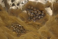
5) Limpet Town. I occasionally see shallow depressions in rocks filled to their edges by a limpet colony. Two together is highly unusual.
Hi June,
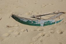
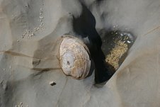
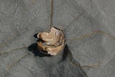
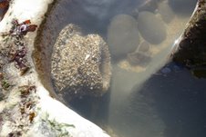
Here’s some more photos from the Secret Beach trip.
1) This remnant of a wooden boat had letters attached to it at one time that seem to spell Coos Bay, a harbor in Oregon. I’m going to try to find out if any boats from there were abandoned or sunk recently. It looks pretty fresh. 2) This is a typical fossilized clam found along our coast. I saw hundreds in the rocks during the walk.
3) This is a fossilized/agatized clam that we found in one small area. These are much rarer and older then the typical fossil clams found in this area.
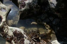
4) This is the largest sea anemone I’ve seen on our coast. Its size when opened up would be impressive.