The Ohlone: John Vonderlin Begs To Disagree

Story by John Vonderlin (email John: [email protected])

o5.jpeg

Hi June,
The email I recently sent you about the rocks that were probably polished by the mud-soaked flanks of mammoths and bison rubbing against them, reminded me of another rump-rounded rock a lot closer to home that I stumbled on a few years ago.

I had recently bought my first digital camera, a high dollar “prosumer” Minolta model that was a “steal,” thanks to a clerk mis-marking a floor model being cleared out. Without any particular talent or much experience, but having a high-tech camera with an awesome lens, I embarked on a mission of photographing everything I could find of interest. I was working my way through the various open space preserves in San Mateo County, when I visited the Russian Ridge Open Space Preserve.

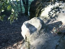
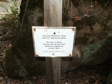
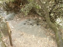
While wandering near Alpine Pond, photographing everything in sight, I stumbled upon a rock with grinding holes in it, made by the Ohlone Indians. There was nothing secret about this rock. It was visible from the path and a small sign requests respect for the Native American site, forbidding alterations of any sort.

o3.jpeg

Looking for a good shot (and feeling that I was helping to preserve, rather then alter anything), I cleaned out the holes, which were clogged with debris and took a few pictures. Later, I learned from a newspaper article about docent walks in the area, that this rock is called “Gossip Rock,” though I find no mention of it on the Internet.

Thinking that where there is one such special rock, there are usually more, so I scouted the nearby woods and photographed other rocks, also marked with grinding holes.

But, it was when I started checking out the huge boulder looming above Gossip Rock, just across the trail, that I made an intriguing series of discoveries. First, climbing up the hill on the west side of the boulder, I found, at waist level, a protuberance rising from the rock, topped by a chalice-shaped manmade feature. One edge of the “bowl” was missing but it appeared to have been so perfect at one time that I assumed it had to be manmade. Above it I noticed the rock was much smoother then the surrounding rock.

Fascinated, I clambered to the top where I found a hollow in the rock that was the size of a small bath tub. It was also filled with debris, but looked like it might have held a decent amount of water at some time, especially after I cleaned it out.

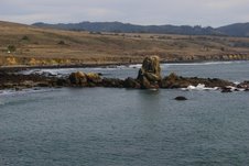
From the top of the rock, I could see Gossip Rock some 50 feet away. Looking down, I saw another smoothed, chute-like area that descended to the ground. I remember thinking this was either an Ohlone ceremonial site or their version of a children’s play area.

Knowing that the year ‘round, ridge-top springs, now submerged by the dammed Alpine Pond, must have made this a very attractive area, particular in the summer, I assumed this must have been a permanent settlement. High above the heat of the valley on one side, balanced by the damp coolness of the fog on the other, it must have been an idyllic place to prepare the winter’s larder of acorns.

It’s not surprising that in the 1930s California Governor James (Sunny Jim) Rolph christened a nearby beautiful knoll his “Summer Capital,” building a home adorned with a gold-painted, paper- mache dome.

My guess is the spacious pond, created when the dam was built, has submerged whatever Indian village or camp that was there.

o2.jpeg

A few months later, I attended a fascinating lecture in San Jose about the Ohlone Indians. I gave the photos of my find to the state parks scientist delivering the talk. He said he assumed the “offering bowl” was a concretion. Being a collector of concretions, and quite knowledgeable about them, I demurred.

Later, I contacted another state employee connected with Ohlone research. He said there was no tradition of rock carving by the Ohlone and identified the “bathtub” as an artifact of the acid in oak leaves that had, over time, eroded it.

Neither expert explained to me why these features existed on a rock near a Native American site, something I have never seen before. No matter what they said, my imagination told me otherwise and I continued to contemplate other possibilities for this unusual rock.

I filed it away until last year, when, my friend, Meg, showed me an article about a docent who leads nature walks in that area. The docent identified “Gossip Rock” by name and opined that the rock across the path indeed had been smoothed by endless sliding journeys down it—as children might slide down a plastic slide in a playground. I felt vindicated to some degree, but have been unable to attend one of the infrequent nature walks led by the docent to hear his explanations firsthand.

Unlike the “Mammoth Rocks,” whose revelation the experts were conflicted about because of damage rock collectors were causing, I see no likelihood of any damage occurring here, and would be interested in other people’s opinions about what they think was going on here. Enjoy. John Vonderlin

P.S. The last picture, that of the Interpretive sign

sign.jpeg

mentions the bitterness of acorns and the need to leach the flour to remove the tannic acid. I have this vague memory, perhaps mentioned by one of my Native American friends long ago, that the term “Three(?) wash woman” was a complimentary term for a wife who went the extra step to make her husband less bitter acorn meal. I’ve never been able to confirm that on the Internet, but hope one of your readers might have heard of this.

Posted in John Vonderlin | Comments Off on The Ohlone: John Vonderlin Begs To Disagree

….The town…..


pes.jpeg

Hard to believe this is Pescadero. The pole is the famous flagpole, once used to measure distances from one place to another. Photo courtesy Tony Pera.

Posted in Pescadero, Pescadero Architecture | Comments Off on ….The town…..

Good Tunnel Conversation at Duartes Tavern

Story by John Vonderlin (email John: [email protected])

Hi June,

My friend Meg had dinner at Duartes’ in Pescadero last night, and it gave her a chance to talk with some of the oldtimers about the tunnels we’ve been exploring.

The “Pranksters” tunnel was familiar to several folks. As we had suspected, access was from an opening on the top that has now been filled in. One interesting comment was that the tunnel had a sharp turn just before you reached the now plugged opening in the cliff. Thinking about its intended purpose, that is, to serve as a WWII observation post for spotting possible Japanese planes and submarines on the prowl, I now realized it was a good spot for observers to also protect themselves from sudden strafing or shelling.

There wasn’t a clear consensus about the other tunnel just north of Pescadero Beach. That was the tunnel I climbed through, the one with the “topsy- turvy” sign warning of danger, that I wrote about. One person placed it in the next canyon north from where I was. The others were unaware of it. I’m planning to talk with the older rangers, some of whom were possibly working around there when the warning sign was posted.

Meg and I will also try searching the canyon to the north leading to Keldabeach. I’ve examined the 2002 Picture of that area (#6245) on the California Coastal Records Project (CCRP) and seen nothing. However, if you examine the 1972 Picture (#7218055) in the same spot, there is a large parking lot with more then a dozen cars in it beside Highway 1, just above the canyon. There are also trails on the north side of the canyon that don’t seem to lead anywhere, as well as roads all over the tops of the cliffs. It doesn’t seem to take nature long to erase the signs of man around here, as that’s all hidden now.

Finally, we’re hoping to get the part-time caretaker of the Pescadero Cemetery (Mt. Hope) to show us another tunnel just north of Pescadero Beach. It’s a different tunnel, not the one I visited. He remembers seeing it as a youth almost seventy years ago. He thought it was a tunnel constructed as part of the Ocean Shore Railroad, but the oldtimers at Duartes believed it was a tunnel for storing explosives used in the construction of roads.

I’ve attached a photo of a strange little sunken building I photographed some years ago that turned out to be just that, a place for storing road construction materials.

Hopefully, I’ll have some answers by tomorrow night. Enjoy. John Vonderlin

(Photos, L-R: Depression left where tunnel entrance was filled in; Dynamite storage building; Dynamite Storage Building.)

d1.jpegd2.jpegd3.jpeg

Posted in John Vonderlin | Comments Off on Good Tunnel Conversation at Duartes Tavern

Chapter 21: The Coburn Mystery

[This is from the original manuscript–and contains many more details than the final, edited version.]

Pressure to illuminate the hidden reefs off the coast of Pescadero intensified as more shipwrecks occurred. Lighthouse advocates argued that the heavy fog lured sailors toward the underwater hazards and a watery death. Public officials listened and lobbied the US government for a lighthouse.

A lighthouse would encourage commerce as well.

Captain Despeaux and 12 sailors drowned when the Sir John Franklin broke up soon after striking Pigeon Point in January 1865. The deaths so traumatized the local villagers that a plaque honoring the drowned men was planted on the cliffs above the point. Three weeks before Christmas 1866 the Coya was wrecked midway between Pigeon Point and Ano Nuevo***. Eight mangled bodies were found after being repeatedly smashed against the rocks that littered the shoreline. The Hellespont, carrying a load of coal bound for San Francisco, broke-up after striking the dark reefs in November 1868. Seven the crew survived but eleven, including the brave Captain Cornelius Soule (well known in San Francisco as the captain of the ‘Panama’) were missing and presumed dead.

Continue reading

Posted in Coburn Mystery, Pescadero | Comments Off on Chapter 21: The Coburn Mystery

….Gazos Creek….

From: Place Names of San Mateo County, Dr. Alan K. Brown (1976)

Gazos Creek: (Coast highwy 2.4 miles S of Pigeon Point. According to Vasquez, the name “arroyo de las Garzas (Heron creek) was given because large numbers of “cranes” were attracted by fish trapped in the shallow lagoon at the mouth of the creek in summer. The name first appears on an 1851 sketch map (Manuel Castro papers, Bancroft Library), and must have been first used in the 1840s.

The Gazos may refer to the creek, but usually means the place at it: the old lumber mills were “up in the Gazos.”

The stream is called the arroyo de la Bajada (Descent creek) on an 1838 sketch map; because one of the main Santa Cruz trails came down to the beach here. Rice’s creek on the 1857 survey may refer to a Mexican named Arias who had a ranch here right after the Gold Rush.

Posted in Gazos Creek | Comments Off on ….Gazos Creek….

William Steele Moves His Cows: Story by Coastside Artist Galen Wolf

William Steele Moves His Cows by Galen Wolf

galeninhisprime.jpg

Long before daybreak, the cows of William Steele were milked that memorable morning, at Steele’s barn on the shore of Tomales Bay, by milkers under weak lantern light. This was the day that William Steele’s option on thousands of acres of land, running from the Gazos Creek to Santa Cruz County line, took effect and he was to move his herd south to his new land. He intended to move his dairy, and he chose the daring route of the area. The milking that afternoon was to be done before the sun set, a hundred sea miles from where he had milked the cows that morning. This late milking had to be done because you can’t shut down a cow just because of a move.

That morning, Wiliam Steele had a large barge tied to the short wharf at Millerton on Tomales Bay. He had engaged a wheezy steam tug to pull it. The route would follow the narrow bay, pass through the far narrower channel and then into the open sea. Even today, modern boats avoid the dangerous channel. Once in the open ocean, his tow faced the grim Point Reyes, the windiest promontory in America. Beyond the peril lay Duxburg Reef, noted for shipwrecks, and then the turbulent Potato Patch at the mouth of the Golden Gate.

Steele had set up high and heavy railings and stanchions for anchoring the animals on the barge, to keep them from being rolled into the unsteady waves.

A few flocks of awakening bay ducks were scattered by the tumult of shouting men and bawling cows as the loading began. Cows are hardly cooperative and this occasion was no exception as the loud voices of men and animals rang out in a great hullabaloo to distrub the dawn.

Cowhandling, however, was the forte of the Steele hands. The trip began with the first light, which saw the tug wheezing into the channel with the tow obediently swinging astern.

Meanwhile, on the faraway ranch, plans had been completed to house to new seaborne guests. Barns had been built, pad-stalls and stanchions stood ready, milk houses waited and great stacks of hay perfumed the air.

But now Steele’s problems began to unfold. A few days before the move, the Tomales workers informed him that they would not leave their beloved Maria. They agreed to load the cows for Steele and then….no more. Milkers were hard to come by. The nearby townspeople had cows of their own and they could not help.

Finally, in desperation, in the grey dawn of that day, a foreman came in from San Francisco with a gang of Chinese men. Few of them had ever seen a cow, let alone milked one. In haste, they had their schooling. They secured a few nearby animals and milking was demonstrated to a ring of serious nodding heads. They picked up the idea quickly. Smiling, nodding, “Plenty savee. Can do.”

Tomales Bay was now behind the barge and the bar made its challenge. It was full tide now and serenly the convoy swept out to open sea. It was a fair day, but ocean is ocean and the cattle stood in seasick misery as the sun glinted whitely on the windswept waves of Point Reyes.

Hours passed with the whistling wind and spray on the wet decks. The old tug had been honestly built. The barge followed closely behind the tug. As they passed Duxburg, all were reminded of the fatal wrecks on that notorious reef, as they watched the breaking reef.

Then came the plunge and tumult of the Potato Patch’s cross seas, and finally the even rollers of the coast south of the Gate. Soon Pigeon Point appeared. The sun was low. They were ready for landing the distressed cargo at last.

Chalky patches on Rattlesnake Mountain marked the Gazos Creek as they neared the shore. The cove below Norman Steele’s home had been reconnoitered. Since there were no rocks, it was a fairly safe landing cove. The little tug crept in towards the shore. It had caught up the barge in brackets and pushed it hard toward the sandy cove. The deeply laden barge grounded a hundred feet from shore, but its heavy load could not be taken any closer to the beach.

The cows were wildly excited as little rollers sloshed along the barge’s sides. A gangway was lowered and the first cows were forced down it. The water was back-deep for the animals and splashed along their sides. The men on board were just as excited with success so near. The rush and crash of the small surf, the smell of land and hay, and the return of miling time all had the cows in a state of wild confusion.

The cows began leaping from the low barge amid the screams of the gulls, shouts of the men and barking of dogs. They streamed ashore, wild-eyed and shaking seawater from their faces.

The Steele boys were born to handle cattle. It must have felt like home to the cows, as they buried their muzzles in their feeding boxes. As they were being milked on new land, even the fingers of Chinese recruits did not seem too strange.

And thus William Steele came to San Mateo County. Other neighbors arrived as dramatically and in many different ways. These years were of high enterprise and a man’s worth was measurable.

Posted in Gazos Creek, Pescadero, William Steele | Comments Off on William Steele Moves His Cows: Story by Coastside Artist Galen Wolf

The Coburn Mystery: Chapter 20 (original draft)

(The original draft of the Coburn Mystery contains many more details than the final, edited version of the book.)

(Photo courtesy Tony Pera)

cp.jpeg

While the Pacific Ocean crashed at Pescadero’s sandy feet, this extraordinarily beautiful place remained deeply isolated.

And perhaps, the residents watched with some envy as small coastal vessels, part of the Pacific Mail Steamship Company’s fleet, sailed by carrying letters and supplies from San Francisco to Santa Cruz. Both of those places boasted natural harbors but the little steamers didn’t stop at Pescadero because along this breathtaking–but windy and inhospitable stretch of coast–there were no natural harbors. The only plausible spot for a landing was at Pigeon Point, a six mile horseback ride over the rolling countryside.

At Pigeon Point there was a little semi-circular bay, partially sheltered from northern winds. It was the only place deep enough for small vessels to pick up local produce and lumber, and to drop off supplies. But Pigeon Point was also an imperfect bay where, hidden beneath the water, long rocky reefs waited like fingers ready to grasp whatever came their way.

One writer described the scene: “…black reefs that reared their ugly fangs like wild beats watching for their prey…”

Continue reading

Posted in Coburn Mystery | Comments Off on The Coburn Mystery: Chapter 20 (original draft)

….Pescadero Folk….

The pine tree in this photo tells me that the folks are standing near the Lone Pine Inn, which was formerly the site of the famous Swanton House. In the background I see a building that might have been Stryker’s. Photo courtesy Tony Pera.

pes1.jpeg

Posted in Pescadero, Pescadero Architecture | Comments Off on ….Pescadero Folk….

Mammoth Rocks: It just gets more fascinating….

From John Vonderlin (email john: [email protected])


Hi June,

I came on this while researching where the jasper on South Farallon Island might have come from locally. I thought you might want to see it. I’m going to keep my eyes open from now on when I’m looking at coastside rocks. I might just find a local “Rubbing Rock.” I could write about. I used CCRP to scan the ten miles or so of the Sonoma State Beach Park unit and believe I found them. It’s close to Goat Rock, something I’ve climbed on, near the Russian River mouth. Pictures #12455-12458. Their local name is Sunset Boulders or Sunset Rocks. It’s a popular bouldering site.

I’m anticipating dropping “The Rancholabrean Hypothesis,” in conversation someday. Enjoy. John


Mammoth Rocks

Mammoth RocksRubbing Rocks, Vernal Pools, and
the First Californians:
Pursuing the Rancholabrean Hypothesis

E. Breck Parkman
Senior State Archaeologist
California State Parks
Introduction

In 2001, I discovered what I believe to be Rancholabrean rubbing rocks on California’s North Coast (Parkman 2002a, 2002b, 2002c). (1) These are features that I believe were used for grooming by now-extinct Ice Age megafauna such as Mammuthus columbi and Bison antiquus. The rocks are located on the coast of Sonoma County about 75 km north of San Francisco, within Sonoma Coast State Beach, a unit of the California State Park System. To date, I have located six sites consisting of one or more rubbing rocks, all within an area about 4 km in diameter. The two main sites are referred to as Mammoth Rocks and Jasper Rock.

The Mammoth Rocks site consists of four loci of rubbing rocks, separated by about 300 m (Fig. 1). Two of the loci consist of very large blueschist seastacks (20 and 30 m tall). The other two loci are smaller blueschist boulders (4 and 5 m tall). The four loci surround an enigmatic wetland that I believe may represent a relic animal wallow.

Jasper Rock is located 3 km south of Mammoth Rocks. This site consists of a single jasper (red chert) boulder which stands about 2.5 m tall. A shellmidden (CA-SON-365/H) is located 100 m south of the boulder.


Over the past two years, I have developed what I term, “The Rancholabrean Hypothesis.” Simply put, the hypothesis proposes that elements of the Rancholabrean landscape (e.g., megamamal rubbing rocks and wallows) still survive and can be detected on the contemporary landscape. Furthermore, by identifying these Pleistocene features, it may be possible to map the archaeological presence of the area’s first people. Since the initial discovery of the Sonoma Coast rubbing rocks, a loose-knit team of researchers (including archaeologists, geologists, paleontologists, geomorphologists, pedologists, physicists, chemists, zoologists, botanists, and molecular biologists) have been working with me to confirm or deny the Rancholabrean Hypothesis. (2) The following is an update on some of the progress that we have made to date as well as our plans for future research.

Panoramic View of the Mammoth Rocks Site and the Eroding Coastal Bluff. Photo by Breck Parkman, 2004.


Also, check this out this story from Berkeley Science Review, Spring 2006, click here

Posted in John Vonderlin, Mammoth Rocks | Comments Off on Mammoth Rocks: It just gets more fascinating….

New Theory: Where Did The Pebbles From Pescadero’s Pebble Beach Come From?

John Vonderlin tells us. (email John: [email protected])

pp.jpeg

pp.jpeg

Hi June,
After visiting the observation tunnel, then collecting my 58th tire off the beach at Pescadero, I visited Invisible Beach, to see if Neptune’s Vomitorium, was regurgitating any non-buoyant marine debris yet.

It wasn’t.

But enough sand had moved offshore that there were a few small patches featuring the same smooth colorful pebbles that created nearby Pebble Beach, famous in the mid-to late-1800s.

I’m expectantly awaiting, perhaps perversely anticipating, the arrival of the fierce storm with its accompanying 25- foot- plus waves that is supposed to hit tomorrow (Friday.) This storm should complete the stripping of the sand covering the hidden gravel beds. Most importantly, it should clear the throat of the channel through which the non-buoyant marine debris travels up onto the beach, allowing me to begin collecting it again. For me, it’s kind of like Christmas all over again.

In your book, “The Coburn Mystery,” you recreated the trial between Loren Coburn, the wealthy landowner, who claimed Pebble Beach and all its treasure, and the hundreds of citizens of Pescadero and t surrounding Coastside, who demanded the continuation of their traditional access to this very special place. The main area of dispute focused on the origin of the colorful pebbles.

Coburn maintained the pebbles washed down from his land, settling on the beach and therefore they were his. He owned them. Others maintained that they had been cast up by the sea. As I’ve stated before, I’m quite sure that’s correct. I firmly believe an offshore quartz ridge is the source for the semi-precious pebbles at Pebble Beach, Invisible Beach and all the little pocket coves over a several mile stretch in that region. You can find small quantities of red and yellow jasper, clear quartz nodules, agates, moonstone agates, aventurine, and many other members of the quartz family sprinkled on the beach almost anywhere in the area.
But, this story is about jasper sprinkled somewhere else. Jasper found where it shouldn’t be found. Jasper that probably got there by a mechanism I was unfamiliar with. Oddly, it’s a mechanism similar to the one at Neptune’s Vomitorium, but even stranger.

I came upon this tidbit while reading an old book I got from the library called, “Geologic Guidebook of the San Francisco Bay Counties,” printed in 1951 by the Division of Mines, when Earl Warren was Governor. There was a fascinating chapter on the Farallon Islands. In one section, the book details the harvesting of millions of sea bird eggs for the coastal markets. Fortunately that was ended in the early 1900’s.

But what really caught my attention was the author’s mention of encountering erratics everywhere on the island. In geology, the term erratics means something different than when applied to my friends. Most often it is part of the term “glacial erratics.” These are rocks that are transported long distances by glaciers from where they originated and deposited in areas where they just shouldn’t be found. They provided the evidence that Ice Ages had repeatedly encased the Northern Hemisphere, including the United States with a thick sheet of ice.

The erratics found all over the South Farallon Island (a granitic mass, from the highest point to the waterline) “are pebbles of jasper, in all respects similar to those found on any beach or in any stream in California where the adjacent rocks are the so-called Franciscan chert. These pebbles are well-rounded, and range in size from half an inch to two inches in diameter; many of them slightly polished. There is no definite explanation for their occurrence, but three possibilities may be suggested.”

The author of the “Geological Guidebook of the San Francisco Bay Counties” quickly discounts the first two possibilities and continues: “A third possibility is that the pebbles were swallowed by marine mammals–fur seals and sea lions–as is their habit, and then disgorged when they came on land. When South Farallon was occupied by more then 200,000 of these animals they must have ranged over most of the area. The fur seals especially are excellent rockclimbers and land travelers–on Alaskan islands early drives (?) as far as 12 miles were commonplace. This may seem a far-fetched theory, but is within the realm of possibility.”
I’d never before heard that marine mammals swallowed rocks. But they do. Websearching the terms “gastrolith and marine mammals” brings up lots of websites that verify it is a well known and researched fact.

One site stated: “It’s not unusual for seals to ingest stones, perhaps as ‘weight belts’ or to aid in digestion. The stones could eventually be deposited far from the source. Recognizing them as gastroliths might be possible by investigation of microscopic toolmarks and polish.”

Another source: “The New Zealand sea lions feed on octopus, small fish, crabs, mussels, and penguins. They swallow pebbles (gastroliths) to aid in digestion. Their intestines may contain numerous gastroliths of irregular shapes. They vomit these gastroliths, as many as 20 at a time, along with squid tentacles and small fish.”

Possibly the weirdest website described the operation on a captive seal called ‘Missy’ containing in her stomach: two pounds of rocks, an AA battery and 97 cents change.

I wonder how this information might have been used at the Pebble Beach trial, Loren Coburn Vs. The Good Citizens of San Mateo County? Better yet, was Pebble Beach the source of at least some of those pebbles found on the island?

Or– did the marine mammals get them from the now-submerged quartz ridge when glaciers had locked up so much water that the coastline stretched all the way out to the Farallones?

Whatever the true origin of the pretty pebbles, my odd hobby of collecting marine debris, regurgitated by Neptune’s Vomitorium, is even more fascinating now. Enjoy. John Vonderlin

Posted in John Vonderlin | Comments Off on New Theory: Where Did The Pebbles From Pescadero’s Pebble Beach Come From?