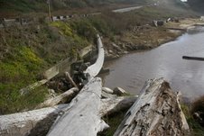
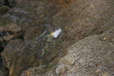
Pomponio Creek was running high and had formed a lagoon at its beach. While where the creek entered the ocean was easily fordable, I didn’t feel like clomping around in my rubber boots, so I used the “People’s Bridge” to cross it. This natural bridge, formed by a large tree trunk that spans the creek right below Highway 1, allows access to the southern portion of the beach without bushwhacking or wading.
If you’re allergic to poison oak or hate to get your feet wet it’s a handy, if slightly derring-do, method to reach the best flotsam-collecting area.
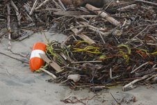
This particular day a crab pot buoy with its attached 150- foot rope heavily entangled in kelp was the only prize I found. The rope was the most tar-fouled one I’ve ever seen. The tar was substantially different from the tar balls that came ashore a few weeks ago. It was stickier and smelled different. I suspect it was the remnants of the heavy fuel oil from the Cosco Busan. That’s fine with me though, as that gives it more cachet when I use it in my still-growing “Battering Ram” artplay project. That’s the one composed of battered, oozing creosote, telephone or power poles, that I wrap in coils of the rope I recover and untangle. Enjoy. John
Posted inJohn Vonderlin|Comments Off on …..Between Storms……Story & Photos by John Vonderlin
After last Thursday’s moderate storm, and with a much bigger one predicted for Saturday, I used the narrow window between the wind and the rain to do a “sweep” of the usually heavily visited beaches from Pescadero north to San Gregorio.
The iffy weather minimized the usual number of beachgoers, and the high waters in the creeks splitting these beaches, left some areas isolated from the average flotsam-and-jetsam enthusiast. Which is why, this time, I chose to visit three, too-popular-for-one-like-me spots.
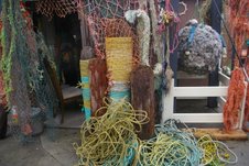
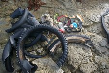
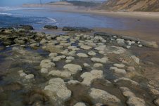
At Pescadero Beach I visited the minor, but highly specialized “Vomitorium” that occurs at the foot of the stairs leading to the beach from the parking lot directly across Highway 1 where Pescadero Rd. dead-ends. This Vomitorium is noted for its production of tires and tire parts, Aerobie rings, shoe soles, snorkeling gear and fishing line balls. It didn’t disappoint as you can see from this picture.
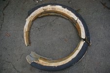
Note that the tire chunk on the right is the major missing part of the handmade Ford Model T tire by Star Rubber Company, which I’ve written about recently.
After three months “Neptune” has finally spit out the last major piece. Hopefully, the nice spoked wheel it was on will materialize next. Not too likely though, because while rubber submerged in the ocean is almost eternal, all metals are rapidly corroded.
A wooden steering wheel, riddled with wormholes, from an old Rumrunner’s jalopy, that the tire might have been part of, would be too much to ask for, I suppose. But, one can hope. Enjoy. John
Posted inJohn Vonderlin|Comments Off on ….Between Storms….Story by John Vonderlin
But, I do know “The Third Time is the Charm” aptly describes the effort. It was exciting, trying, scary at times, frequently beautiful, peppered with odd moments, and great discoveries.
Interestingly, after reaching my goal, the return trip was the most physically demanding. That was because I ended up caught in the dilemma featured in many stories and films, where the protagonist, having found the weighty treasure they had so fervently sought, often gold or heavy jewelry, must abandon it, in order to survive the ordeal of returning to civilization.
Only I wasn’t about to give up my hard earned treasure.
Here’s the story:
Last week I noticed that on the upcoming Presidents Day, there was going to be a nice 1.1 minus tide at about 3 in the afternoon. Perfect for my third serious effort to reach Acid Beach and Warm Water Lagoon.
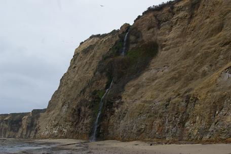
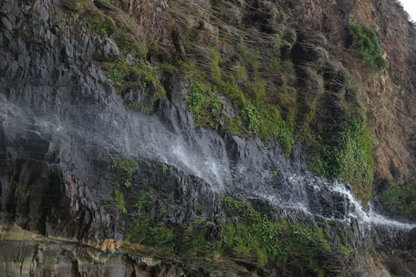
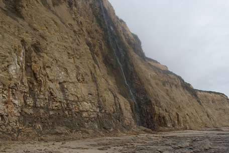
Parking at Scott Creek Beach, with the horde of other folks enjoying both the day off and the unusually mild February beach weather, we waded across the creek and headed north. Right away, thanks to the winter rains, we were treated to a series of picturesque ribbon-like waterfalls descending
the towering cliffs. For the first mile it was just a holiday stroll, until we got to the inlet that reaches into the foot of the cliff.
On our last outing, Meg decided not to get wet, and waited on the south side of the inlet as the potential 911 caller. When she saw that the winter waves had sucked two feet of sand out of the inlet, making it even deeper then before, she once again chose the sensible option.
I, on the other hand, tried to repeat my risky climb along the cliff-side, above the inlet.
But I’m afraid I was too sensitive about crunching the barnacles and mussel colonies underfoot, as I slowly retraced my previous path. Placing one foot in an open, but very slimy spot, I slipped and rather than be keelhauled by the mollusks as I slid down the cliff’s face, I launched myself into the mid-thigh-deep water, holding my camera high.
Moving fast before another wave surged into the channel, I pulled myself atop a rock that was only partially submerged, waited until the wave’s surge retreated, and quickly waded to where I could pull myself out of the water. Great!, my swimming trunks and the wetsuit booties I’d brought to use while wading around “Chicken’s Roost”*** were still safe and dry in my pack, but my clothes and boots were soaked.
Looking back, I saw Meg, wide-eyed from watching my lemminglike leap and flashed her a chagrin-laced grin, acknowledging my drowned rat appearance. Yelling, “I’ll be back in an hour,” I set off on my adventure
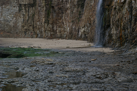
Ten minutes later, I watched as a sizeable group of sunning Harbor Seals, seeing me approach, began galumphing into the water from their sandy resting spot below a waterfall.
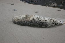
All except one that remained motionless on his back. I remember thinking, well, this is one dead marine mammal not even Ray Bandar, “the bone collector,” is going to be able to collect a skull from.
Walking up to the seal that wasn’t moving, I shot a picture, then noticed his little flippers waggling slightly. Believing the seal to be unwell, and not wanting to add any more misery in its final moments, I took one more photo and trudged on. Fifty yards further, I happened to glance back to see it steaming towards the water. The little feller must have been in a deep sleep, probably dreaming of somersaulting through the sun-streaked kelp beds, chasing some yummy fish, as I had approached and his buddies had fled without waking him. I guess they don’t get many visitors at this end of the beach.
Another five minutes, and I was at Chicken’s Roost, my own previous turnaround spot. Already soaked, I left my trunks and booties in my pack, stuffed my camera in, too, and began to wade around the face of the Roost.
Trouble greeted me immediately. The footing was uneven and large seaweed fronds obscured my vision of the bottom and made every move a slick and risky proposition. Two steps, and I almost went down, forcing me to grab the pockmarked cliff face. Unfortunately, the pockmarks were created by sea urchins, and more then a few were still home and apparently resented my visit.
Excusing myself with a curse, I edged along the cliff, looking for uninhabited pits to stick my fingers into. With my back to the surf, I didn’t see a big wave that smacked me into the cliff, its rebounding spray needling me in the face. Before my courage sank and drowned, I made it as far as a rock jutting slightly above the water, at the mouth of the slotted inlet just past Chicken’s Roost. This was the same slot I became familiar with on my first trip, I had been afraid I was going to fall in from the Roost’s top, ruining my camera, and maybe drowning after hitting my head. But not this time.
Having reached a secure spot, I took a moment to survey my situation and didn’t like what I saw. There, bobbing in the water in the slot, five feet in front of me, was a dead Harbor Seal. To my left, ‘round the next rock where I had planned on going, I could see the water was much deeper, the bottom invisible even in the relatively quiet times between waves. It looked like I was going to have to traverse the slot, push the corpse out of my way, and climb up a narrow, mussel-choked crack in the cliff. Oh joy. But. I’d come too far to turn back now.
I waited for a calm moment between waves and lowered myself back into the water. When my tiptoes still hadn’t touched bottom with my belt well under water, I knew I was beaten. I was at the edge of the wader’s equivalent of a sucker hole, guarded by a dead, floating portend. I pulled myself back up on the rock, and retreated the way I came. Defeated again!?
Reaching terra firma, I stood looking up at Chicken’s Roost, feeling checked if not checkmated. I took a deep breath and started to climb it.
Reaching the top, I crossed it and looked down at the steep scree slope that had sapped my courage on my first trip. It didn’t look inviting, but after what I’d already been through on this trip, the slope didn’t seem that fearsome. I was sure I could get down it, getting back up would have to be dealt with later. In desperation, I supposed I could always throw my pack with the camera up from the beach below, then, swim around. At this point even this shaky plan was enough when faced with the “Failure is not an Option” thoughts that were jabbing my ego in some of its most vulnerable areas.
I started lowering myself carefully down the treacherous slope. Seconds later I was standing triumphantly on solid ground, even though it felt like I was floating on air. There was nothing that could stop me now. And nothing did.
Except for the clusters of buoys I started encountering. The first cluster was below the rappelling spot where the Pranksters are reputed to have lowered themselves down to enjoy the inviolate privacy of this isolated beach (Acid Beach?) for their Bacchanalian psychedelic happenings. A nice mix of about a dozen floats, all within twenty feet of each other, were mine for the taking. I gathered them in a pile, promised I’d be back to collect them, and headed north.
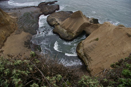
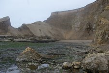
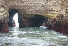
Soon I saw Warm Water Lagoon, its waters almost completely drained by the low tide, except for a large pool at the arches’ double-barreled opening into the lagoon and the narrow surge channel from the south.
Beneath the cliffs, on a ledge at the opening to the lagoon
was another cluster of floats and buoys. I stuffed my pack full, left it there and walked into this amazing feature: Warm Water Lagoon. On the right, and curving around in front of me, were sheer hundred foot cliffs. Seaward, on the left, a spine of sandy rock descended from the northern cliffs, reaching sea level where the surge channel at the south enters the lagoon’s mouth. The spine is only broken by two sea level tunnels through it that form an impressive double arch with a huge pillar of rock separating the two tunnels.
Waves were surging through the tunnels, spreading out in a beautifully symmetrical fan across the waters of the lagoon. To the best of my knowledge, there’s no more awe-inspiring scenery and no more beautiful arch, on the entire San Mateo Coastside—and it’s virtually unknown and less visited then the North Pole.
Yet on the beach, to the right of the arches, just exposed by the fully-ebbed tide was a seemingly new, ten- foot pole with a line-loaded reel, looking as if it just fallen from the rack in a sporting goods store. I picked it up and started my return.
Having left my pack at the opening, I soon stuffed my pullover’s pouch full with the smallest floats I found along the lagoon’s beach.
When my arms could no longer manage both the rod and reel and the larger floats I was also collecting, I started to thread them over the end of the pole. I marched southward carrying it like a banner pole for my expedition of one.
Reaching my backpack, I pulled out a huge bag I had brought and stuffed everything I was carrying into it and headed south.
As I marched along, I noticed a roomy ledge above me at the foot of one of the waterfalls. Curious, I stopped and climbed up to find another dozen floats, several varieties I hadn’t seen in many years. My pouch and hands full, I carefully climbed down and stuffed them into my bag, and resumed walking.
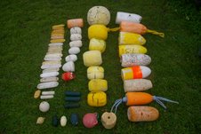
By the time I reached the rappel spot, I picked up another half-dozen floats that I missed earlier because I was intently focusing on my goal. Both my backpack and big bag were now bursting and I still had a dozen more in a pile on the ground before me that I had promised to rescue. A delightful dilemma for a float collector.
Searching around I found a length of seaweed, stripped it of its branches, and threaded five of the largest buoys in the bag on it. Stuffing the rest in the room created in the bag by removing the five, I was ready to move on.
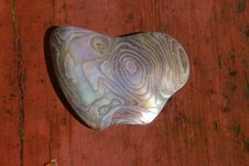
In one hand I carried the rod and reel and my buoy/seaweed necklace. My backpack was stuffed full of smaller floats, some shells and a handful of startlingly beautiful pieces of shimmering abalone
that I just couldn’t pass up, even though I don’t normally collect them. Over my shoulder, held in place by my other hand, was a gigantic bag stuffed with dozens of buoys and floats.
The only thing ruining my ecstatic state was worrying about whether I would make it through the upcoming obstacle course, especially up the Chicken’s Roost slope with my hands otherwise occupied, I wasn’t sure I could manage it all. I was carrying more floats and buoys that I’d ever collected from one place before. I didn’t want to leave anything behind, but what if I was forced to abandon my treasures, as so many others had in those books and films I’d mentioned? Nooooo!
By the time I’d reached the Chicken’s Roost slope, I was once again brimming with confidence. I’d simply strip some line off the reel, tie it to the buoys, climb to the top and drag them up one at a time, if necessary. But, nothing so time-consuming was necessary.
The first climb up I took the fishing pole in one hand, and used the other free hand to feel around for solid projections jutting from the scree. The rod and reel actually helped, as I wasn’t worried about damaging it. By jamming the rod and reel into the slope, it assisted me from slipping and sliding. Triumphantly reaching the top, I deposited my load, celebrated for a few seconds, and headed back down for the next two trips. The big bag was the most difficult because of its bulk and weight, but nothing was going to stop me now.
The remaining part of the return trip was a struggle that left me sore for a couple of days. But, even soaked, scratched, scraped and aching, I was not miserable. I was on a natural high. When I reached the inlet where I received my first dunking, now surging with the returning tide, I just jumped in and waded across with my camera held high, the fishing pole in my other hand. One more trip and I had the bag and seaweed necklace securely on the victorious side.
The last mile was a rest-punctuated trip, made easier by Meg’s assistance and the glow of accomplishment that buoyed my spirits. It doesn’t get better then this. That is until I return again for a much better photo shoot. And figure out a way to reach the other more isolated beach also captioned Acid Beach on California Coastal Records Project and the nearby sea arches-bookended oddity known as “The Notch.” (pictures #6418 and #6419 CCRP)
Until then I’ll just savor my treasures, shown laid out on my front lawn in this picture.
Or some of the jewelry quality pieces of abalone I collected. Enjoy. John Vonderlin
————
***I asked John, “What’s Chicken Roost?”
John:
Hi June,
Chicken’s Roost (my name for a nameless rock) is the spot I turned around at on my first attempt to reach Acid Beach in December. I think you published a picture of it in the story of that trip.
“Mrs. Nita Spangler, president of the S.M. County Historical Association, said that ‘she personally favored the preservation’ of the old Tunis School.
“‘It is my personal feeling that the Old Tunis School should be preserved because of the historical interest. The association has visited the place, and articles and pictures of it have been published. It is the only one-room schoolhouse in operation in San Mateo County,’ said Mrs. Spangler.
“It was pointed out that the ‘economics of preserving it are a matter of concern to the coastside’.
“An organization has been formed for the preservation of the old Tunis School. It consists of a group of people who”….[rest of the article is missing, doesn’t it bug you?]
To see a photo of the Tunis School, scan down to the post below.
Posted inTunitas Creek|Comments Off on 1960s: Historical Assn. Backs Preservation of Tiny Tunis School
From “Place Names of San Mateo County” by Dr. Alan K. Brown
Tunitas: The name has see occsional use in the last ninety or a hundred years as a designation for the ranching district at the lower end of Tunitas creek.
Tunitas Beach: (mouth of Tunitas creek) The older name of the placer is Potters beach, for the T.F. Potter ranch nearby in the 1860s and ’70s. Apparently the present name was first used when the Ocean Shore Railroad had a bus stop here, in the 1920s.
Tunitas Canyon: (Up Tunitas creek. This is one of the group of canyon names around Half Moon Bay. For the first twenty years, until around 1870, the Americans called it Tunitas gulch.
Tunitas Creek: “A small bush…grows super-abundant at and near its mouth, and its fruit is known to the present generation as sea apples.” The arroyo de las Tunitas (Beach-apples creek) is on two 1839 sketch maps. An alternative Spanish form without the diminutive, arroyo de las Tunas, appears in deeds of the 1850’s, was sometimes translated into Tunas creek, and survives misspelled in the Tunis School. (The misspelling is said to be due to the fact that when the school district was set up, in 1866, the clerk who drew up the papers was unsober.)
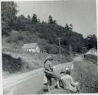
(Photo: Coastside artist Galen Wolf’s students sketching the scenes along Tunitas Creek Road. To the left, you’ll see the old, one-room Tunis School)
The East fork of the Tunitas (unlike most of the so-called forks on the maps has been so called for a hundred years. The upper portion was sometimes Harry’s gulch, for Henry Trebilcock, an Englishman who had an orchard there for forty years from the middle 1870’s. The Tunitas creek road was until recently still officially the Froment road: the Froment Mill interests built most of it in 1875, but ran out of funds in Smith Downing’s barnyard. The county opened the last half through to the coast in the early 1890s.
more to come
Posted inTunitas Creek|Comments Off on Funny name…What does Tunitas mean?……
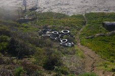
On Friday I returned to Tunitas Beach to do my version of a Nautilus workout, rescuing tires from the surf and lugging them around.
I added six to my pile at the bottom of the hill, making a total of twenty there, and upped my caches north of the creek to 17. As I was resting, sitting on the pile, a gentleman walked up carrying a tire that I had bypassed, that he’d somehow freed from its sandy prison near the surf-line to add to my pile, making the total 21, that most fortuitous of numbers.
We struck up a conversation during which he revealed he’d been cleaning up this beach for over twenty-five years. It seems that Tunitas Beach’s tires are a long- term phenomena. One that had previously been cleared up regularly by a nearby resident who would use a front loader to accomplish what I’ve been doing with sweat, persistence and clackety knees. Unfortunately, the loader broke down, as I probably will do one of these days.
He also dropped some interesting names of visitors to Tunitas at one time or another; the name Baba Ram Dass sticks in my memory. He also gave me leads to local oldtimer’s names that might have some interesting tales to tell about this most interesting of beaches. The gentleman is a very interesting oldtimer himself. George Cattermole is the longtime owner of the San Gregorio store, an avid environmentalist, and a prolific explorer of the beaches and hinterlands of the south coastside.
We’ve exchanged emails and I’m eager to drop by some Saturday when there’s usually music at his eclectic store/bar and share a beer and some stories. Hopefully more on that soon.
There were other items of note on this trip: I collected more tar balls to add to the crate I left by the tire pile. The previous ones, heated up by the warm temperatures of the last week, had melted and were trying to escape through the grating of the crate, but I thwarted them.
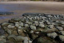
At the southern end of the beach, near Mussel Rock, the waves have removed more sand than I can remember, revealing a new group of concretions.
While not as attractive as the others I’ve photographed, and written about, they still were interesting and add one more facet to the buffet of oddity that very strange locale offers.
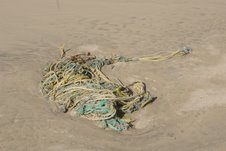
The 150- gallon gas tank I mentioned in an earlier post, possibly from the sunken “Good Guys,” was still there, so I photographed that too. As well as a massive tangle of ropes that was so heavy with wet sand I could only, with great effort, roll the ropes over and over, up the beach, beyond the waves for later recovery.
I’ll attach some photos. Enjoy. John
P.S. While this was a pleasant trip to the beach, more interesting then many, I’m impatient to hurry through my description of it so I can start describing yesterday’s adventure, one of the most enjoyable, exciting, trying, and productive trips I’ve ever made to the coast: My wild trip to Acid Beach. That’s coming next.
One of the recurrent themes of my essays has been the greatest claim to fame of the sleepy town of Pescadero.
Your book, “The Coburn Mystery,” detailed its most brilliant moments in the limelight during the 19th Century. Loren Coburn and the citizens of Pescadero’s battle for control of beach access to Pebble Beach, the most attractive rock collecting spot on the West Coast, as well as the mysterious murder of his wife placed it in the minds and on the lips of many in the Bay Area and even the state. But, as the century faded so did its notoriety.
A while ago, while rereading the “The Electric Kool Aid Acid Test” by Tom Wolfe, I came upon a single reference to Pescadero, and wondered if any other book or other medium had produced as many “eyeball” moments for Pescadero, as that one? This extremely popular book was published nearly forty years ago and has been reprinted repeatedly, including a leather-bound three volume edition as recent as 2003 that also includes “The Kandy-Kolored Tangerine-Flake Streamline Baby” and Radical Chic and Mau Mauing the Flak Catcher.”
The reference, which I thought might be Pescadero’s brightest lightning bolt of fame, is on Page 27 at the end of the first paragraph, at least in my paperback copy. This is the end of the graph where Tom Wolfe, is discussing with Ken Kesey, what was going on in his head when he returned to the United States, after hiding out in Mexico, to avoid a drug bust prosecution. Kesey, explaining what had happened there includes:
“-and I went outside and there was an electrical storm, and there was lightning everywhere and I pointed to the sky and lightning flashed and all of a sudden I had a second skin, of lightning, electricity, a suit of electricity, and I knew it was in us to be superheroes and that we could become superheroes or nothing.” He lowers his eyes, ” I couldn’t tell this to the newspapers. How could I? I wouldn’t be put me back in jail, I’d be put in Pescadero.”
When I read this, I laughed and thought, while Kesey may have seemed a little confused, perhaps it was a La Honda resident’s inside joke/neighboring town putdown.
After all, it’s hard to believe the guy that wrote, “One Flew Over the Cuckoo’s Nest,” which was set in a mental hospital, would confuse Atascadero State Hospital, with Pescadero. Whatever the cause, I think the old adage, “Say what you want about me, just spell my name right,” should apply.
I wondered if there were any contenders to this odd moment of glory for bucolic Pescadero?
Well, last night while watching the end of a movie I had seen a long time ago, I came upon a contender to the most viewed reference to the town of Pescadero, that completely blows away Kesey’s Freudian(?) slip.
It’a in a film that grossed $519,843,345 worldwide. A film that created a number of phrases that have entered our culture and endured for more then a decade. A sequel film that featured a character in the Top 100 (#48) heroes of film (American Film Institute) that had also been in the Top 100 (#22) villians of film (American Film Institute AFI) in the original, an unprecedented circumstance. A character, played by an actor, who, after an unprecedented recall election, became the governor of California. That actor being Arnold Schwarzenegger.
Oddly, it is once again the mutation of Atascadero State Hospital into Pescadero State Mental Hospital that creates this reference heard round-the-world. Here’s a summary excerpt from Wikipedia, about Terminator 2, Judgment Day, or T2 as it has popularly become known that explains the reference:
“Sarah’s experiences have significantly changed who she is, making her tougher and more vigilant, but also more desperate to warn humanity about the threat of the future human versus machine war — revelations that lead authorities to commit her to a mental institution, Pescadero State Hospital.”
My guess is, thanks to VHS tapes, DVDs, and worldwide distribution, more then half a billion people have heard this reference to the quiet, humble town of Pescadero.
I suspect the recent beginning of a television series entitled, “The Sarah Connor Chronicles,” is probably why the Terminator series is getting so many replays lately. I can just hear Arnie chuckling as he cashes his residuals checks saying so rightly, Hasta la Vista, baby. Enjoy. John Vonderlin
Posted inJohn Vonderlin, Pescadero|Comments Off on John Vonderlin Ponders Pescadero’s “Greatest Claim” to Fame….
In 1898 the steamship Colombia met its fate near Pigeon Point. But soon a new Colombia took its place on the international waters, commuting between Central America and San Francisco.
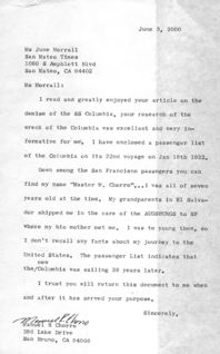
In the year 2000, I received a letter below from a passenger who was aboard the new Colombia.
The letter writer had read my historic piece about the Colombia and praised my work. Then he explained:
“I have enclosed a passenger list of the Colombia on its 22nd voyage on Jan 18th 1922.
“Down among the San Francisco passengers you can find my name ‘Master M. Chorro’…I was all of seven years old at the time. My grandparents in El Salvador shipped me in the care of the AUGSBERGS*** to SF where my bio mother met me. I was too young then, so I don’t recall any facts about my journey to the United States. The passenger list indicates that the new Colombia was sailing 26 years later.
Sincerely,
Manuel R. Chorro
San Bruno
———————–
I don’t know what “Augsbergs” means.
Posted inColombia, Manuel Chorro|Comments Off on Letter from a passenger aboard the ship Colombia in 1922
The rescue ships carried the injured, stunned and stricken survivors back to San Francisco where they were created at the emergency hospital.
Rumor had it that attorneys for the San Juan and the S.C.T. Dodd scurried among the shocked survivors, urging them to keep quiet and avoid reporter’s questions. Clearly the attorneys were less interested in the passenger’s welfare than the liability of the ship owners.
Despite painful abdominal and spinal injuries, Theodore Granstedt could not be dissuaded from talking, charging cowardice on the part of the San Juan’s crew.
“When the crash came, the entire crew deserted their posts and saved themselves. They made no effort to launch a boat or save a soul,” Granstedt said before nurses on the scene convinced him that he was seriously injured and needed to calm down and rest.
Theodore Granstedt had survived what the San Mateo Times called “the worst maritime tragedy the Pacific Coast had experienced in more than a quarter century.”
The Times noted that 72 people—most of them passengers, many women and children—met watery deaths as the Standard Oil tanker S.C.T. Dodd rammed the San Juan 12 miles off the San Mateo County coast.
The following day Sheriff James J. McGrath and his deputies patrolled the coastline. Hundreds of curious county residents lined the shore as Coast Guard cutters continued a futile search for more bodies.
As the facts were gathered, the tragic story emerged.
According to survivors on deck at the time, the San Juan was sheared almost in half by thee heavy stern of the tanker Dodd and sank beneath the sea before most of the passengers in their staterooms, and the crewmembers in their bunks, had an opportunity to realize the vessel had been mortally struck.
There were indications that a terrific hole had been torn in the side of the San Juan by the impact and she started sinking at once. When the swirling waters reached the engine room, there was a hissing of steam and then the boilers exploded—shattering the ship from stem to stern.
Most of those fortunate survivors were on the deck or in the saloon at the time of the disaster. Those below in their berths or bunks were doomed.
“It was not a matter of four or five minutes before the ship sank,” Charles J. Tulee, the San Juan’s First Mate said. “It was a matter of only a few seconds.”
The second mate backed up Tulee’s version, adding that the vessel sank as he attempted to help some women and children into one of the lifeboats. That lifeboat was the only one that might have been launched—but it was shattered in the boiler explosion, hurling the women into the air, injuring many seriously. Only a few survived.
Until the results of an official investigation there was the usual finger pointing. The owners of the San Juan blamed the tanker Todd, listing the heavy blanket of fog that covered the Pacific at the time as a contributing factor.
Just as insistent was the Dodd’s Captain Bluemchen, who reported that in spite of the fog, the San Juan’s lights were visible, and that she suddenly changed her course, cutting across the Dodd’s pathway.
As Captain Asplund had perished in the disaster, the authorities would never know his version of the events.
Some critics opined that the San Juan was too old to go to sea, but others commented that the steamer’s hull had been inspected by officials and pronounced seaworthy.
Captain Frank Turner, a federal steamship inspector, added that the Titantic was a new ship but she sank almost immediately upon receiving a blow comparable to the one suffered by the San Juan.
The bickering and accusations continued until the official inquiry, including a trial, was completed.
According to reports, the U.S. Steamboat Inspection Service Board found the San Juan inshore of the Dodd, tried to cross the oil tanker’s bow, was rammed and sank within a few minutes on August 29, 1929.
In other words, responsibility for the San Juan disaster was placed squarely on the shoulders of Captain Asplund. This decision did little to mitigate the suffering and loss of life.
The sinking of the San Juan remains one of the worst maritime tragedies that ever occurred off the San Mateo County coastline.
(The End)
Posted inSan Juan|Comments Off on Summer 1929: Tragedy at Sea Near Pigeon Point Lighthouse, Part III