
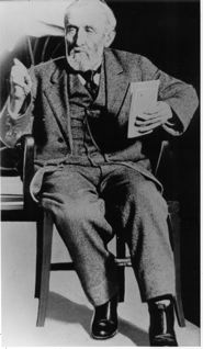
(Pescadero’s litigious Loren Coburn testifying in court.)

(Sarah Coburn, Loren’s second wife and the sister of his first wife. Sarah was murdered in Pescadero in 1919.)
(Pescadero’s litigious Loren Coburn testifying in court.)
(Sarah Coburn, Loren’s second wife and the sister of his first wife. Sarah was murdered in Pescadero in 1919.)
Story by John Vonderlin (email John [email protected])
Hi June,
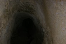
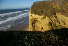
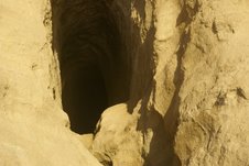
I had a chance yesterday to explore the tunnel in the cliffside near Pescadero Beach. I’m convinced the tunnel was part of the coastal defenses, hurriedly constructed after the Japanese attack on Pearl Harbor. I’m hoping to get confirmation of this soon from local authorities.
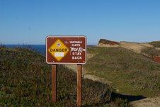
Parking off Highway 1, in the tunnel’s vicinity, I decided to retrace the path I had used before, on my first visit, as it had been a much easier trek then the horrendous cross-country, bushwhacking trip to it.
Unfortunately, while heading in this direction, I saw the front of the sign I hadn’t read when I exhaustedly passed it while escaping out of the canyon that first time. It forcefully urged me to STAY BACK. UNSTABLE CLIFFS.
The well-trodden path to the cliff’s edge let me know that a number of scofflaws had not taken this sign seriously. I assume there is no law violation involved, but I’d urge other adventurers not to follow this path, as the cliffs are very unstable here, especially with the winter’s rain.
Having been startled more then once while walking local beaches as large chunks of cliffside crashed onto the sand beside me for no apparent reason, I did take the warning seriously.
Moving parallel to the sign, I found a small animal trail that eventually joined the faint trail descending into the canyon further on, but a safe distance from the cliff’s edge.
The faint trail peters out at the edge of the steepest slope near the bottom of the canyon, but if you’re determined and confident, it is not too hard to find a fairly safe path to the gully’s floor. Following the gully seaward, I arrived at the sheer 40- foot cliff that drops to the rocks on the beach below.
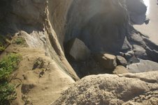
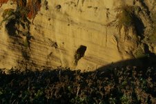
From there I could see the tunnel opening, above me, on the north side of the cliff as it turns eastward into the gully.
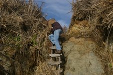
I had to be extremely careful; it’s very muddy and slick there. As I tried to climb towards the opening, I recalled slipping and sliding on my first trip, ending up soaked thigh high, sunken up to my knees in slimy mud.
I had to find another way to enter the tunnel and a ladder was not going to help. There was only an eight- foot drop from the tunnel opening’s floor, but it led to a narrow, water-filled pool with unclimbable walls, left and right.
There was no place to rest a ladder at the face of the cliff. Even the mud at my side of the pool’s depression was so squishy that my shoe almost vanished into the ooze without my putting any weight on my foot. I was stumped.
It was then I remembered something I had seen while channel surfing the night before. I stayed online long enough to watch a show called “Ninja Warrior,” where contestants competed in a series of timed Challenges involving the navigation of obstacle courses.
One difficult “challenge” involved inching along between a pair of four-foot-apart parallel Plexiglas walls for about 40 feet, keeping themselves from falling into the cold water below. The contestants accomplished this by exerting outward pressure on the Plexiglas with their hands and toes. But the slippery walls, coupled with physical exhaustion, tossed several challengers into the drink.
I thought I might apply a similar technique, and come up with a better result.
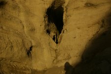
Climbing to a spot on a sloped ledge to the left of the tunnel opening, I slowly inched towards it until the slope was too steep to risk any further movement. Then, gathering all my courage, with arms extended, I toppled over, heading for the cliff on the other side of the pool. The extreme physical moves sent a shock through my shoulders, but it worked. At least it worked for the moment.
But there was no going back now; I could only press onward or fall downward into the pool. Nearly horizontal, with hands and feet pressing firmly against the opposite sides of the narrow slot canyon, I was suspended seven feet above the pool. Moving my hands and feet alternately, I began a clumsy sideways shuffle towards the opening.
Fortunately, my friend Meg didn’t want to approach the slick muddy parapet below the opening, just above the 40- foot drop to the beach, so she couldn’t photograph the fear rippling across my face. I didn’t think I’d be seriously hurt, but my camera and pride might not have survived a fall into the quagmire below and I’m certain it showed.
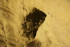
Reaching the tunnel’s opening, I was able to rest on the sloped remnants of the rock floor that hadn’t been eroded by the water flowing through it. Holding my small LED flashlight in my mouth, I continued to move deeper into the cave’s darkness until I could finally drop to a solid-looking part of the muddy stream bottom, worn six feet down from the tunnel’s original floor. Walking further in, I came to a sheer, seven- foot cliff that someone had cut shallow handholds into. Using my flashlight I could see there was a short side tunnel above me that may or may not have had another branch off it. But, around the corner to the right, I didn’t need my flashlight to see the light at the end of the tunnel. There was a second opening, partially covered with brush, about a 100-feet ahead.
I tried to scale the cliff using the handholds, but was unsuccessful. Likewise, the branch leading to the opening was unclimbable. Satisfied, I shot a few pictures and headed back towards sunlight. I was able to retrace my steps successfully, and soon was blinking in the bright sunlight with a big grin on my face.
Having related to Meg what I found, we decided to check out the other end of the tunnel to see what we could find. Heading upstream, we quickly realized as we stood in the wet, spongy, heavily overgrown bottom of the gully, that it was going to be very difficult. Instead, we climbed back up to the road and headed north on Highway 1.
Unable to see the tunnel’s opening in the tangle of growth below us, we each took our guess at the best route and started battling downward. I made a bad choice and was soon in over my head, caught in a thick tangle of spiny vines and heavy underbrush that looked suspiciously like poison oak without its leaves.
Turning tail, I struggled back to the road, from where I could just see the top of Meg’s head in the brush below. I decided that since I knew about how long the tunnel was, it might be easier to go across the northern rim of the canyon to the approximate spot above where I thought the opening was and then head straight down.
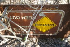
That worked fairly well, except that when I reached the gully’s bottom, the opening was nowhere in sight. Heading upstream, bulldozing the thickets of small rotted trees that blocked my way, I headed towards the direction of Meg’s voice. Shortly, I stumbled on the topsy- turvy sign shouting KEEP OUT! STRUCTURES AND GROUNDS UNSAFE.
I felt sure I was close, and that my surmisal that this tunnel had been an observation post was correct.
Thirty feet away, down a steep bank I was able to shout: “I see it!,” just as Meg burst free from the thicket of bushes above me. I entered the cave and gingerly straddled the eroded gap in the floor to just above where I had turned back when I entered it from the other end. Mission accomplished.
Returning to the upper opening, I noticed there was part of a concrete footing that probably had supported a door to seal it way back when it had been used. After all, they wouldn’t have wanted “frogmen teams” to sneak up on them and slit their throats before they could sound the alarm.
My belief is that some time after WWII, just as with the “tsunami Prankster cave,” I’ve written about, this cave was considered a public nuisance. Officials posted a sign warning people to stay out, and forgot about it. Because of its virtual invisibility, they probably felt plugging it wasn’t necessary. I saw absolutely no sign that anyone had visited this spot in many years. In fact, I can’t imagine there are many people that would bother.
Nevertheless, I’m very happy I did. The entire expedition helped me to visualize what those frightening times after Pearl Harbor must have been like. America, reeling from the blow, was frightened it would happen again and reacted with both vigor and panic. The string of coastal defenses and the brave people who manned them, were an important feature of that critical time.
Peering endlessly at the mighty Pacific from a small tunnel’s opening in a difficult-to-get-to Cliffside, US soldiers hoped to see, yet prayed they wouldn’t, waves of Japanese bombers headed for the Bay Area, enduring this lonely, isolated spot, miles from civilization, believing they were making the public feel safer. They are probably all dead now, but I thank those sturdy men of the “Greatest Generation,” who gave up so much. Enjoy. John Vonderlin
[Note: I wrote this in 1977]
As spokesman for a circle of prominent South Coast residents, Dr. Isaac Goodspeed faced the press in 1868 and flatly denied accusations that local citizens planned to resist efforts to sever Pescadero from Santa Cruz County.
He had the petition to prove it–including an impressive list of taxpayers ready to unite Pescadero with San Mateo County.
All the signers said the same thing: The only road leading to the county seat in Santa Cruz, 40 miles south, was impassable most of the year. That meant the Pescaderans had to travel and extra 90 miles, via San Mateo and San Jose to reach Santa Cruz.
Hopes were not raised by talk of improving the closer route. Even a master engineer, the Pescaderans said, could not build a road through the Waddell bluffs at the ocean’s edge. The bluffs formed a natural, impenetrable barrier between Pescadero and Santa Cruz.
Pulling out of Santa Cruz and joining San Mateo County appealed to everyone. Redwood City was a mere 20 miles away and stages headed over the mountains daily.
The so-called “Boundary Bill” sailed through the state legislature with little opposition in 1868. The County of San Mateo welcome its new taxpaying citizens and surveyors added 90,000 acres to official maps.
Hi June,
A return trip to the tunnel is on hold. But here’s a few more pictures of it. The mud below the entrance is extremely slick because of the small rivulet that flows along the now eroded floor. I’ve got all my equipment together for an attempt. I just need some good weather. It looks like a fun way to end the year during the day on New Year’s Eve. Enjoy. John
Email John ([email protected])
Story by John Vonderlin (email John: [email protected]
Hi June,
Knowing a picture can be worth a thousand words you might want to include the picture numbers from the California Coastal Records Project (CCRP), that cover the Lou Denny Wayne shipwreck area.
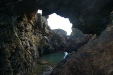
The promontory with the pass-through sea cave with the unusual sealife inside it, is shown at the extreme lower left in Picture #6331. You can see the difficulty of passing by this area without a very low tide.
The next picture to the northwest #6330, with a large wave crashing on the promontory that the semi-submerged cave cuts through, illustrates the caution necessary and danger posed to anyone that tries to go this way. In the lower left hand corner of that same picture is the site of the Lou Denny Wayne‘s grounding.
With the only way off that beach being to climb the cliffs in the dark of night, my hat comes off to the captain’s son who accomplished that.
Finally, if you look carefully at the large file of Picture #6327 , you can see the top of the arch I mentioned. It’s part of the promontory about 2/3 of the way from the left of the picture. The arch is just to the left of the fountain of spray from the wave crashing into the promontory. Picture #200401039, which is of the same area, just two years later, shows the arch a little more clearly in the large file.
A WARNING: I urge anyone attempting to follow our path to be extremely careful. You might find yourself between a rock and a hard place and nobody is going to hear your scream for help. Enjoy. John
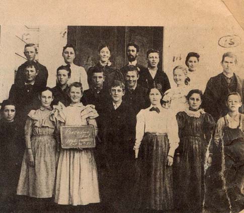
The class occupied one room in the local school building and it is said that students who failed to study were not allowed to attend.
Story by John Vonderlin (email John: [email protected])
Hi June,
As you detailed in your book Half Moon Bay Memories, Pigeon Point’s history has been punctuated by a series of disastrous shipwrecks. The grounding, the night of November 28th, and subsequent destruction a few days later of the classic wooden boat, the “Lou Denny Wayne,” is just the latest addition to that long list of tragedies.
As I related in an earlier email, while collecting marine debris north of Ano Nuevo point early in December, I found a pair of expensive, sand-clogged Henri Lloyd bibs. When the owner of the Lou Denny Wayne, identified them as his, I promised to drop them off the next time I swung through Santa Cruz. Between that oddity and having read the newspaper accounts of the mysterious accident two miles offhore that hulled the boat, resulting in the desperate decision to try to run it aground on the nearby rocky coast, my curiosity was piqued: Where had it gone aground and what was left?
The newspaper described it as one mile south of Pigeon Point Lighthouse, and even had a good picture of the boat taken from the cliff above. But, extrapolating from the rocks pictured in the online newspaper photo to the series of California Coastal Records Project (CCRP) photos of that part of the coast proved difficult.
The shore is so rocky there that even a small variation of tide can change the exposed rocks’ appearance or submerge them entirely. However, I did tentatively identify a spot I thought was probably the site.
It just so happens this two mile stretch of beach, from Pigeon Point south to Gazos Creek, is one of my favorite float-collecting areas. It’s isolated, lined with difficult to climb cliffs, whose tops are covered by no-tresspassing farm fields. Much of it is virtually inaccessible except during a very low tide, and it has numerous promontories splitting the coast into a series of hidden pocket coves. All of those factors conspire to limit my competition and keep whatever floats ashore there for me to collect. Though even, I, “the Intrepid Traveler,” had never made it the full length.
To the south from Gazos Creek, a steep cliff, holed by the pass-through sea cave that has the best sea life
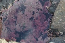
in it of any one I know of on this coast, had always stopped me. And from the north another steep-faced promontory, ending in deep water, had always left about three quarters of a mile unexplored in the middle stretch.
Well, I decided to introduce my curiosity to the extremely low tide on Saturday and go on a adventure.
Parking at the last place legally accessible south of Pigeon Point, we hiked through the brush in a small canyon, then climbed down the hidden ladder
somebody put there a few years ago and headed south. We weren’t expecting to find many floats, as the North Pacific SubTropical gyre has not been disturbed for almost two years by the consistent Westerlies necessary to bring its treasures ashore, And even the buoys from local crabbers have been greatly reduced in number, thanks to the late season start caused by the oil spill. Hmm. I wonder if I could file a claim too?
We weren’t expecting to find the great number of abalone shells that had been driven ashore by the same giant waves that destroyed the Lou Denny Wayne, killed two crabbers out of HMB, and a veteran big wave surfer at Ghost Trees. Unfortunately, I’ve given up collecting shells, feeling they’re too common and not useful for my art.
After about an hour of walking along short pocket beaches, then clambering around the promontories defining them, on wet, algae-slicked rocks, we reached the spot where I thought the Lou Denny Wayne had gone aground.
Absolutely nothing was left. Sigh. Except, to turn around and retrace our hazardous route. But, it was too easy to imagine the possibility of a broken ankle or wrist from a fall given our tiredness taking that route. Besides this was virgin territory and maybe I had been wrong about its watery grave’s location. The possibility of finding somewhere to climb the cliff and dash across the farmer’s field seemed reasonable, so we continued south.
Soon we were totally surprised to come upon this beautiful arch. Surprised, because I’d looked at every one of the large file pictures for this area on CCRP and hadn’t seen any arches at all, let alone this beauty.
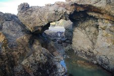
The promontory, whose gap the arch spanned, projected into deep water, necessitating passing under it to go any further south. Fortunately, the rocks above the pool under the arch provided good footing and it was easily accomplished.
Story by John Vonderlin (email John: [email protected])
Hi June,
Part I: I’m Tired
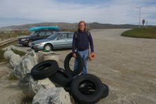
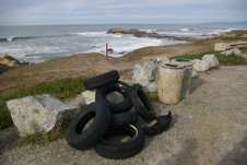
Yesterday’s expedition was quite amazing. The first important event occurred at Pescadero Beach when I added pictures of six more tires coughed up from the ocean to my “101 Tires” artplay project, or: “I’m So Tired,” as I sometimes refer to it.
While I’m sure the poor sanitation worker who has to load them onto his truck will be irritated– along with his private contractor boss, whose profit margin is wounded by the $7 a tire dump fee he must pay– I was quite excited by reaching another significant number.
Last time it was 5 tires bringing the total to 51, just edging past the halfway mark, in any endeavor a memorable point. This time, in one fell swoop. I reached 57, a much more powerful number.
Part II: Meanings Behind The Number 57
By the way, if you’ve ever wondered where the expression, “one fell swoop,” originated, it’s apparently one of the myriad things ole Bill Shakespeare contributed to our language. Shakespeare is first recorded as using it, in Macbeth.
When Macduff hears that his family has been murdered, he says in disbelief:
All my pretty ones?
Did you say all? O hell-kite! All?
What, all my pretty chickens and their dam
At one fell swoop?
The collective image that Shakespeare’s audience would have brought to mind was a falcon plummeting out of the sky to snatch its prey (a kite was a bird of prey before it became a paper and wooden toy.)
…more coming…
The Cemetery in the Sand Dunes
In the summer of 2001 something white in the sand caught the eye of a hiker as he walked among the wind-eroded dunes near Point Ano Nuevo. There was something about it that made him start digging.
He quickly uncovered a shocking discovery that made him think violence had happened here: Murder.
For there, only inches beneath the sand in front of him, he later told the San Mateo County Sheriff’s Department, there was a skull.
Actually, the sheriff’s investigation would find there were many skulls there and many leg and arm and back and rib bones. Dozens of them. Enough to fill a cemetery.
And indeed, that’s what the hiker had found, a cemetery lost for decades among the shifting sand dunes.
While wrong about this being a murder scene, the hiker was right in surmising that these unfortunates had died violently and the clue was in the roaring of the surf that pounded the nearby beaches.
The sound of the surf is probably the last thing these poor souls heard and is precisely why most of them died.
These dead people had once strode the decks of sailing ships such as the “Sir John Franklin”, the “Coya” and the “Hellespont”.
All perished in the 1860s when their ships, blinded by the heavy fog, struck reefs between Pigeon Point and Ano Nuevo and sunk wuth heavy losses of life. The dead were buried side-by-side in a dunes area originally fenced off and marked with headstones.
The remains of ship’s officials were generally not found at these sites as relatives often claimed them for burial in family plots.
Overtime the strong winds disturbed the sand dune environment, exposing the cemetery site. the shipwreck victims had been buried in redwood coffins–but even this superior wood could not withstand the effect of the sometimes brutal weather and the coffins are now the consistency of wet cardboard.
When I last worked on this story, park rangers were working to stabilize this historical shipwreck gravesite so not to disturb the human remains. A pedestrian boardwalk was to be built with interpretive signs enabling the visitor to learn about the cemetery (and at the same time they will be advised of the laws against disturbing archaeological remains).
(Photo: Raymond Watson)
