100 Years Ago Pescadero Stage Calls it Quits: Replaced by Motor-driven Vehicle

Images/Story from John Vonderlin

Email John ([email protected])

24

HE SAN FRANCISCO CALL

October 12, 1909
THE INSIDER
Tells of the Passing of the Historic Stage Line Between San Mateo and Pescadero, Which Was Made Unprofitable by Railroad Competition After Less Then Fifty Years Operation
Motor Cars Replace Six Horse Coaches
Scant notice, if any, was given by the San Francisco press of the passing of one of the historic stage lines in this state. A few weeks ago all the coaches and livestock of the stage line plying between San Mateo and Pescadero, via Halfmoon bay (sic), Purisima, and San Gregoria, (sic) were sold at auction. For a little less then a half a century the line had been in existence, but the advent of the Ocean Shore railway introduced a competition that could not be met, and so, like the other stage lines, it passed into history.
Before Del Monte was thought of, and Santa Cruz was dreaming of its future, Pescadero, with its famous pebble beach, was one of the most popular seaside resorts in the state. Every morning in the summer the big Concord coach with its six well groomed horses left San Mateo for Pescadero, loaded to capacity. Often there were two or three coaches. The route was through the Crystal Springs Canyon, across the Canada de la Raymunda, up the mountain and down to Halfmoon bay, (sic) and thence along the coast to Pescadero. A more beautiful ride can not be found in the state.
The elder Swanton, whose son Fred is now the big gun at Santa Cruz, ran the hotel at Pescadero and his fame as a caterer was established by the bon vivants of the San Francisco clubs.
Not a few of the drivers who piloted the big coaches had seen service on the great overland stage lines and when the locomotives put them out of business they drifted to the coast line, where the war whoop of the redskin was never heard and the road agent made no profit.
The rumble of the road coach is stilled, and in its place is heard the whirr and whiz of the motor driven vehicle.
—————-
I wonder what would have been the response of the newly unemployed stage drivers if I could have nursed a few beers with them at the Swanton and told them of the things to come and go along the Coastside in the next hundred years? Enjoy. John

83

Posted in Uncategorized | Comments Off on 100 Years Ago Pescadero Stage Calls it Quits: Replaced by Motor-driven Vehicle

Explorer John Vonderlin tracks the route of the Ocean Shore RR

111

Ocean Shore Route
Story/Photos by John Vonderlin
Email John ([email protected])
Hi June,
Ever since I ran into that article in the Newspaper Archive about the 16,000 pounds of explosives being set off north of San Gregorio to aid in the creation of the Ocean Shore Railroad’s route, I’ve been thinking more and more about the railroad’s proposed route. I haven’t yet tried to find the 65,000 cubic yard displacement that the mighty blast caused, but I did run into an interesting document that is related: It concerns the  railroad’s projected route, at least at some point in time, across Pescadero Creek.
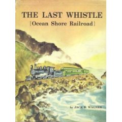
I had theorized about this part of the railroad’s route in a posting concerning the tunnel (quite possibly originally built to store explosives) that used to exist in the side of the hill just above the northernmost parking lot of Pescadero State Beach Park. Based on the length of the planned trestle for Pescadero Creek which I found in a document in Jack Wagner’s out-of-print book, “The Last Whistle,”  a6d9a2c008a0ab126f083010_aa240_l as well as the knowledge that Highway 1 now follows much of the railroad’s planned route, I assumed the Ocean Shore would have taken a straight shot down the hill, across the dunes, and over the creek bed to the solidity of the promontory to the south.
My theory was bolstered by examining the 1972 photos on the California Coastal Records Project website (CCRP). They show the dune-covered peninsula “the gunbarrel-straight route” would have followed, significantly wider even as recent as then, thanks to the much more generous amount of sand that existed to the west. Straight as a rail is almost always best in the transportation business world.
Well, it looks like I might be wrong. It’s not a certainty, as the “dotted line”
routes of  railroad-building dreamers were very flexible even before they met the realities of construction.  But, based on the aforementioned 1960’s document, it would seem the railroad’s late 19th/early 20th century planners tried to avoid as much of the sandy stretch as possible by bowing to the east, following the lower contour of the hill and then a promontory jutting out from it, until returning to the dune area, where a raised trestle started and continued until it had crossed the creek. I’m guessing with well-driven pilings, the problem of blowing sand drifting on the rail-bed, as well as flooding from the creek, either during storms or when a sandbar across the creek’s mouth created a large lagoon,  all would have been dealt with nicely.
I’ve attached a shot of the railroad’s document showing the bow in the line with

95

added black boxes to help see the route. I’ve also attached a Screengrab from a recent CCRP picture (Picture #200809967) that focuses on the area at the point

102

the route returns to the dunes, crossing over one short swampy stretch.
One of these days I’ll try hiking around “North Pond,” as the area encompassed by the route’s bow is called, to see if there are any signs of the railroad’s rail-bed left, other then the faint ledge, that up to now I had thought was only big enough for a jeep or possibly a long ago stage road.
My last visit there was the nearly disastrous, and ultimately unsuccessful attempt, I made to attempt to remove two car tires that had irritatingly been scarring the limited beauty of the North Pond’s mudflats for more then a year. This time I’ll try to verify whether this “new” route was ever graded and hopefully not start the New Year as a stick-in-the-mud theorist. Enjoy. John
Posted in John Vonderlin, Ocean Shore Railroad | Tagged | Comments Off on Explorer John Vonderlin tracks the route of the Ocean Shore RR

John VonderlIn: Huge New Clues in the “Mystery of Monty Parker/Message in a Bottle” Story

johnvJohn Vonderlin’s earlier posts about Monty Parker, please click here

Email John ([email protected])

Read the emails between South Coast explorers Larry Fitterer and John Vonderlin
mp1

Hi John,

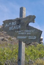
I took my twins to the coast yesterday afternoon.  We hiked down to Greyhound Rock and explored the surrounding tide pools.  On the way back, I noticed a truck in the small turnout directly above the Monty Parker sign.  We hiked down to the sign and found two ropes going over the edge.  Off in the distance, toward Warm Water Lagoon, we saw two men and a dog building a fire.

I remembered the jar you left at the base of the sign and checked it.  Someone left a note!  I did not take the note, since the spot feels like a shrine, and I don’t have the contents committed to memory.

Here’s what I recall.  Monty Parker was a long time resident of the area, an avid explorer, and abalone diver who drowned just off that spot while diving for abalone.  He was a high school sports coach, and there is a sports field (Parker Field) named after him.  The school name was abbreviated, and I don’t recall the initials.

I was sure the gentlemen down below were acquainted with Monty Parker, and I wanted to wait for them to ascend the rope.  However, it was getting late and the kids were getting antsy.  Instead, I left my business card on the windshield of the truck and invited them to call me to discuss Monty.

Several hours later, I received a call on my mobile phone.  No message, but I’m pretty sure it was one of the climbers.  I called back and left a message.  I will let you know if/when I connect with them.  Hopefully, they can unravel the Monty Parker mystery.  Also, I would love to know how they got their dog down the cliff!

Hope all is well, and my best to Meg,
Larry

—————-

mp1

Hi Larry,
Great to hear from you. I think you are more then halfway to solving the mystery. Monty having drowned at that beautiful spot is sad, but he was doing what he loved at his favorite place in the world. I should be so lucky(in a couple of decades). It certainly explains how somebody in good enough shape to rappel down the cliff would die so young. I’ve been websearching various combinations of terms from the info you provided, but no hits yet.
It’s great your kids are already accompanying you on some of your adventures. They’re only seven, right? With any luck in ten years they’ll be teasing you about keeping up.
Like you, we also used the tremendous lowtide to check out some of the coast on Friday. We were able to climb out on the far end of Pillar Point from the northside, out to just landward from the Maverick’s surf spot. I haven’t found any Internet mention of anybody else doing it yet, but it seems so much tamer then our previous trips to Acid Beach or The Notch, I’m sure somebody must have. It does take a great low tide though. In a nice bit of synchronicity we discovered a very photogenic walk-through arch that is invisible on all the CCRP photos and also is not mentioned anywhere on the web.. Takes the sting out of knowing where WALDO isn’t.  I’m writing a story about it that’s almost done.
Pillar Point was actually my second choice, but the fairly large-sized waves on that day made a second try at probing north from Gordon’s Chute a bit wild. June just posted the story about our first try. Why don’t you check it out and see if it’s something you might want to try someday. Apparently, it would take a combination of the lowest tide and calmest waves to make it possible to walk and wade through part of it. But, using a boogie board and fins it seems quite possible. It is a spectacular stretch of coast with an amazing number of sea caves.
Next trip to Amb’s, I’ll photograph the note and leave another one thanking whoever left it.

Thanks again for following through. Meg and I wish you and your family the happiest of Holidays and hope to see soon. Enjoy. John

Posted in John Vonderlin, Larry Fitterer, Monty Parker | Comments Off on John VonderlIn: Huge New Clues in the “Mystery of Monty Parker/Message in a Bottle” Story

Blink + you’ll miss “Gordon’s Chute” Shoot

Hi June,

While picking my way through the slimy, lowtide-revealed path to the Gordon’s Chute site, the frequent explosion of whitewater, above the base rock that once served as its wave-washed foundation, warned me of the problems we would face.

52

Once we had climbed onto the base rock, and I had a chance to view the circumstances present at the lowspot I had planned to climb down at, I knew I’d reached another Chicken’s Roost in my coastal explorations. I could look at the virgin territory to the north below the sheer Tunitas cliffs, but I was loathe to risk my life by actually penetrating, “The Forbidding Zone.”

22

As you can see, my hope that I could ease myself down through the slippery lowspot between waves and splash my way at least to the sea cave was not to be. At least not that day. Instead I did a photo shoot from various points on the base rock, trying to capture what it must have been like for the hardy seamen a couple of centuries ago who anchored their boats offshore and loaded them with products from local farmers by means of Gordon’s amazing structure. Here’s an excerpt I found in the Newspaper Archives (cbsr.tabbec.com) as to what those products might have been.

The sole reference I could find to this short-lived, but ingenious structure was in the September 14th, 1876 issue of “The Daily Alta.” In it’s regular “Importations” column, was listed “GORDON’S CHUTE – Per Continental ( where it was coming from and the ship that was bringing it to S.F.) 745 sks barley, 342 do oats, 172 do beans, 1552 do potatoes. (sks is sacks I suppose, “do” I’m not sure about, surely a volume or weight measurement.)

This amounts to almost 3,000 units of produce that had to be “slid” down the one- hundred- foot- high chute to the cargo loaders waiting below, on a ship. that because of the waves. is rising and falling, rocking back and forth, as well as rhythmically surging against its anchors. Something that apparently was fairly dangerous and susceptible to mishaps.

This picture from the end of the base rock with exploding surf topping it conveys some of the ocean’s danger. Though the speed and weight of the various “sks” or “dos” coming down the chute was a constant danger, irrespective of the ocean’s conditions.

82

349336

taken from the very end taken between big sets that demonstrates what the sailors would have been looking at landward, minus the Chute of course. I imagine when a strong storm eventually wrecked the chute, there were more then a few sailors that rejoiced at its demise, had a strong drink or two and recounted to their wide-eyed mates what it was like during some of their wilder runs to Gordon’s Chute. Enjoy. John

Posted in Gordon's Chute, John Vonderlin | Comments Off on Blink + you’ll miss “Gordon’s Chute” Shoot

Tafoni.com for Everyone!!! Story/Photos by John Vonderlin

Tafoni: Miniature Natural Wonders
Story/Photos by John Vonderlin
Email John ([email protected])
Hi June,

In a recent posting I referred to the new website, Tafoni.com, which is dedicated to the minor natural wonders, tafoni, for which the Coastside is ground zero. Although, tafoni are found all over the world, from the Alps to the Sahara Desert, we have the greatest concentration, and in my opinion the most interesting types right here along our Coastside.

While exploring the site, I noticed a type of tafoni new to me, and so odd that I felt I had to investigate and find some to photograph myself. This new-to-me type is called “boxed tafoni” or “tafoni with boxworks.” On the “Enter” page of Tafoni.com you can see an example if you look in the middle, towards the top of the largest picture. You’ll see what looks like rectangular, nested boxes seen from the top. If you check out the Northern California section in the Gallery at the site, you’ll see three examples of these oddities.

After the disappointment of finding the crumbled remnants of WALDO, the Sea Arch, we drove to Bean Hollow Beach parking lot and headed south along the Arroyo de Frijoles Beach. There is a small, lightly used trail up the steep hill and into the forest of tafoni festooning the ocean side of the cove’s southern promontory.

With a new appreciation of these little oddities fine-tuning my perception, I started seeing all sorts of wonderful variations of them. I was clicking my camera almost every few feet, when I was startled to see two wonderful examples of “boxed tafon”i right in front of me. Here’s what they look like in close-up. I’ll salute anyone who can clearly explain the mysterious forces that produce such an illogical, unnatural-appearing erosional feature.

If you’d like to see these tafonis, and their amazing neighbors, check out the surrounding area at Picture #200810017 on CCRP. The best concentration of the tafonis are just above the surf, directly down the page from where Highway 1 disappears behind a hill. Enjoy. John

Posted in Uncategorized | Comments Off on Tafoni.com for Everyone!!! Story/Photos by John Vonderlin

Minus Tide: What Happened to My Best Arch (MBA)? Story by John Vonderlin

More photos coming soon
The Fallen Arch
Story/Photos by John Vonderlin
Email John ([email protected])
Hi June,
Today’s trip to the Coastside was perfect, in concert with its delightful low 60s temperatures, its sunny blue sky, its almost windless and tourist-less vistas, and the revitalization one feels when viewing the coastal hills greening up from the earlier rains. Even my camera sensed it, as it took some of the clearest shots I’ve ever taken of Pigeon Point Lighthouse.
But, that might be my enthusiasm talking about the locations the shots were taken from.

Alas, amid this paradisical ecstasy, “Agony” awaited. For while fresh air and beautiful scenery were the foundation of our trip, we had goals.

Our No. 1 goal was to capture images of us standing on top of  the sea arch I had written about in the Lou Denny Wayne (LDW) story. Between Pigeon Point and Gazos Creek, the stretch of coast where the sea arch is located, includes a series of small coves, isolated from one another, and from beachcombers, by rocky promontories extending into deeper water. But when we get the excellent minus tides that we are having this week, very conveniently at their lowest in the mid -to- late afternoon, access is possible.

When we first discovered this sea arch last year, we didn’t take time to document it well, as we were intent on pressing south, hoping to find the site where the Lou Denny Wayne had gone aground. I shot a few photos, and then we continued southward. After we had found the LDW wreck site and some wreckage, shot a few photos, and talked with the Marine Sanctuary scientist assessing the wrecksite,  we moved on towards Gazos, instead of backtracking, fearing the now rising tide on the long return along the path we had followed.

While we made the right choice that day, we wanted a lot more photos of a moderately picturesque sea arch. One that very people have ever seen. Picture # 200506615 on the California Coastal Records Project site (CCRP) shows the arch. And the black bar
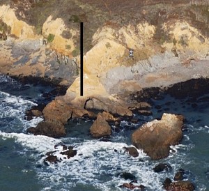
on this screengrab from that picture shows where the arch is.

Alas, more accurately, the bar indicates where the arch was.

Because when we arrived at  the promontory that it had pierced, the arch was no more. Its rocks, still un-colonized by the ocean’s opportunists, lay in ruins below where the once proud span had reached for the sky. We were bummed. A photo opportunity lost, yes, but also lost was a structure of natural beauty, one that when I last saw it seened solid, and more importantly, a permanent feature of the beach–rather than its geologic ephemerality now exposed to us, reclaimed by its creator, the waves, sadly, before we could really know it.

Picture #200810101 on CCRP, taken on October 1st of this year, show that the arch was gone by then. This screengrab

from the large file of this picture shows  the missing arch’s site clearly for those without Highspeed Internet.

Here’s the way it used to look on our first trip

and how it looks now

The last photo is a shot from above the arch showing Meg standing on its remnants.

While the arch is gone, it will not be forgotten, at least not by me. For I’ve named it. Using the W, L, and D from the Lou Denny Wayne that drew us there, the A for the arch it is, and an O for the shape it spanned, I’ll at least always know where  WALDO, the Sea Arch was. Enjoy.

P.S. Fortunately, the second goal of the trip, using the low tide to explore the coast south of Bean Hollow Beach, produced an astounding find. A natural wonder that produced as much joy as “Waldo’s” demise produced sadness. I’d like to share this discovery and its amazing neighbors in my next posting.

Posted in Arches, John Vonderlin | Comments Off on Minus Tide: What Happened to My Best Arch (MBA)? Story by John Vonderlin

Tafoni.com for Everyone! Story/Photos by John Vonderlin

Tafoni: Miniature Natural Wonders
Story/Photos by John Vonderlin
Email John ([email protected])
Hi June,

In a recent posting I referred to the new website, Tafoni.com, which is dedicated to the minor natural wonders, tafoni, for which the Coastside is ground zero. Although, tafoni are found all over the world, from the Alps to the Sahara Desert, we have the greatest concentration, and in my opinion the most interesting types right here along our Coastside.

While exploring the site, I noticed a type of tafoni new to me, and so odd that I felt I had to investigate and find some to photograph myself. This new-to-me type is called “boxed tafoni” or “tafoni with boxworks.” On the “Enter” page of Tafoni.com you can see an example if you look in the middle, towards the top of the largest picture. You’ll see what looks like rectangular, nested boxes seen from the top. If you check out the Northern California section in the Gallery at the site, you’ll see three examples of these oddities.

After the disappointment of finding the crumbled remnants of WALDO, the Sea Arch, we drove to Bean Hollow Beach parking lot and headed south along the Arroyo de Frijoles Beach. There is a small, lightly used trail up the steep hill and into the forest of tafoni festooning the ocean side of the cove’s southern promontory.

With a new appreciation of these little oddities fine-tuning my perception, I started seeing all sorts of wonderful variations of them. I was clicking my camera almost every few feet, when I was startled to see two wonderful examples of “boxed tafon”i right in front of me. Here’s what they look like in close-up. I’ll salute anyone who can clearly explain the mysterious forces that produce such an illogical, unnatural-appearing erosional feature.

If you’d like to see these tafonis, and their amazing neighbors, check out the surrounding area at Picture #200810017 on CCRP. The best concentration of the tafonis are just above the surf, directly down the page from where Highway 1 disappears behind a hill. Enjoy. John

Posted in Uncategorized | Leave a comment

1900: Were Two Huge “Kablooies” Connected?….Story by John Vonderlin

Can Anyone Explain the Explosions?

Story by John Vonderlin

Email John ([email protected])

While perusing the Newspaper Archives, I came across a couple of articles about two long ago events, that while seemingly wildly unrelated, have a strong connection to me in several ways. They both tell the story of what could be the two largest “Kablooies” to have occurred in historic times on the Coastside. Likewise, they both occurred at sites whose exact locations are now lost, turning them two minor mysteries right side-by-side on my must-find-and-visit site list. Perhaps, one of your readers can help?

The first article is from the January 7, 1909 issue of “The San Francisco Call.”
SET OFF 16,000 POUNDS OF EXPLOSIVE IN BLAST
Charge Successfully Displaces 65,000 Yards of Material
Jan.6  One of the most difficult tasks of the Ocan Shore Railroad was carried to a successful conclusion near San Gregorio, when 16,000 pounds of explosive was set off in one blast. successfully displacing 65,000 cubic yards of material. The grading between Long Bridge and San Gregorio is nearly completed.
——————————
The second article is from “The San Francisco Call,”  January 14, 1900
TWO ACRES OF LAND SUDDENLY ELEVATED

Remarkable Phenomenon at Pescadero Probably Caused by Explosion of Subterranean Gases  Santa Cruz January 13

A remarkable phenomenon occurred on Pescadero Creek at 11 o’clock last night, when nearly two acres of land thickly covered with redwoods and including a section of the creek was raised up bodily ten to fifteen feet above the surrounding land. The upheaval was accompanied by a heavy rumbling sound and is supposed to be an earthquake. A long section of the wagon road was elevated and destroyed. The elevation of a portion of the creek bottom changed the course of the stream, which had cut a wide new channel around the upraised ground. Much of the timber had been prostrated, while all that is still standing leans heavily towards the higher ground. Many dead fish were found. As there are oil indications in the vicinty the upheaval may have been caused by a gas explosion in the depths below.

————————————–

Of the two mysteries the location of the site of the enormous manmade explosion should be the easiest to solve. By studying the planned route of the Ocean Shore Railroad north of San Gregorio, I should be able to locate the site of the largest roadbed cut, which is probably also the site of the titanic explosion. Sixty five thousand yards of material are difficult to hide, even a hundred years later. Such a huge explosion deserves a story, even if its force was wasted on a route that was never finished or used. Sound and fury, yes, but much ado about nothing.
The two -acre uplift site may be more difficult to find. The reference to oil indications helps a bit, as I’ll detail in a later posting. The most interesting thing about it is, whether caused by earthquake or subterranean gas explosion, its proximity to the proposed Worley Flats Dam site might have greatly magnified its significance had it come to light during the public hearing part of the dam’s planning process. Whether a repeat of this phenomena would have produced a tidal wave of disturbed water over the dam, or caused a complete failure of the dam would have been a matter of much concern for the dam’s more catastrophically-minded opponents. That is, assuming they had ever read a small filler article in a seventy year old newspaper from a distant city. Enjoy. John
Posted in Coburn Mystery, John Vonderlin | Comments Off on 1900: Were Two Huge “Kablooies” Connected?….Story by John Vonderlin

1900: What happened to the “Pet Cannon?”

Hi June,
This is an article from “The San Francisco Call,” from January 11, 1900. I had never previously heard mention about this cannon, but will start asking around.
From John Vonderlin
Email John ([email protected])
PESCADERO’S PET CANNON STOLEN
January 11, 1900  The San Francisco Call
A Special Dispatch to the Call
REDWOOD CITY, Jan. 10  The citizens of Pescadero were greatly surprised last Thursday morning when they learned the brass cannon which has been one of the chief ornaments of the city for the last thirty years, had mysteriously disappeared in the night. Constables of nearby towns were notified and watched the roads carefully.

Constable Wagner, of San Mateo, on receiving notice of the theft, set out for Spanishtown. He had not proceeded far before he found two young men who had the captured gun carefully concealed in a wagon. They gave their names as Fred Lummis  and John Rose, and their residence as Haywards. (sic) They said they had seen the gun beside the road and thinking it had no owner placed it in the wagon.

The young men are of respectable appearance and had considerable money in their possession. They have retained a lawyer to defend them and the citizens of the little town are rejoicing at the recovery of their noisy toy.
The gun was purchased thirty years ago for $250 and its voice has been heard at every celebration in the little town since that date.
—————–
While the correspondent seemed to be unsure whether the cannon was a noisy toy, a cannon or a gun and couldn’t decide if Pescadero was a liitle town or a city, I was glad to know the defendants were of respectable appearance. But, that might be because my brother is watching a documentary on the “Dapper Don,” or the “Teflon Don,” John Gotti, near enough for me to be distracted.
I’m going to ask some of the history buffs of Pescadero, if they’ve ever heard of this or the custom of shooting the cannon off during celebrations. So far, I can find no other mention in the Newspaper Archives of what obviously wasn’t the “Trial of The Century, (even though it was in January of 1900) but will keep looking.” Enjoy. John
Posted in Uncategorized | Comments Off on 1900: What happened to the “Pet Cannon?”

Santa Claus Came Early to Smuggler’s Cove: Story by John Vonderlin

Treasures from the Sea
Story by John Vonderlin
Email John ([email protected])
Hi June,
Our recent trip to Franklin Point and Smuggler’s Cove produced a Santa Claus-sized bag of sensory presents; thundering big wave surf, the tang of fresh, salt-laden air, and sweeping, eye-popping vistas from an isolated rocky point overlooking the vast Pacific, all on a mild, sunny, nearly windless, December day. It was pure frosting-on-the-cake that the day’s trip also provided a  gaggle of ejecta oddities, freshly thrown from the deeps into the shallows for me to marvel at.

This first one is some type of egg mass. I’ve photographed other similar masses, some weighing

several pounds. But, they were all colorlesss and the eggs were much larger and opaque. Whatever creature produced these obviously has a good sense of style and color, as this is a thing of beauty, even though its presence on the beach was fatal to its crew.

I am a collector of soles. I have hundreds in storage, patiently waiting till the promised “Sole Man” piece of artplay comes to life and they are reincarnated. But none can compare in commensal hoariness with this one I found in Smuggler’s Cove. My guess is that it was wedged

somewhere, immobile for a long time, giving the constancy of environment necessary for the barnacles to grow. Only when the leather top rotted was the sole released to be borne  into the upper world and into my hands.

While out at the end of Franklin Point Meg noticed this little Mini-Me sea arch. I wanted to add it

to my catalogue of Coastside sea arches, so I climbed down to photograph it and was given a little surprise, with a foam topping.

The different kinds of tafoni at this spot are spectacular. Here’s a few pictures of what is called

honeycomb tafoni. I found a new website, “tafoni.com” that explains some of the mysteries about this unusual phenomena as well as cataloging its types.

The last oddity of the day was this unusual rock I found on our way home. Fossilized donut?

Bagel? Product of molluscs? It is almost surely natural and yet the central hole is so circular and straight-sided that it would seem to rule out a piddock clam as the creator.

Whatever its source it was a nice finish to an interesting buffet of nature’s oddities that day.  Enjoy. John

Posted in John Vonderlin, Smuggler's Cove | Comments Off on Santa Claus Came Early to Smuggler’s Cove: Story by John Vonderlin