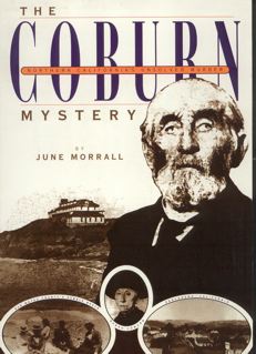
Coburn Mystery: Chapter 29 (Original Draft)

By June Morrall

(Photo: The Swanton House.)

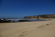
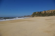
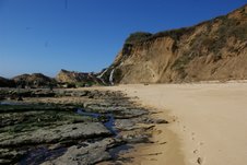
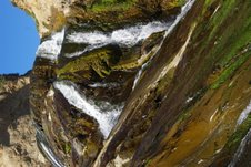
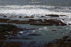
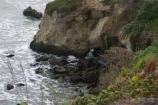
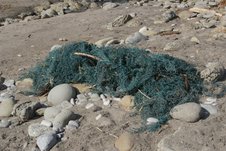
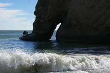
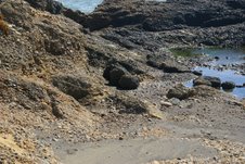
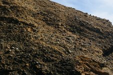
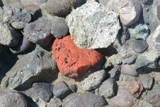
The shoreline of Pebble Beach was rocky, and the pebbles, or stones, that been rolled and tumbled by the tides until they were polished smooth were ankle deep. The bright pebbles ranged in size from “a shot to a marble;” there seemed to be an endless variety of colors and shapes. There was a magnetic quality about them–and the place was enchanting.

“The wind blows there like the blazes sometimes,” said pioneer Alexander Moore.

But the strong winds didn’t affect the beach’s reputation as a special place to visit, especially by the nearby community of Pescadero. In these early years, Pebble Beach was the glue that brought the villagers together, for picnics and celebrations of all kinds–the pebbles and the sand on which they lay became sacred ground.

When Moore, a farmer, was nearing 70, he said it wasn’t the pebbles that he was interested in, but, “What took me there mostly was to get something good to eat…” He’d never picked up more than a dozen pebbles off the beach.

“Well, usually when I went there, I went to take ladies and children,” said the dairyman Issac Steele, “to go pick pebbles and play on the beach and picnic….”

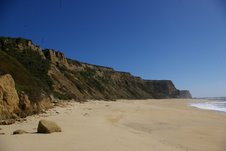
Steele said he first rode horseback over the well worn trail to Pebble Beach in 1863. He suspected that were it not for the fascination of the pebbles, fewer people would visit Pescadero. Moore agreed with his neighbor. “…The people find Pebble Beach a nice place to go and lie down and wallow around in the pebbles….”

The highly respected businessman J.C. Williamson, who settled in Pescadero in 1869, visited Pebble Beach “quite often…I have averaged 10 or 12 trips each year.” In 1895 he recalled seeing two or three hundred picnickers there at one time. He had something to say about the road to the beach as well, noting that the people had created the road with their horses and carriages. The road was well worn with chuck holes filled by the local stablemen who brought visitors to the beach.

Henry B. Adair, the roadmaster, who moved to Pescadero in 1875, noted: “…the first time I ever was at Pebble Beach was, I guess, not more than a week after I arrived in Pescadero.”

“If a fellow wanted to take his girl,” said I.C. Steele, “he took her on horseback, either behind him or in front of him….” He remembered “wagon-loads, lumber wagons, there was scarcely anything else in the county there at the time,”–the time being the decade from 1862 to 1872, the years that the Steeles leased the southern portion of the Rancho Ano Nuevo from Loren Coburn.

The pebbles were the big draw at Pebble Beach, but fishing from the rocks was a popular pasttime, too. Alexander Moore observed that “..there is hardly a day that passes without some people driving by my house with a fishing pole tied to their buggy.”

Posted in Coburn Mystery | Comments Off on Coburn Mystery: Chapter 29 (Original Draft)

Where the Sand Goes….John Vonderlin Shows Us…..

Where the Sand North of Half Moon Bay Goes

Story & Photos by John Vonderlin

email John ([email protected])

Hi June,

At one point in an email you wondered where the sand from beaches in your area had gone. Here’s a few pictures of Secret Beach that offers part of the answer. It has some of the widest and most generously gifted-with-sand stretches I know of on our coast. I sure hope this resource can be opened up to the the public who don’t own kayaks. Enjoy. John

s1.jpeg

s2.jpeg
s3.jpeg

s4.jpeg

s5.jpeg

Posted in Coastside Beaches, John Vonderlin | Comments Off on Where the Sand Goes….John Vonderlin Shows Us…..

Secret Beaches: What John Vonderlin Saw At Purisima Falls….

Secret Beaches: What John Vonderlin Saw At Purisima Falls

Story & Photos by John Vonderlin

email John ([email protected])

Hi June,

By far, the highlight of the trip to Secret Beach was viewing the Purisima Creek Waterfall. It’s definitely the most spectacular coastal waterfall in San Mateo County.

My hope is that the planned bluff trail, with its nearby parking lot, will, someday give many more people a chance to view this stunning waterfall as it cascades down from the cliff onto a huge rock, and is subdivided into multidirected ribbons that flow into the sea at this isolated spot. (Cowell Purisima Coastal Trail Project)

Half Moon Bay Review.com (/articles/2007/10/19/news/local_news/story06.txt)

You can see the falls in Picture #6159, shot from a helicopter from a long distance on the California Coastal Records Project website, or enjoy it up close in the following pictures. I hope some day everyone gets to experience this unique area up close as I did. It truly is one of the crown jewels of the San Mateo Coast. A hidden gem so unknown you won’t even find out about it by websearching. That seems a selfish crime. Enjoy. John Vonderlin

ca1.jpg

ca2.jpg

ca3.jpgca4.jpg

ca5.jpg

Posted in Coastside Secret Beaches, John Vonderlin, Purisima Falls | Tagged , | Comments Off on Secret Beaches: What John Vonderlin Saw At Purisima Falls….

Secret Beaches: John Vonderlin Shows Us Coastside Beaches Few Have Seen…

Secret Beach

Story by John Vonderlin

Email John ([email protected])

Hi June,
I recently got to explore a section of the San Mateo Coast that is virtually unknown to most Coastsiders.

Have you heard of places like Seal Rock, Eel Rock, Poppy Point, Secret Beach or Purisima Falls? Well, neither had I until I began to investigate this isolated, and virtually never-visited two mile stretch of the coast, just a short distance south of the Ritz Carlton Hotel. There are good reasons that this stretch is unknown to most people, it’s inaccessible and mostly unviewable to the general public from dry land. Only boaters or kayakers willing to brave the many shallowly-submerged or jaggedly-jutting rocks just offshore, and the typically rough surf, or the long paddle from the nearest launch spot can tread its virginal sands.

You may have gotten a glimpse from afar of a small part of this spectacular series of beaches if you’ve visited the Cowell Beach Access Viewpoint. From atop a high blufftop viewpoint you get an eagle’s eye view of the mighty Pacific Ocean and its interface with our continent. To the north are the sands of Cowell Beach, down a long, but easy- to- navigate staircase. Directly below you is an unclimbable rock spine stabbing into the ocean

067.jpeg

barring any beach-goers travel southward. To the south a broad sand beach disappears from view behind a promontory of the sheer cliffs.

071.jpeg

Offshore to the south on the reef, composed of large, flat, low-lying rocks, broken by numerous channels, are scattered groups of Harbor Seals, lounging in the sun, safe from predators and bothersome humans.

05.jpeg

This area is a Protected Area closed to the Public. Please give them a wide berth as you paddle by, as they are much more skittish then other groups more used to seeing passing humans.

040.jpeg

Paddling to the south of the Protected Area there are more open stretches of the beach with fewer rocks where you can make a relatively stress free landing, provided you’ve used commonsense in regard to swell size and wind speed. Once ashore, if you’ve chosen a low tide period, you can traverse the next mile-and -a- half south with only a few seaweed slickened, risky passages. You can identify those areas by studying the large file photos of this area on California Coastal Records Project CCRP. Start at Photo #6147 which shows the Cowell Access Viewpoint, and begin your virtual cyber tour which ends at what I believe is Poppy Point, Picture #6167.

Poppy Point is the end of the line for southward beach travel.

079.jpeg

The sheer cliffs from there to just north of Martins Beach have no beach at their wave-battered bases. They do, however, have the greatest number of sea caves of any stretch of the San Mateo Coast, and possibly any stretch of the California coast, at least that I am aware of. There are way more then fifty in the mile- and- a- half south to Shark Fin Rock, including several very large ones shown in Picture #6169. This summer, with any luck, I’ll be posting a picture of what some of these caves look like from inside looking out. Enjoy. John

…More Coming…..
.

Posted in Coastside Secret Beaches, John Vonderlin | Comments Off on Secret Beaches: John Vonderlin Shows Us Coastside Beaches Few Have Seen…

Coming Soon: “Secret Beach,” By John Vonderlin

Wow!

Coming Soon………

Watch for “Secret Beach” by John Vonderlin…….

sb.jpg

Posted in Coastside Secret Beaches, John Vonderlin | Comments Off on Coming Soon: “Secret Beach,” By John Vonderlin

A Rare Double Arch, A Boring Arch…& More…Story & Photos by John Vonderlin

A Rare Double Arch, A Boring Arch & More

Story & Photos by John Vonderlin

email John ([email protected])

Hi June,

After the cemetery tour, and our visit to “The Gravel Quarry,” we headed down to Ano Nuevo for a hike. My main purpose was to photograph the most southerly sea arch in San Mateo County.

It’s located at the northern limit of Cove Beach, a popular surfing spot at the south end of the park. You can access the cove by paying $6 to park at the State Park parking lot and taking a fairly boring hike along with all the other tourist families, or you can park for free about a half- mile south of the Park alongside Highway 1, and hike along the old access road, over the old bridge, and down the New Year’s Creek path to the beach and head north. (CCRP Picture # 200506697)

With breeding season over, most of the adult male Elephant Seals have left. But, there was one lone male sunning himself

a.jpga2.jpgon the beach as I headed towards the arch. He looked so relaxed, I approached to within the legal distance of 25 feet, a bit closer then I recommend, and got some good photos.

Unfortunately the tide was in, so I didn’t get the close-up photo of San Mateo’s most southerly arch that I was aiming for. But it’s not that impressive anyway.

ddjpg.jpg

It is, however, the only arch of a series of arches that you can walk through, and that are hidden in this south- facing- part of Ano Nuevo Point.

When the seals are gone I’ll kayak along this stretch, and inventory, and photograph all of them. Though I can’t be sure just how many there are despite studying the California Coastal Records Project (CCRP) pictures.

Heading south, I photographed another large neta6.jpg

embedded in the sand. It seemed to be a part of the net I recovered on my last trip to this area. This time, without the tools to cut the net up, I just had to leave it for another time.

I also photographed the nearby “Elliot Falls,”a4.jpg

the second most southerly, and perhaps the most picturesque of all the oceanfront waterfalls in San Mateo County. (CCRP # 200506703)

Then it was into the Park, to take that boring walk I mentioned.

At the Ranger Assembly area, where the guided tours to the Elephant Seal rookeries begin, there is a side path to a viewpoint on the bluff-top, I knew a small sea arch was visible from there, having studied the CCRP pictures. It turned out to be a fairly rare double arch, perhaps the only one in San Mateo County.

orindaryarch.jpg
Unfortunately, the picture doesn’t really show the double arch. I could only be sure it was a double arch, because, when the waves moved through the arch-opening, they also surged out of its nearly submerged smaller companion. (CCRP # 200506688)

With the sky clouding up, and the seemingly perpetual cold wind that blows out on the point gaining force, we called it a day. Another small slice of the amazing San Mateo Coast caught in both my camera’s SD card and my wetware memory bank. Enjoy. John

Posted in Coastside Arches, John Vonderlin | Comments Off on A Rare Double Arch, A Boring Arch…& More…Story & Photos by John Vonderlin

Coburn Mystery: Chapter 28 (Original Draft)

By June Morrall

“The only road to Pebble Beach was ‘a kind of a zig zag…never laid out by anybody…[and it looked like]…a cow trail because it was crooked, but wider because wagons crossed over it…”–Alexander Moore, Pescadero pioneer who built the first wood frame house in 1853.

Nobody knew where the shiny, colorful pebbles that covered Pebble Beach came from, so the beach was tagged a “nautical wonder,” a “geological freak.” There were theories, though: Half of the townfolks said the glacier of pebbles originated in the cliffs and were pulled into the Pacific. The other half said the tides brought them to Pescadero from somewhere else.

Roma T. Jackson, the controversial editor/publisher of the Coastside Advocate often wrote of Pebble Beach and its charming little pebbles.

“Many are valuable gems,” Jackson wrote, “such as carnelians, opals, cats eyes, agates, moonstones and water crystals making it a profitable as well as a pleasant pasttime to search the pebble banks.”

All this was hyperbole, making Pebble Beach sound like a big beach teeming with priceless jewels, similar to the Great Diamond Hoax (1872) where the pricey, glittering stones were said to be growing on the ground and in trees.

Pebble Beach was only a quarter mile in width and several hundred yards long.

“The first that I knew of it being called Pebble Beach was in 1864,” Alexander Moore said. “I heard them talk about the pebbles….A lady by the name of Hale, an old lady that used to come down from a boarding house and a fellow by the name of Bill Carr…Ever since that time Pebble Beach has been a place of public resort.”

…more coming..

Posted in Coburn Mystery | Comments Off on Coburn Mystery: Chapter 28 (Original Draft)

If you want to buy a copy of my “Coburn Mystery” book, it’s

available at the San Mateo County History Museum in Redwood City. There’s ten copies at the museum and I am running out of the book.

coburncover.jpg

Posted in Coburn Mystery | Comments Off on If you want to buy a copy of my “Coburn Mystery” book, it’s

The Legacy of Daniel Durigan…Story & Photos by John Vonderlin

The Legacy of Daniel Durigan

by John Vonderlin

email John ([email protected])

Hi June,

I recently received an email from a gentleman who had just read in your blog about my favorite headstone in the Mt. Hope Cemetery in Pescadero: the one for Enos Ralston. dd2.jpg

He related to me that he and a friend were looking through some photos he’d taken twenty years ago and came upon one he had taken of the grave marker. His friend opined that the epitaph, (the reason it’s my favorite), must have been composed by somebody famous.

After online research he found no evidence of that and thought not. He did come upon my essay and asked if I wanted to look at his picture. Of course, I wanted to see it, and moreover it reminded me that I had wanted to return to the cemetery to check out a new marker I had recently read about. So I did.

The grave marker I wanted to see is for Daniel Durigan, dd.jpg

the owner for 38 years of Durigano’s Nursery on Highway 1, south of Pescadero. Durigan was an avid rock collector and lapidarist. After his death, it was his wish to give his extensive lapidary tool collection to the Pescadero High School. Several students have begun exploring careers in lapidary because of Durigan’s generosity. I consider that one of the finest and possibly longest-lasting legacies one can leave.

The positive effects of Daniel Durigan’s gift were manifested when one high school student used his tools to create a grave marker for Durigan, using an unusual type of local marble from Durigan’s collection and an inset of jade found off our shores, especially at Jade Cove, in the Big Sur area.

While I was at the cemetery photographing Daniel Durigan’s grave marker, I noticed how spiffed up the entire cemetery was, compared to when I was last there. I suspect that is the work of Ed Weeks, the great, great, grandson of Brandon Weeks, one of Pescadero’s founders. Five generations of Weeks’ family are laid to rest at the Mt. Hope Cemetery, including Ed’s grandmother, Annie Weeks, and his first wife.

In the Weeks’ family plot was a new headstone commemorating William Dewlaney,dd3.jpg

who died last year. His epitaph is the sort I might want if I didn’t favor cremation and oceanic dispersal, William Dewlaney 1938-2007 A COLORFUL CHARACTER. Enjoy. John Vonderlin

Posted in Daniel Durigan, John Vonderlin, Pescadero Hgh School | Comments Off on The Legacy of Daniel Durigan…Story & Photos by John Vonderlin

Not the most exciting place: John Vonderlin Visits “The Gravel Quarry”

Story & Photos by John Vonderlin

Email John ([email protected])

Hi June,

As you know my avocation is to explore every legally accessible inch of the San Mateo coastline. I just added a short, but interesting, stretch yesterday that the locals used to call, “The Gravel Quarry.”gq.jpg

I’ve known about this area for some time, but had been “creeped-out” by the circumstance surrounding the access to this unusual, perhaps unique chunk of our coast.

Most of the areas I visit are isolated, lonely spots where you see no one and no one sees you. But here you park in front of somebody’s house, walk through a hole in a privacy fence, and stroll alongside their driveway and house until you reach a picturesque point.

When I first made a serious attempt to visit here a few months ago, I found several new four- by- four posts, with their signs removed, where I had been told the access was. I didn’t like the vibes, let alone the creepiness of seemingly trespassing on somebody’s property.gq1.jpg

Unsure, I contacted Linda Locklin, the California Coastal Commission Public Access Officer, about the reputed access, and what I thought might have been vandalism of the sign posts by nearby property owners, perhaps unhappy at the public visiting their gorgeous bit of coastline. I was in the right place but was wrong about the missing signs. It seems that CalTrans had put up the wrong signs as specified in the agreement reached by the government and the landowners and then had to remove them. They are on interminable back order and should be reposted eventually.

Armed with the knowledge that the law was on my side, and familiarized by an article written by Lennie Roberts of the “Committee for Green Foothills,” all about this place, (found at: greenfoothills.org/news , I finally decided to check it out. I’m glad I did, although it’s not one of the top places I’ve visited on my San Mateo coastside visits but it does have its own charm.

gq2.jpg

While looking at Picture #6291 on the California Coastal Records Project, I was mystified why it was called “The Gravel Quarry,” but a visit quickly cleared that up.

The rock at this point is composed of an unusual conglomerate of millions of rounded river rocks cemented together. It looks like people long ago could drive right down to the shore and load up, using picks and shovels or a front-loader. The historic use of this resource, and the longtime popularity of fishing from the nearby rocky points, allowed the California Coastal Commission the right to demand access from the people who bought the property and built a house.

Besides the view, and a couple of nice sea caves below the bluff, and the right to walk south for a hundred yards, there was only one other thing of note. While I was standing on the cliff, I repeatedly observed “a rainbow spume effect.”

gq4.jpg

The waves entering some feature in the cliff below me were rebounded in a cloud of fine spray in which the afternoon sun was producing a persistent rainbow. As always, my photographs didn’t capture things as well as my eyes, but I’ll attach a photo anyway.gq3.jpg

While we all have the right to visit this spot, I would urge everyone that, if you do, please be sensitive to the privacy and property rights of the nearby landowners. It’s not only the right thing to do, but pragmatically strengthens the Coastal Commission’s ability to restore the public’s right to access our beaches elsewhere without the angry, litigious, and potentially violent confrontations, that June recounted in her book, “The Coburn Mystery.” Enjoy. John Vonderlin

Posted in John Vonderlin | Comments Off on Not the most exciting place: John Vonderlin Visits “The Gravel Quarry”