Warning: I Hate To Spoil The Fun…But Adventures Can Be Dangerous To Your Health

“Dropping Into Acid Beach,” Part I

Story & Photos by John Vonderlin

Email John ([email protected])

Hi June

The news yesterday that a young woman fell to her death from a coastal cliff trail above Rodeo Beach, in Marin County, had me vacillating on writing the story about my trips to Acid Beach. Oddly, the freakish story of a woman dying from a redwood branch falling on her in Stern Grove, on the same day, decided the issue for me.

Danger is everywhere and risk lies hidden in all of our actions.

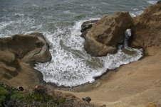
That said, on this expedition risk isn’t hiding. It’s jumping up and down, waving its hands wildly, shouting out your name. There is no trail down the sheer one hundred- foot cliff to the beach. The rock is incredibly crumbly; upon contact it breaks apart, and the pieces that break off look and feel more like shards than rocks.

The icy cold ocean, with its surging surf, waits below to deliver the coup de grace if you should somehow survive the fall.

Your screams for help are not likely to be heard by the very few people I’ve ever seen that stop at the nondescript pull- off above the cove, and bushwack their way through the poison oak to the edge to look down.. There’s no cell phone reception, no nearby public telephone, and any medical care or emergency aid is going to take an eternity to come to your aid.

If that doesn’t dissuade you, please, please, please do not do this alone, as I did my first time last week. Do it with a partner, or like we did my second time, with a “911 duty station officer” (a friend who doesn’t like heights that deserves the lofty title for sitting on the bluff-top and watching your progress below).

Bring a rope too, as the few meager handholds I used to climb back up the first time have fractured further, and look ready to break free, sending you and an unknown quantity of rock falling together in a scene worthy of a Coyote and Roadrunner cartoon, with results nowhere near as funny.

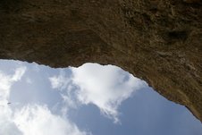
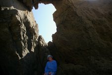
Lastly I’ve attached a picture looking up at the cliff from the beach as a reminder that things falling down and hitting you (including your exploring partners, or rocks they might loosen) pose a danger as relevant as you slipping and falling.

Even with all this in mind, I can still hardly wait until my schedule and the low tides that make exploration of this area easier, coincide, so I can return. I hope when I return to my keyboard for the next part of this story, I can find the words, and select the pictures, that will do justice to this stunning stretch of coast and its natural wonders. Enjoy. John
Posted in Uncategorized | Comments Off on Warning: I Hate To Spoil The Fun…But Adventures Can Be Dangerous To Your Health

Acid Beach and Beyond

Hi June,
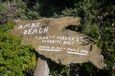
I’ve made two successful trips to Acid Beach in the last week. Both were dangerous and exciting, but extremely rewarding. I need some time to organize the stories, but I thought I should share a related item to a previous posting now. After the climb down into Acid Beach and the more perilous climb out, we visited the so-called Prankster rappel spot south of there that I’ve written about previously. Larry F., was able to find the Amb’s Beach sign he mentioned in his email.

It had fallen over and was hidden in the underbrush, but still bristling with mystery. I’d love to know who Monty Parker was, what killed somebody so young, who must have been extremely physically fit to rappel down the cliff to reach “his” beach, and why and who went to the effort to memorialize him in such a touching way?

It turns out the spot I thought was the rappel spot, what I considered a sure trip to the Emergency Ward, was not the actual rappel spot. The actual spot was about a 100 feet north and had three different pipes and a chain sunk into a subterranean concrete block that had been used as anchors to secure a rope at various times. While the cliff was not as fractured as where I thought the site had been and there was no stream to slicken the footing, if the Pranksters used this spot to access the beach below, somebody must have had some serious technical climbing skills. Much more on this soon. Enjoy. John

P.S. Check out this Y-shaped double arch, or is it a triple, on the south end of the tiny cove between Warm Water Lagoon and Acid Beach.

Hands down, this is the best arch on our coast. Next trip I’ll have pictures from inside it. On the north side of this fifty foot wide cove is this other sea arch/tunnel leading to Acid Beach.

If you don’t mind getting your feet wet or if there is a minus tide of more then one foot, you can walk all the way through this. I can think of no fifty foot stretch of the California Coast that rivals this tiny, unnamed and almost unreachable cove.

Posted in Acid Beach, AMB Beach, John Vonderlin, Monty Parker | Comments Off on Acid Beach and Beyond

June 1980: Pescadero’s Flagpole Makes A Comeback

From “The Beachcomber: A Coastside Magazine,” June 3, 1981

Pescadero’s Flagpole Has Returned

By Charles Jones

If a town’s persistence can be chronicled by its dedication to a flagpole, Pescadero will last forever, and on its own terms. All the citizens of Pescadero own a piece of the pole set in place on May 22 of this year [1980.] It was not the first or most feisty pole setting in town.

Who had the idea to begin with, and even how the first flag pole got to town, is in some doubt. There are those who say the Native Sons of the Golden West first asked for the pole. And it has been written that Frank Bloomquist in Loma Mar brought out and donated the first pole, in 1916.

Most agree that was the year, but Billy Weeks used to say he cut the tree, a 131- foot pine. From 1916 to 1961 the pole stood in the center of the intersection of what is now Pescadero Creek Road and Stage Road. Weeks said it took two days to get the tree to Pescadero, and four men to put it up.

In 1961, when Pescadero Creek Road was being widened, it took San Mateo County engineers much less time than that to cut the pole down. The people of Pescadero were not amused. They were infuriated.

Determined not to lose the pole, the townspeople mounted a campaign to have the pole put somewhere near its familiar site of 45 years’ standing. The county suggested putting the pole at the high school, about a mile from town. Said one of the town’s leaders Earle Williamson, “They treat us like a bunch of hayseeds here. We’re sick of being pushed around.”

County supervisors, engineers, and other officials have learned that very thing in many ways since the “Great Flagpole Rebellion.”

Pescadero got its flagpole back, and the county put it where Pescadero wanted it. The same pole as replaced, off of Pescadero Creek Road, in the center of Stage Road By then John Rich was chairman of the Flagpole Committee. It was a victory for what one supervisor ill-advisedly called “the boondocks.” That does not happen any more.

Billy Weeks once said, “I didn’t like it a darn bit when they cut her down.” If he had still been alive in December, 1979, a few days before Christmas, he might have at least accepted what happened. In high winds, the pole fell, shattering the parking lot of what is now the post office. One could not say, as the county had in 1961, that “the flagpole has been temporarily removed and is being repainted.”

Nature has no such words to try to get out of its acts gracefully.

Fortunately, Pescadero had another Weeks, Ed, who is not, as far as he knows, related to Billy, but who family in the area goes back over a hundred years. Ed Weeks remembered a youth fund, started over 20 years ago by Peggy Olsen, for a swimming pool. The fund was there, had grown. Ed Weeks talked, he called, he got estimates and he began again to raise the Pescadero flagpole.

This time the 90-foot flagpole is fiberglass set in concrete. The golden orb, the flag, all is done. Continuing contributions over the $7000 cost will go toward flags and replacing the youth fund for some other project.

In town, patriots and cynics alike, agree that the flag gives a dandy dress to the town. What else could one want?

Well, perhaps a little swearing. When the flag and pole were officially dedicated–sworn, as it were, on May 30th, some might have thought, in the right spirit of the thing, Billy Weeks. He said, “One tme they asked me to make a speech about the pole. I told them I couldn’t make a speech without swearing in it.”

Posted in Uncategorized | Comments Off on June 1980: Pescadero’s Flagpole Makes A Comeback

1914: Pescadero’s Lafayette Chandler passes….

From the Redwood City Democrat, April 9, 1914

Lafayette Chandler Pescadero’s stalwart old citizen for over half a century, passed away Sunday after a long illness. His burial took place at Cypress Lawn…Mr. Chandler was a native of Maine, aged 77 years. He left his native state when 16 years of age and came to California via the Nicaragua route. His arrival at the Golden Gate was the prelude to a startling adventure, the ship on which he sailed, going on the rocks during a dense fog and becoming a total wreck. All of passengers were taken ashore in boats. Mr. Chandler landed in San Francisco in 1859. Shortly afterwards he went to Santa Cruz, then returned to this county, residing awhile at Searsville, after which he located permanently at Pescadero.

He was twice married and is survived by his wife and one daughter, Mrs. Asa Weeks…

Posted in Uncategorized | Comments Off on 1914: Pescadero’s Lafayette Chandler passes….

1922: Pigeon Point Schoolhouse Burns……

From the Coastside Comet, published in Montara, December 1922

The grammar school of the Pigeon Point district was burned to the ground at six o’clock on Tuesday morning, by a fire of unknown origin. Following a report received by his office, Superintendent of Schools Roy W. Cloud went to Pigeon Point yesterday and made an investigation.

It was found that abalone hunters passing the schoolhouse at 2 o’clock in the morning had seen a light, and upon looking in the windows had seen several people, apparently campers, asleep on the floor. The abalone hunters went on their way without disturbing the sleepers. At 6 o’clock residents of the vicinity saw the building suddenly break into flames, and before anything could be done the entire building and contents were destroyed.

The school, which would have closed for the Christmas vacation on December 10, was forced to close immediately on account of no other building being available. Arrangements are now being made for the securing of the Wiedemann dance hall, which was across the road from the school. When these arrangements are completed, the dance hall will be put in shape for use as a school room, and it is thought will be ready for occupancy following the Christmas vacation.

“The burning of this little school was very unfortunate,” said Superintendent Cloud in speaking of the fire yesterday. “The campers who were seen sleeping on the floor are and thought to have left some fire in this building when leaving. However, we have no means of knowing definitely who they were or which way they went when leaving the school…”

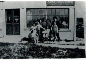
(Photo: Friends & Staff fooling around in front of the Coastside Comet’s office in Montara.)

Posted in Uncategorized | Comments Off on 1922: Pigeon Point Schoolhouse Burns……

…Then & Now….Once the Centerpiece: Purissima Falls….

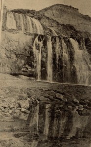
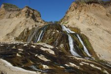
(Photo: Purissima Falls. L-R, Courtesy San Mateo County History Museum. John Vonderlin.)

You can read more about Purissima, the town that could have been Half Moon Bay. Click here

You can email John Vonderlin; he’s been to Purissima Falls: ([email protected])

Posted in John Vonderlin, Purisima Falls | Tagged , | Comments Off on …Then & Now….Once the Centerpiece: Purissima Falls….

“Two-fer”: Arch & Tunnel…Story by the South Coast’s Great Adventurer John Vonderlin

“Two-fer”

Story & photos by John Vonderlin

Email John ([email protected])

Hi June,

Our April Fool’s expedition to the coast, trying to locate a hole in the ground where the Mystery Tunnel might have been, didn’t satisfy our sense of adventure sufficiently, so we utilized the low tide to continue up the beach from the most northerly parking lot at Pescadero Beach.

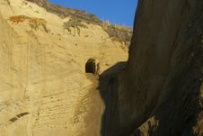
About 1500 feet north from where you start skirting the ocean-side cliffs, you can see the W.W.II Observation tunnel above you in the cliff-side.

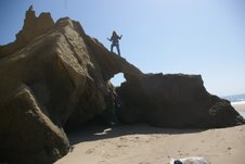
But, our goal was some 100 feet closer then that. I wanted to photograph one more of San Mateo County’s Sea Arches. This one is relatively small, but nicely formed, with enough cracks in its thin span to give an ephemeral quality to it. I wouldn’t say it has the cachet of the world famous “Delicate Arch,” but it does have some of its qualities and it’s a whole lot easier to reach.

My new modus operandi is to climb on top of the arches and have myself photographed. It seems a time-honored method, as many of the historical photos of Sea Arches have somebody or a crowd of folks or even two horse and buggy teams on top of them. It serves the purpose of providing scale, as well as generating a human interest angle, at least to the photographed.

Should you want to visit this “twofer,” the arch and the W.W. II Observation Tunnel, you can locate them on Picture #6248 at the C.C.R.P. website. Unfortunately, because of the angle the photograph was taken from the helicopter, you can’t see either of them. The tunnel mouth is in the canyon right in the middle of the picture. It is just above and to the left of where the seasonal waterfall drops off the cliff to several large rocks on the beach, but hidden by a small ridge.


The arch is just about a hundred feet south of the waterfall in the promontory projecting out from the lower part of the cliff. Enjoy. John

Posted in Uncategorized | Comments Off on “Two-fer”: Arch & Tunnel…Story by the South Coast’s Great Adventurer John Vonderlin

John Vonderlin Says: I think I found the “Mystery Tunnel!”…

Mystery Tunnel

Story & Photos by John Vonderlin

Email John ([email protected])

Hi June,

Angelo’s email confirmation that there used to be a tunnel, possibly associated with the Ocean Shore Railroad, just north of the most northerly Pescadero Beach parking lot was reason enough for me to try again to find the tunnel, or at least locate where it had been.

Various people have described the tunnel as an initial “bore tunnel” for the O.S.R.R. as well as an explosives storage site for construction of Highway 1, which, I believe, was built on the O.S.R.R. right-of-way in this area.

During the past few weeks, I’ve stomped all over the area, and found no sign of it, but I was LOOKING FOR A TUNNEL. This time I was basically looking for SIGNS OF WHERE A TUNNEL HAD BEEN. Lowered expectations can often lead to success. And, I believe I’ve found where it was.

I suspect, just as with the Prankster’s tunnel, and the nearby W.W. II observation tunnel, that the authorities have eliminated what they considered to be a public nuisance. Having explored many mine tunnels, shafts, etc. in the Mojave Desert, I can understand why they’ve done so, but it’s sad that history was also obliterated along with the danger.

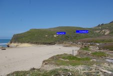
Here’s a picture of the hillside just north of the parking lot.

I’ve marked where I believe the tunnel was. I believe this is so because it’s the only anomaly on a generally smooth hill and there seems to be the remnant of a road that runs up the hill and passes just below it disappearing slightly further on.

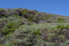
Here’s a close-up shot of where I believe the opening was.

On the California Coastal Records Project (CCRP). website, if you look at 7218061, you’ll see what the area where the tunnel was looked like in 1972. Unfortunately, the angle and clarity of the image doesn’t allow me to see exactly what was there besides a couple of paths.

Lastly, I’ve attached a photo shot from slightly above and slightly to the west of the tunnel.

I assume the footprint of Highway 1 is pretty much the O.S.S.R. right-of-way. In author Jack Wagner’s excellent book, “The Last Whistle,” he inserted a chart showing the size of the completed and proposed trestles for the railroad. The Pescadero trestle, never built, was to be only 36 feet high, but 375 feet long. That would neatly carry it from the bedrock near where the present bridge is anchored on the south end, over the Pescadero Creek riparian corridor, to the slightly higher and more solid ground of the low ridge that separates the Pescadero Marsh from the dunes.

Looking at the 1972 CCRP pictures,(#7218063 to 7218065) you can see this ridge has changed very little over the last 35 years, while a considerable amount of sand on the beach has disappeared. Given these facts, I suspect it’s likely that the tunnel stored explosives for construction of the railroad and/or the highway. Perhaps, somebody out there has a picture or knows for sure. Enjoy. John Vonderlin.
.
M

Posted in Angelo Misthos, John Vonderlin, Ocean Shore Railroad, South Coast Tunnels | Tagged , , | Comments Off on John Vonderlin Says: I think I found the “Mystery Tunnel!”…

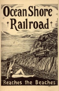
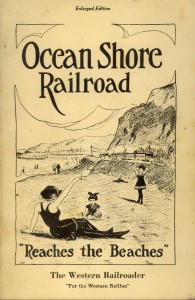
Ocean Shore Railroad Pamphlets….

Posted in Uncategorized | Comments Off on Ocean Shore Railroad Pamphlets….

What Happened to the Palmer Gulch Trestle? John Vonderlin Tells Us…

Wrestling with the Trestle Truth

Story by John Vonderlin

(email John; [email protected])

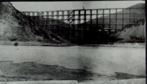
(Photo: trestle at Tunitas Creek)

Hi June,

Angelo’s email about the fate of the Palmer Gulch Trestle stimulated me to do a little research. I had stated in my story about our pilgrimage to the trestle, that a fire caused its collapse.

Angelo’s sources said that it had collapsed by itself.

My belief was based on being told that it had been set on fire, coupled with the paucity of remaining timbers, and the fact that most of those were fire-scarred. Nonetheless, he was right. I now believe the trestle collapsed over a period of more than a decade, and was severely scavenged after it collapsed. Then its remains were set on fire.

Here’s why:

If you go to the California Coastal Records Project (CCRP) website, and look at the 1979 Picture #7928080, you can clearly see the trestle has collapsed. The right side of the canyon has a long intact stretch of the roadbed (or whatever you call the top where the rails would have been laid) slumped into the canyon, but still mainly intact. The left side of the canyon has an impressive “Pickup Stick” pile of timbers littered across the slope below the right-of-way.

The 1972 Pictures #7218035 (&6) show the left side of the trestle to be collapsed, but with some of the superstructure still standing. The roadbed on the right side is also collapsed, but can’t be seen as clearly as in the 1979 picture because of the quality of the photo.

Meg tells me that after our trip to the trestle, she attended a meeting where she met a gentleman who related how he had scavenged heavy timbers from the trestle to support his waterbed.

(The modern waterbed was first created by Charles Hall, San Francisco State University student in 1968, after trying unsuccessfully first with cornstarch, then Jell-O. ) I suspect, with vehicle access to the beach from several roads, both the north and south, he was just one of many who valued the timbers for their functionality and/or provenance.

Though I’ve heard second-hand that the remains were set on fire, I don’t know when or if it was deliberate. It must have been done in wet weather as there is no sign of a burnt landscape in the 1987, 2002, 2004. or 2005 pictures. Maybe somebody out there knows the details.

Thanks for pointing me in the right direction, Angelo. Enjoy. John Vonderlin

Posted in Uncategorized | Comments Off on What Happened to the Palmer Gulch Trestle? John Vonderlin Tells Us…