The Coburn Mystery: Chapter 37 (original ms.)

By June Morrall

In the 1870s, the “burg” was booming. That’s what some folks called Pescadero, “the burg. It was hopeful talk of a railroad linking Pescadero with San Francisco that led to all the building. Why was this so important at that moment in time?

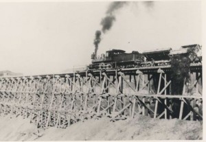
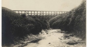
If you read Angelo Mithos‘s enlightening post below (“What You Didn’t Know About the Ocean Shore & The Butano), you’ll see that the city of San Francisco, post Gold Rush, was developing rapidly and hungry for wood to quickly build more houses. “The Butano’ forest, thick with redwood trees, was so close, yet so far because there weren’t any good roads.* Talk of building an iron road along the Coastside raised many new possibilities.

The people behind the new railroad held community meetings in Pescadero to discuss the project, but they were in town mainly to raise the funds to build it. Meanwhile the locals got to work, drawing up plans for new buildings.

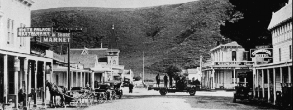
The two-story, $31,000 McCormick building was under construction, said to be a big “attraction on the road.” On the first floor there was a warehouse; on the second floor a public hall with a suspended platform where musicians performed.

On San Gregorio Street (Stage Rd) there were two blacksmith shops; Goulson repaired wagons and Koster specialized in shoeing. There was a market, a harness shop, barber, two livery stables, an express, telegraph and post office.

There were three saloons in the village with a population of 300. Teetotalers were free to join the Temperance Society headquartered in the Methodist Church.

In 1874 instead of being a town built on two sides of a creek as it had been, Pescadero now presented a four-cornered front.

That year Library Association members celebrated their 8th anniversary, proclaiming that theirs was the oldest library on the entire Coastside. [Remember, there was always a humorous rivalry with Spanishtown [Half Moon Bay], the bossy town to the north.]

Education remained high on the list of priorities with a brand new two-story, four-room schoolhouse ready to go from the drafting table to reality. There was also a private school, with a waiting list, operated by a Mrs. Hollingsead.

Six miles east of the village, shingle mills, destroyed by a series of destructive fires, were being rebuilt.

Robert Doherty, “the prince of landlords,” pulled his money out of Purisima where he owned a hotel, and moved a few miles south to Pescadero looking for another financial opportunity. There was a place called the Lincoln Hotel up for sale. Doherty, and his wife, “the queen of cuisine,” bought it for $6000, redecorated, and renamed it the Pescadero House, going into fierce competition with Charles and Sarah of the immensely popular Swanton House.

But there was yet more competition–the Sulphur Springs Hotel, owned by San Francisco businessmen, stood a couple of miles east of the town’s famous flag pole on the site of a medicinal spring. The Pescadero and Swanton House and the Sulphur Springs Hotel awaited the steady flow of guests they felt certain would come if the railroad was built.

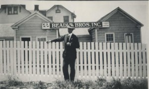
Green grass covered the hills and fields of potatoes surrounded the busy village. There were rumors that big landowner Loren Coburn was going to build a boom at the mouth of Pescadero Creek to catch the stray logs from the nearby redwood forests. You couldn’t live in Pescadero without hearing Coburn’s name. A man named Wilson rented 1600 acres from Loren. The 1700-acre Cloverdale Dairy, where 100 cows were milked for cheese and butter, was also rented from Coburn.

Up until this time few people had ever actually seen Loren Coburn.

—————-

*There were many other “wood” forests much closer than The Butano. I am referring to the forests just south of Half Moon Bay, where in the 1870s, sawmills had been set up. The fast-growing city of San Francisco also needed fresh produce from the Coastside, including the popular potato, a basic food.
Posted in Uncategorized | Comments Off on The Coburn Mystery: Chapter 37 (original ms.)

Coburn Mystery : Chapter 36 (original ms.)

(Photo: Charlie Lund at Pigeon Point)

By June Morrall

In th 1870s when Colonel S. Evans, author of “A La California” rode horseback into the remote village of Pescadero, he saw a village optimistic about the future.

Behind all that confidence was the lighthouse recently built at Pigeon Point by the U.S. government. The light had been illuminated for the first time on November 15, 1872.

That “slim finger” against the sky became a source of pride for the Pescaderans. Charles Swanton regularly escorted hotel guests on scenic tours into the lighthouse where Captain J.W. Patterson*, “an old salt,” was in charge.

A steam whistle had also been installed and during foggy weather the whistle sounded at intervals, with the blasts lasting four seconds.**

[Approximately $95,000 was appropriated for the Pigeon Point Lighthouse: $83,000 for the lighthouse and other buildings, $12,000 for the keeper’s residence.]

Soon a very small community surrounded the lighthouse: a store, school, post office***, and the blacksmith was building a new house. One of the Steeles was appointed postmaster.

Today it’s so serene at the lighthouse that it’s hard to imagine a bustling community there. But behind the lighthouse stood Pigeon Point Landing–a new wharf and chute, estimated to cost between $12 and $30,000. The men who financed the ambitious project rented the land from Loren Coburn. At the time Coburn was still residing with his family in San Francisco.

The investors modernized the previous primitive cable-rock arrangement, extending the wharf 100-feet into the ocean, dramatically improving the business of shipping. For the first time a vessel could land alongside the wharf, reducing loading time from four to six hours, instead of a couple of days. The “Arcata,” a three-masted schooner, one of the largest ships to stop there, once stayed for more than a week.

To further expedite the the shipping of local lumber and produce, the investors planned to build a “canal” and a six-mile long, three-foot gauge railroad track from Gazos Creek to Pigeon Point Landing. Those familiar with the old cable-rock arrangement, wondered why Loren Coburn hadn’t upgraded the wharf himself.

——–

*Captain J.W. Patterson was the commander of the shipwrecked “Shubrick.” He lived in a two-story white wood dwelling with a red roof. Capt. Patterson told visitors he came to the coast in 1823 aboard the “Mentor,” then sailed to Alaska where he traded furs with the Indians. In 1833 he sailed back to California. Sometime in the late 1870s Patterson was abruptly replaced by a new lighthouse keeper, Capt. Fairchild. “…it seems hard that a gray headed old man who has spent his life in going down in ships and is unprovided for should be removed from a small office to subserve no other ends than those of politics.” [no attribution.]

**In 1872 he Pigeon Point Lighthouse was officially inspected by the government “lampist,” Thomas Winship. There was also a steam fog whistle at Ano Nuevo Island, south of Pigeon Point. It sounded blasts of 15 secodns at intervals of 45-seconds. There was concern that the Ano Nuevo fog signal would be confused with the fog signal at Pigeon Point.

***Before the post office was built at Pigeon Point, folks who lived there rode horseback, six miles north to Pescadero to pick up the mail.

Posted in Uncategorized | Comments Off on Coburn Mystery : Chapter 36 (original ms.)

Eureka! at Nepune’s Vomitorium: John Vonderlin Finds More Yucky Golf Balls, Soggy Socks

John Vonderlin Finds The Usual Suspects at Neptune’s Vomitorium

Story & Photos by John Vonderlin

Email John ([email protected])

Hi June,

With Neptune’s Vomitorium becoming active once again, after a six month quiescence, I’ve been making twice weekly trips to Invisible Beach to gather its bounty.

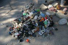
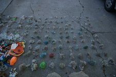
I was rewarded this past week, when, instead of continuing its decline in quantity and quality from its first appearance a few weeks ago, a Superwrack was coughed up. Included in the nearly hundred pounds of wet, stinky mass of marine debris I gathered were more then three hundred fishing line balls and a wide array of socks, tie wraps, goggles, golf balls, fishing gear and many more of the other “usual suspects.”

My previous record for collecting fishing line balls at one time was barely half that. Whether I can find the time to tie all of them, along with the several thousand others I’ve got stored, to the World’s Largest Fishing Line Ball, remains to be seen.

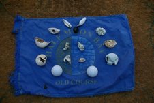
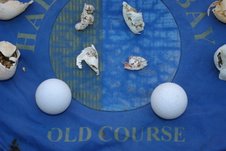
In a follow-up visit yesterday, I found what I call a “smoking gun,” or in this case a flapping flag. I’m referring to my golf ball remnant collection’s source. In my previous stories about Invisible Beach and its unnatural oddity, Neptune’s Vomitorium, I detailed my tracing the origin of the golf balls and remnants I was finding there, back to the Ritz Carlton, particularly the 18th hole of “The Old Course.” I think these pictures offer strong evidence that I was right.

The next time I’m up that way, I’ll drop in and find out where the flag was before it began “The Silent Procession from the Sunken Cathedral to Neptune’s Vomitorium.” Enjoy. John

Posted in Uncategorized | Comments Off on Eureka! at Nepune’s Vomitorium: John Vonderlin Finds More Yucky Golf Balls, Soggy Socks

Ocean Shore RR near Davenport

That’s what it says on the back side of this photo

Posted in Uncategorized | Comments Off on Ocean Shore RR near Davenport

What You Didn’t Know About The Ocean Shore RR & The Butano

Hello June.

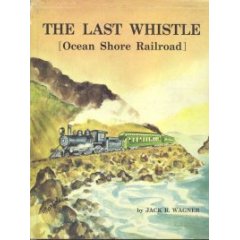
Some of your readers interested in the Ocean Shore R.R. may not know that efforts to resurrect it began almost as soon as it was abandoned. Jack Wagner’s THE LAST WHISTLE is the best reference.

I recall several San Francisco newspaper articles during the 1930s; and as a teenager I got up the nerve to go to the company’s office in downtown S.F. to inquire of its progress, and met the President, George Middleton. The office was shared with a mining company–either Alaska-Juneau Gold Mining or Bunker Hill. I can’t remember and don’t know of any relationship with the new OSRR. Mr. Middleton said the line would re-enter San Francisco by the old, seldom-used Southern Pacific’s Ocean View line. That track was now in the heavily built-up Mission District where people in homes could practically shake hands with the engine crew if a train ever went by. I remember being skeptical that the City would permit it.

Apropos of that time, I have a copy of the December, 1935, issue of “Railroad Stories” magazine and the article “The Ocean Shore Comes Back” by G. H. Kneiss, which told of the expected rebuilding mainly to exploit the timber resources of the Butano Forest

close to the original route, but never reached. There are a number of court cases involving the OSRR from that time on the Internet, mainly dealing with the railroad’s suits for incursions on its former right-of-way, some becoming precedents for other cases.

One of the more interesting is a 1941 appeal re an earlier decision about the injury from falling rocks in June, 1936, to a power shovel operator engaged by the railroad to clear the blocked north portal of the Pedro Point tunnel. A few months earlier the shovel had been “almost completely buried” by a slide at the south portal. I find it almost incredible how the shovel made it to the south portal. This was before Hwy. 1 had been re-routed closer to the coast, and so the shovel had to have taken the long route past Green Canyon and over Devil’s Slide on a roadbed neglected for over fifteen years. What problems the operator encountered can only be imagined. Mr. Wagner’s book chronicled how all these efforts came to naught.

Regards to John Vonderlin. Angelo

Posted in Angelo Misthos, Ocean Shore Railroad, The Butano, Uncategorized | Tagged , | Comments Off on What You Didn’t Know About The Ocean Shore RR & The Butano

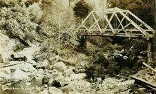
Is the Anderson Bridge Still Standing?

(Photo: Courtesy Tony Pera.)

I asked John Vonderlin: Is this a photo of Anderson Bridge? Is it still standing?

John said:
I believe the attached photos are of it. The photo you sent was of the bridge in its early years. I believe it was rebuilt in 1937 along with the other bridge slightly to the west. Then the railing was replaced a few years ago in a manner similar to its reconstructed style.

I believe it is the bridge right in front of the former “Flamingo House.” Unfortunately, I couldn’t find the Caltrans’s Bridge 40 designation on it. There was the plaque

from 1937 though. I’ll include articles about the Flamingo House, plastic flamingos, the bridge railing project and a few pictures. The pictures are of the plaque, the bridge, the former Flamingo House driveway, and the bridge from the creek. Enjoy. John

To read the article about the Flamingo House in Loma Mar, written by Joe Oesterie, click here

Posted in Uncategorized | Comments Off on Is the Anderson Bridge Still Standing?

South Coast Beaches: The Seven Sisters (cont’d) With “Wowie” Photos by John Vonderlin

The Seven Sisters (cont’d)
Story & Photos by John Vonderlin
Email John ([email protected])

Hi June,

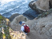
The next “Sister” to the south is the Acid Beach Arch. I’ve shared a few photos of this previously, both cliff-top and beach level shots, but here’s one of Larry Fitterer

who accompanied me down the cliff, standing inside it.

What amazed me most was, as Larry related in his email that you posted, was that his “ordinary” route down the cliff in the mid-90s, the northern route, included climbing down the cliff and across the top of the arch. Looking at this picture of the route along the descending ridge, that seems pretty crazy.

But if you go to the California Coastal Records Project (CCRP), and look at the 1972 picture, (#7219065) you can see a faint path to the head of the chute that people used to descend to reach the ridge above the arch. When Larry was climbing down in the 1990s, it must have been hairy, as the path was steeper and the arch’s roof narrower than in the 1970’s.

Today I’d rate it impossible or semi-suicidal.

If you’re braver, or crazier then me, start by examining picture #6419 (Acid Beach captioned) to get a good idea of what you’ll face. Then just be sure you straddle the knife-edge of the ridge as you descend and be prepared for a vertical jump down of more then twenty feet onto the roof of the arch. After you tightrope- walk across that, continue along the ridge on the other side of the arch and you should be able to find somewhere to safely slide down. Oh, and plan on climbing out a different route, as I wasn’t even able to climb the highly fractured rock up to the top of the arch from Acid Beach to get a “conquering” photo.

The southern route we used is much “safer.” It starts with a steep scree-littered chute at the southern curve of Acid Beach Cove. But the chute has several zigzags, allowing you to slow yourself down before you fly off the cliff, should you start sliding.

About one- third of the way down, the chute ends, and the crumbly cliff drops about ten feet down to a moderately steep scree slope that descends all the way to the rock shelf just above the ocean. By easing yourself on your butt a few feet down the ten- foot drop, then jumping to the south (left) where the scree slope is a few feet higher, it’s not too hard getting down safely.

As I mentioned previously, during my first climb back up, I loosened a lot of the crumbly hand and footholds, making climbing back up this way again very risky. Which is why you should bring a rope and attach it to the two poles someone drove into the rock at the bottom of the zigzag chute. Throw the rope over the cliff to the north, and you should be able to easily climb up and down a narrow trail that hugs the cliff. Unfortunately take this route, and just one mistake sends you hurtling all the way to the rocks 75- feet below on the beach; something you’ll be very aware of as you climb down.

Once you reach the scree slope, climb down it and walk along the spine of the promontory to its end.

An easy climb down gets you to a ledge from which you can access Acid Beach and the arch to the north if the tide is low.

Or you can head south to reach the small cove between Acid Beach and Warm Water Lagoon. To do the latter, you climb over the arch leading into the cove and follow a small ledge to its end.

Conveniently at the end, someone has recently tied a small ladder to a pipe where there had only previously been a rope. Undo that, lower it, climb down and you are in the coolest little cove I’ve ever seen.

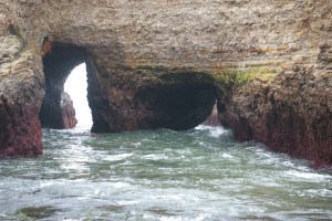
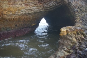
On the north side you’ll see a tunnel that forms the arch you just climbed over, and on the south side is the unique double Y-shaped Arch. There is also, or at least was, a small waterfall that pitter-patters down the sheer cliff to gently spatter on the wet sand exposed by the low tide. A very special place with a lot going on in the space of fifty feet. I hope you’ll enjoy it as much as I did. Much more to tell. Enjoy. John
.

Posted in Uncategorized | Comments Off on South Coast Beaches: The Seven Sisters (cont’d) With “Wowie” Photos by John Vonderlin

To The Friends of Orril Fluharty

Dear Friends of Orril Fluharty

Pescadero Community Church and the Family of Orril Fluharty invite you to join us in a Memorial Celebration of the life of Orril Fluharty,

2-July-1912 to 25-April-2008.

The Memorial Service will be held:

May 18, 2008 beginning at 11:00AM at

Pescadero Community Church

363 Stage Road

Pescadero, California 94060

650 879 0408

The Memorial Service will be held from 11AM to 12:15PM in the sanctuary.

Following the service there will be a break for the sharing of food followed by a time to celebrate Orril’s life in sharing, stories and music.

· Please feel free to forward this message to anyone wishing to receive it.

· Please respond with email addresses of others who would like to receive additional information as it becomes available or to be removed from the list

· Contributions of food, flowers, stories, poetry, music, art, assistance with logistics and other resources for the celebration are welcome

For inquiries please contact Rev. Detlef Matthies at [email protected] and I will forward your request.

In gratitude, celebrating the joy of Orril’s life and spirit

Detlef Matthies

Pastor

Pescadero Community Church, United Church of Christ

Posted in Uncategorized | Comments Off on To The Friends of Orril Fluharty

Orril Fluharty, RIP

Kerry Lobel wrote:
I just wanted to be sure that you had heard that news that Orril Fluhardy passed
away on Friday. thanks for all you do.

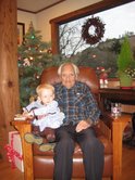
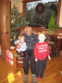
(Photos: Orril and Rowan Fluharty; Orril with great grandchildren; Orril, Rowan & Riley Fluharty. Courtesy Mike Fluharty)


—————
Flag at half-mast in Pescadero for Reverend Fluharty
(Thank you, John Vonderlin, for the image.)

Posted in Orril Fluharty | Tagged | Comments Off on Orril Fluharty, RIP

South Coast Beaches: The Seven Sisters

Story & Photos by John Vonderlin

email John ([email protected])

Hi June,

I like to make up names to designate various places and features I encounter in my explorations. Usually it’s a form of shorthand I can use when discussing matters with my traveling companions.

When running through various possibilities of places to visit during a given trip, “the beach just south of the cove we accessed from that parking spot across from the landslide near Pescadero Creek,” is way too cumbersome, especially if three or four similarly obscure, nameless locations are also considered as possibilities.

Usually I try to come up with a name that incorporates some salient feature of the destination, i.e. Abalone Cove, Eyeball Beach, Forbidden Zone or Neptune’s Vomitorium. Keeping this in mind, I’ve decided to call the Acid Beach area “The Seven Sisters,” because of its seven wonderful sea arches.

If you Wikipedia this name you’ll find it has a venerable and diverse tradition. There are “Seven Sisters” in everything from mythology, women’s colleges, mountain ranges, mainline Protestant sects, Baja California surf spots, oil companies, caves on Mars and many many more.

In this case I feel the “Seven Sisters” is a Freudianly appropriate designation for a collection of the seven best arches on the California coast. All within two hundred yards of each other, the arches define and highlight this amazing sheer-cliff-faced stretch of practically unknown and unvisited coast.

Several of them, the double arch of Warm Water Lagoon (WWL) and the two that form a Y-shaped double arch in the cove between Acid Beach and W.W.L., are unique as far as I know.

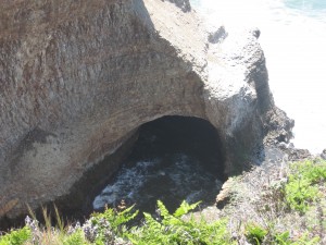
To fully appreciate this concentration of natural wonders, it’s best to see them up close. But, that’s not always possible, or safe. In a previous posting I shared a photo of the most northerly arch and described how you can reach it, by accessing it from Greyhound Beach, at extremely low tides, and climbing across an obstacle course of slimy rocks.

If the tide isn’t very low, or you don’t like long hikes, you can view it from the bluff top, just off Highway 1.

The promontory this photo was shot from is highly unusual itself. Screened completely from Highway 1 by pine trees, access to it is limited by bushes and a ridiculous growth of poison oak, but this has got to be the best coastal outlaw camping spot I’ve seen.

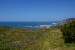
In fact, there were several sheltered “nests” under the sprawling pine trees, fifty yards from the highway that had been previously used. One even had seven five- gallon bottles of water stored there. Best of all, ocean-ward from the trees, the promontory turns into a kind of front lawn, a large flat area with grass and scattered flowers, instead of bushes. I can’t think why this is so, nor of any other spot on our coast quite like this. But, if I ever become homeless, you’ll know where to find me. This would be my waking view of Greyhound Rock with Ano Nuevo in the distance.

Enjoy. John

Posted in Acid Beach, Neptune's Vomitorium, The Seven Sisters, Warm Water Lagoon | Tagged , | Comments Off on South Coast Beaches: The Seven Sisters